
Prescribed Fire on the PSICC
An Overview
Prescribed fires, whether broadcast burning or pile burning, combined with mechanical and/or hand thinning treatments, are effective land management tools frequently used to reduce the accumulation of hazardous fuels, including old and dense vegetation.
In the ongoing effort to create and sustain resilient forests and grasslands, fire crews on the Pike-San Isabel National Forests & Cimarron and Comanche National Grasslands implement prescribed fire projects. Planned ignitions will begin when weather and fuel conditions become optimal for achieving management objectives while keeping smoke impacts to surrounding communities to a minimum. Weather and fuel conditions are closely monitored, and the prescribed burning program will continue as long as conditions remain favorable.
2025 Planned Prescribed Fire Projects
The Pike-San Isabel National Forests & Cimarron and Comanche National Grasslands regularly posts messages before, during and after prescribed fires. Follow us on Facebook @PSICCNF and X @PSICC_NF. Look for and use the specific hashtags for each burn.
Broadcast Prescribed Fire Projects
Pikes Peak Ranger District
| Project name | Size | Location | Status |
| Mothball Springs | 1,000 acres | 5 miles east of Woodland Park. (El Paso County) | Scheduled for Fall 2025. |
| Rainbow Gulch | 750 acres | Near Rampart Reservoir and Forest Service Road 300. (El Paso County) | 375 acres completed in Spring 2025. The remaining 375 acres are scheduled for Fall 2025. |
| Crystal Reservoir | 250 acres | Near Crystal Reservoir on Pikes Peak. (El Paso County) | Complete. |
South Park Ranger District
| Project name | Size | Location | Status |
| Road Gulch | 532 acres | Scheduled for Fall 2025 | |
| O'Brien 2 | 901 acres | Scheduled for Fall 2025 |
South Platte Ranger District
| Project name | Size | Location | Status |
| Green Mountain | 654 acres | Near Buffalo Creek Recreation Area and Forest Service Road 550. (Jefferson County) | Scheduled for Fall 2025. |
Leadville Ranger District
- None planned for 2025.
Salida Ranger District
- None planned for 2025.
San Carlos Ranger District
- None planned for 2025.
Cimarron National Grassland
- None planned for 2025
Comanche National Grassland
- None planned for 2025
Pile Burning
Pikes Peak Ranger District
- 673 acres of pile burning completed.
South Park Ranger District
- 945 acres of pile burning completed.
South Platte Ranger District
- 323 acres of pile burning completed
Leadville Ranger District
- None planned for 2025
Salida Ranger District
- 298 acres of pile burning completed
San Carlos Ranger District
- 69 acres of pile burning completed
Cimarron National Grassland
- None planned for 2025
Comanche National Grassland
- None planned for 2025
Mechanical Thinning Projects
Pikes Peak Ranger District
| Project name | Size | Location | Type | Status |
South Park Ranger District
| Project name | Size | Location | Type | Status |
South Platte Ranger District
| Project name | Size | Location | Type | Status |
Leadville Ranger District
| Project name | Size | Location | Type | Status |
Salida Ranger District
| Project name | Size | Location | Type | Status |
San Carlos Ranger District
| Project name | Size | Location | Type | Status |
Cimarron National Grassland
| Project name | Size | Location | Type | Status |
Comanche National Grassland
| Project name | Size | Location | Type | Status |
Monument Fire Center Prescribed Fire

Prescribed Fire Map
This map shows all the locations on the Pike-San Isabel National Forests & Cimarron and Comanche National Grasslands where both broadcast burns and pile burning may occur, including the current status of that particular project. It is a great resource for both forest neighbors and those visiting the Forest
Prescribed Fire Information
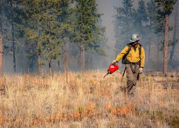
Fire Management Specialists may use prescribed fire to treat the land in much the same way a doctor prescribes medicine to treat a person. When a doctor prescribes medicine, it is under very specific conditions that the medicine is taken. When a prescribed burn is implemented, it is conducted under very specific parameters.
Public safety is always the first consideration for all fire management operations. Each prescribed burn has a detailed prescribed fire plan developed from the comprehensive planning efforts conducted long before the project activities are initiated. The burn plan provides guidelines for what objectives are desired, when and where to burn, under what conditions to burn, acceptable fire behavior, organization, contingency plans for fire control, smoke management and public concerns.
Also identified is the organization(s) that will be involved in the implementation of the burn and each person’s role on the burn. Daily weather conditions play a key role in whether a burn can be accomplished or not. This is why prescribed burns may be cancelled at the last minute and why predicting the exact day of a burn is difficult. Fire managers evaluate conditions and forecasted weather to make the best decision as to when to burn.
When the conditions are met, highly trained fire management personnel apply fire to the treatment areas, closely monitor the fire progress to ensure the fire stays exactly where it was intended and adjust ignition patterns as necessary to ensure the project objectives are met. Crews remain on site long after the flames subside to ensure containment lines are secure.
The primary objective when land managers conduct fuels reduction projects is to reduce the possibility of large wildfires, which can, among other things, generate dangerous amounts of smoke. The amount and duration of lingering smoke created from prescribed fires is minimal compared to the numerous dense smoke-filled days of this past summer due to the numerous large wildfires in the northwest.
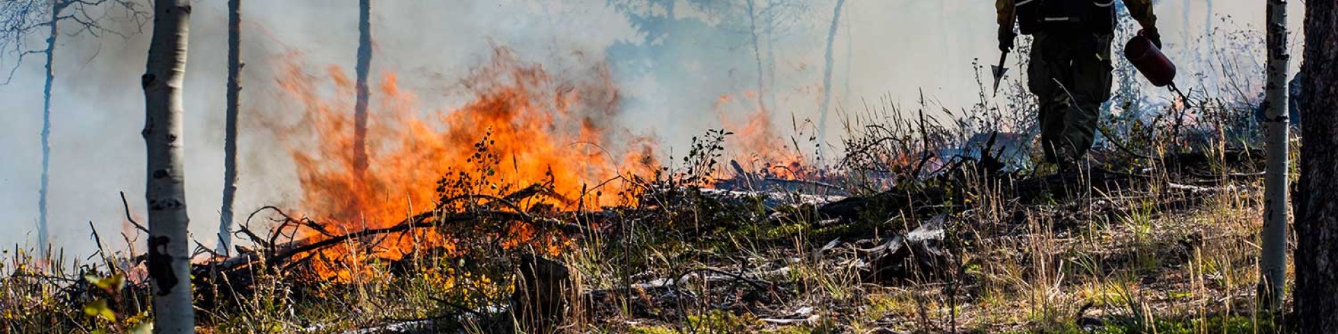
Fire managers on the PSICC use two prescribed fire techniques: broadcast burning and pile burning.
Broadcast burning: involves widespread application of fire to ground vegetation during a time when the vegetation is readily available to burn but not dry and volatile. Spring and fall are the most common times for this type of burning.
Pile burning: is the result of both hand and mechanical thinning operations. Crews cut small trees and limbs on live trees to reduce vegetation connecting surface fuels to trees. Crews stack piles of the debris in strategic locations where fire won’t ignite trees or other vegetation. Fire managers typically burn the piles when the area has adequate snow cover, which nearly eliminates the chance that ground fuels will ignite unexpectedly and makes the burn relatively easy to contain. Fall and winter are the most common times for this type of burning.
Piles are typically ignited mid to late morning. Hand piles burn actively for about an hour, which is when people will see the most smoke. Crews will push unburned materials into the pile to improve consumption, which will cause a short burst of higher activity and smoke. The piles then burn down over the next several hours. The majority of piles will be burned out by evening or overnight. Most people won't see much, if any, smoke after the first day.
Larger landing piles burn actively for several hours and take longer to burn out. Most smoke will be gone by evening, but piles may continue to smolder and may take a few days to be completely out. Crews patrol the piles daily.
Smoke from prescribed fires can often be seen for miles, but the amount and duration of lingering smoke created from small-scale prescribed fires is minimal compared to the numerous dense, dangerous smoke caused by massive wildfires throughout the west.
Smoke from all prescribed burns is closely monitored to ensure that the Colorado Air Pollution Control Division regulations and permit requirements are being met.
Prescribed fire smoke may affect your health. For more information, visit the Colorado Department of Physical Health and Environment.
After a burn, a visitor might see the area as simply black and barren. A closer look reveals the unburned bottoms of grass stems growing uninhibited by the dead grass layers that robbed the plants of water, nutrients and light.
In areas where there are trees, visitors should begin to see varied generations of tree populations that restart the natural progression of the ecosystem replacing old, diseased and dense vegetation.
Visitors who revisit the area can watch the landscape rebound from this natural change agent and witness the kind of event that shaped this land for thousands of years before humans intervened.
Other Fire and Mitigation Information
Fire in the wildlands is a natural process of the environment and has always played an integral role in the varied ecosystems on the Pike-San Isabel National Forests & Cimarron and Comanche National Grasslands (PSICC).
Many species of vegetation require occasional fires for health and sustainability. The vegetation and landscapes of Colorado are created primarily by fire and have adapted to fire. Fire is needed to maintain healthy forests, generate new forests and recycle nutrients in our dry climates.
The climatic pattern of spring drought followed by summer lightning storms has persisted for thousands of years in the southwest. Historically, frequent low- to moderate-intensity fires burned throughout the ponderosa pine forests of the Pike National Forest. Most of these fires were caused by lightning, extinguished themselves naturally and reduced the level of combustible forest fuels at regular intervals.
However, more effective suppression by humans over the past 100 years has altered the natural vegetation management tool and allowed fuel loads to build to levels that can now support large-scale high-severity fires. Other changes, such as climatic cycles, over this time have also increased the frequency and intensity of wildfires.
Meanwhile, population growth has increased the number of homes and communities that require protection. Greater demand for water has placed additional emphasis on protecting critical watersheds. Initial attack suppression is successful on about 98 percent of all fires on national forest lands. This is effective in the short term, but, in the long run, the inevitable consequence is higher-intensity fires that are harder (and sometimes impossible) to control and negative impacts to our communities and other values.
Proactive actions such as thinning and prescribed fire are needed across the landscape to reduce the hazard in the long run. Prescribed fire is a tool that can reduce risk to our values through reducing fuel loads as well as mimicking important natural processes such as recycling nutrients, improving vegetative diversity and wildlife habitat and regenerating grasses and shrubs.
Minimizing hazardous fuels, such as dead and down woody debris and brush, reduces fire intensity and the risk of high-severity wildland fires, which minimizes the risk to firefighter and public safety. Managing fuel loads also provides for the long-term sustainability of healthier ecosystems and the services they provide.
Kansas and Colorado grasslands developed with fire. Fire is an important part of maintaining healthy, diverse rangelands in Kansas and Colorado. Each spring, thousands of acres of grasslands are managed with prescribed fire.
Conduct your prescribed fires within safe conditions by checking the weather forecast and burning when the conditions are ideal.
At the conclusion of your burn, continue to monitor your burn area to make sure it hasn’t reignited. Smoldering debris can quickly become windblown embers that can spark a wildfire.
Communities are stronger when we work together. Gather your neighbors and community leadership to build your collective knowledge and take action to reduce wildfire risk and reduce the need for extensive firefighting actions to protect infrastructure, buildings, landscaping and the surrounding ecosystem during a wildfire.
Work with your community leaders to conduct a self-assessment of available resources, shared values at risk, community capacity to implement work plans and potential partnerships.
Because each community is unique, seek out guidance to create a Community Wildfire Protection Plan that considers the specific needs and goals of each community.