

Mobile GIS tool streamlines work for field-going technicians

ALASKA – It is a digital tool you see everywhere these days; a tablet or smaller wireless device that allows users to make use of pre-loaded applications to collect data for later use.
Waitresses take customers’ orders using them, allowing the cook back in the kitchen to start the meal preparation almost immediately. Healthcare workers add medical or dental information on their tablets to update a patients record. And now, Forest Service staff can paddle out in the vast Copper River delta to collect data on the Dusky Canada Geese’s conservation success rate and have key information compiled in ‘real-time’ for analysis back at the office.
This spring, the Tongass and Chugach’s Geographic Information System teams joined the regional office’s information management program and the agency’s Geospatial Technology and Applications Center to host a mobile GIS, in-person training for every Alaska region ranger district.
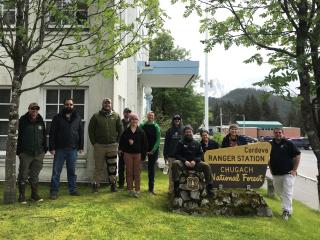
The most recent single-day training session was held in Cordova, Alaska. That’s where Monica Wey, a wildlife technician, and Madison Seigler, a forestry technician, along with a handful of other regional employees, learned all about to field data collection applications and device management.
“This was my first experience with GIS, and learning the mobile applications,” Wey offered. “I feel like I had an understanding of nothing and now I feel pretty proficient.”
Currently, Wey is a member of the Dusky Geese field crew. Their mission includes paddling out to nesting islands along the delta and working in small groups to collect data on tablets on the waterfowl’s reproduction success rate. They check nests for signs of eggshells or possible damage and record their findings on mobile applications that automatically synchronize to cloud-based services back at the office for later analysis.
“Learning these apps will directly impact the ability to do my job at dusky camp,” Wey added. “It gave me the training needed to be in the field.”
As a forestry technician Seigler, she took the training to improve her data collection skills for supporting habitat restoration for the marbled murrelet as part of an ongoing resource restoration project developed after the Exxon Valdez Spill over thirty years ago. The marbled murrelet is a shorebird found throughout Alaska and is a threatened species in other parts of the Pacific Northwest. The project’s goals include thinning timber stands to “try to keep up with how the forest should look like,” said Seigler.
“I wanted to refamiliarize myself with the mobile applications and implement these tools better on my own without relying on a supervisor or someone else,” said Seigler. “I can work more independently now.”
Those sentiments were echoed by fish biologist Eric Castro, who attended the training back in April at the Petersburg ranger district. Although Castro considers himself a more advanced user, he shared he did not want to miss the opportunity to gain experience directly from a GIS specialist.
“I feel somewhat of a responsibility to be able to try to help others within our unit, and maybe pick up some of the trainer’s skills,” Castro said. “That way, I'm able to learn the same information being taught by the specialist and function as an extension of the GIS program locally.”
Tongass GIS Program Manager Tom Huette largely organized the Tongass-based trainings. He traveled to Sitka, Thorne Bay and the Craig ranger districts to host the sessions and support device preparation for the field season. Chugach GIS Coordinator Caine Daugherty oversaw the training in all three of the Chugach’s districts.
Both Heutte and Daugherty collaborated with their teams and attendees to overcome challenges in skill level gaps and on-site network connectivity.
They hope to continue the trainings again in-person for the next field season. “Nothing beats meeting people in their workspace to support their field data collect goals,” said Heutte. “The most important thing actually wasn't my ability to teach them, but what I was learning about the data environment they're working in,” he concluded.
Daugherty agreed. “I think people just learn better when they have these face-to-face conversations, sit together, and have someone looking over their shoulder.” “It is just a better overall experience than trying to do this over Teams,” Daugherty said.