

Tree canopy assessments support flood response effort in Vermont
VERMONT — A slow-moving weather system in the Northeast in early July 2023 led to rainfall of 6-9 inches in just a few days across Vermont and caused catastrophic flooding in the state. As the rain was falling, and community leaders realized how severe the flooding might become, Jarlath O’Neil-Dunne received a phone call from an associate in Vermont State Government asking for help.
For the past 15 years O’Neil-Dunne has worked for the University of Vermont Spatial Analysis Laboratory and the USDA Forest Service Northern Research Station in a joint scientist position in a unique federal-academic partnership. O’Neil-Dunne began this shared position working with Research Forester Morgan Grove to develop processes and techniques to quantify urban tree canopy using satellite and remote sensing technology.
About 9 years ago, O’Neil-Dunne learned about a problem facing the small town of Plainfield, Vermont —the town had a creek running through, and with heavy rains, large amounts of woody debris washed down from its banks into the creek, flowing to the town’s bridge where it would pile up, damaging the bridge and causing local flooding. O’Neill-Dunne used technologies developed to monitor tree canopy assessments to begin an Unmanned Aircraft System program that used photography and modeling to help to locate and quantify the debris on the creek banks and provided analyses to aid the town in mitigating the hazard. His success with the Plainfield application led to a small amount of additional funding for the drone program from the Department of Transportation. As the drone program expanded and more applications were considered, more funding came in. The UAS program at the University of Vermont Spatial Information Lab has been supported and expanded into a robust drone program with funding from the US Department of Transportation, the Federal Aviation Administration, National Oceanic and Atmospheric Administration, and the US Center for Excellence in Research.
O’Neil-Dunne was attending a conference in San Diego when the heavy rains started. He received the urgent call for assistance from the State of Vermont. The UAS team at the Spatial Analysis Center stepped up to the challenge.
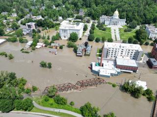
“It’s quite difficult to document the magnitude of the areas affected by peak flooding from the ground.” explains O’Neil-Dunne. “Imagery taken from the air, in this case from drones, can capture photos of the extent of damage more efficiently and effectively.”
The Spatial Analysis Lab’s UAS were able to apply techniques developed doing tree canopy assessments to inform local, state and federal leaders about the extent and severity of the floods. The lab’s drone data played a key role in FEMA’s damage assessment, which led to a Presidential major disaster declaration for the area. The declaration means that those most affected may be eligible for federal assistance to help them recover from the flooding.
“Our teams are flying every day there is not rain. I could not be more proud of them,” said O’Neil-Dunne. “This work demonstrates that research is more than just producing scientific publications. This research led to practical applications to support a community at a very difficult time.”
The Spatial Analysis Lab’s UAS team is continuing to support missions for Vermont, working with FEMA, the FAA, the Emergency Operations Center, NRCS, regional planning commissions and local government, as the state recovers from the catastrophic flooding.