

Researchers use machine learning to ID lost meadows
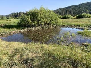
CALIFORNIA—Mountain meadows provide many benefits to forests, wildlife and people, but they can disappear over time due to climate change and human activity. USDA Forest Service scientists at the Pacific Southwest Research Station are using machine learning models to identify areas in California’s Sierra Nevada mountains where meadows once existed and can be restored to improve landscapes.
"Over time, a meadow and its many functions can be degraded and lost to the encroaching forest. Spaces that were once moist and open become filled with trees that can carry wildfire farther across the landscape," said Dr. Karen Pope, a Forest Service research ecologist. "Using machine learning and other tools, we now have a model that helps us see the potential for discovering lost meadows across larger landscapes. Once we know where they were, we can envision the possibility of restoring them."
Pope and fellow ecologist Adam Cummings used information about terrain and hydrology (water movement) characteristics in existing meadows to train machine learning models to predict where meadows may have been in the past. Across 60 Sierra Nevada watersheds they found the potential for almost three times the number of meadows that exist today. They also looked at places where restoring "lost meadows" could capture sediment from areas left bare from wildfires, and where restored meadows could support wildfire management.
"Meadows are like a hub in a wheel that connects habitat, water, climate, fire—all the things we care about in forest systems," said Cummings. Meadows “slow, spread and sink" the flow of water, so they support consistent stream flow in dry times and capture sediment, which improves the quality of water that goes to human communities.
Eric Nicita, a soil scientist for the Eldorado National Forest, said, “Meadows are usually small but have an outsized importance for watersheds. They are where water is stored, cooled and filtered. And when it comes to wildfire, meadows' wet conditions and lack of trees create natural breaks in vegetation that can interrupt the path of a burn.”

Pope and Cummings found several examples where existing meadows could be expanded or restored to better link and enlarge the network of wildfire containment features. They found that existing and lost meadows within the burn area of the 2020 Creek Fire could catch more sediment after fire and quadruple ground water storage if they were restored.
Once lost meadows are identified, restoring them is similar to thinking like a beaver.
“We can jump start natural recovery processes by strategically placing locally sourced wood, mud and brush dams in incised meadow streams to create speed bumps for water and sediment,” Pope explained.
Burned trees from wildfires can help form the non-permanent structures that help slow and spread the flow of stream water, which in turn helps sediment settle out and rebuild stream beds and soils. As the soil and water conditions are restored, the diversity of meadow organisms—including plants, fish, insects, amphibians and birds—return and thrive.
Land managers and stewards are now thinking about meadow restoration at a watershed scale, instead of on a meadow-by-meadow basis.
"It’s important to look at whole watersheds including uplands and waterways, doing comprehensive restoration at larger scales with more people involved," said Pope. "We can't do that without seeing the potential."