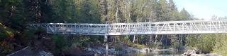
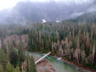
Repair of the Big Four Ice Caves Bridge has hikers back on solid footing to a popular destination in Washington’s North Cascades. After taking three years to secure funding, the Mt. Baker-Snoqualmie National Forest has bridged a 37-foot gap across the South Fork Stillaguamish River.
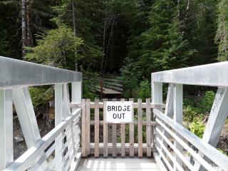
The Big Four Ice Caves Bridge had long been impacted by flooding and erosion along the riverbank, for well more than a decade. Safety issues required USDA Forest Service engineers to take precautions to prevent a bridge collapse. In 2006, the entire footbridge was removed. Re-installed in 2009, the aluminum bridge was eventually threatened by erosion again a decade later. In 2019, engineers removed part of the footbridge, making it unusable.
But now the bridge once again connects visitors to the other side, thanks to $241,000 of Great American Outdoors Act (GAOA) funding. With the bridge intact, recreationists can again access the iconic Ice Caves along the scenic Mountain Loop Highway.
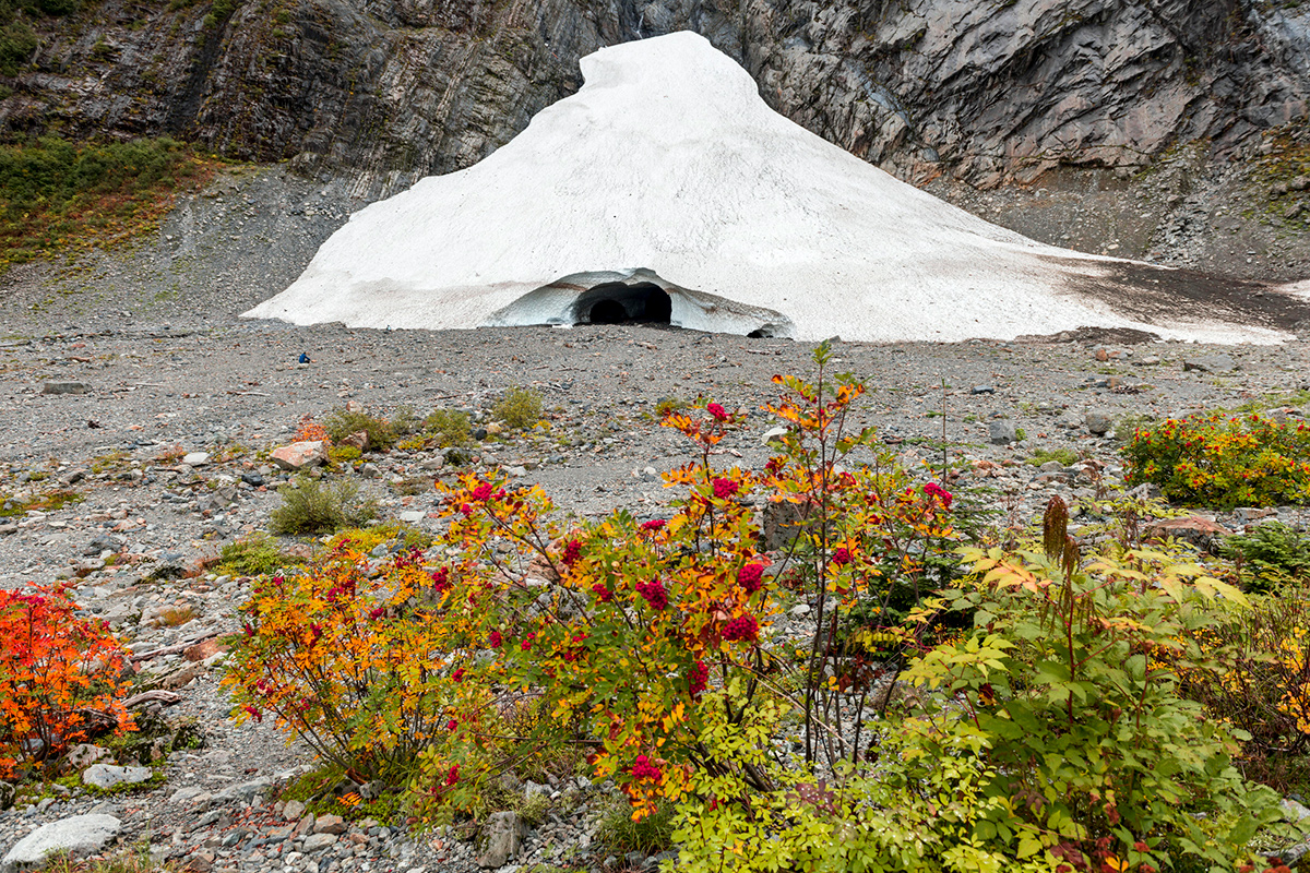
More than 60,000 people a year use the footbridge to access the 1.1-mile Ice Caves Trail. The destination is the blueish ice caves that form as avalanches scour down a chute along the 6,135-foot Big Four Mountain. These icy holes, referred to as caves, are exposed from July through October at the base of the snowfield. The caves seasonally increase or decrease in size, depending on the time of year. “In winter, the caves are re-built, and, in the summer, they are melting,” said Lucas Silvis, a Mt. Baker-Snoqualmie civil engineer.
During the October 2022 installation, engineers doubled the length of the replacement span from 37 feet to 74 feet, increasing the total bridge length to 261 feet to improve the structure’s integrity. “The bridge has been extended to reduce future risk of erosion,” Silvis said. “The longer bridge pushes back an additional 40 feet from the riverbank set in a more stable location.”
The importance of the bridge’s completion to the recreating public cannot be underestimated. The Big Four Ice Caves is a featured site on the scenic Mountain Loop Highway, highlighted by tourism entities like Seattle Northcountry.

Washington Trails Association, the largest hiking nonprofit in the state, applauds the completed trail access. “It’s great to have the Big Four Ice Caves Bridge re-installed because this is one of the most popular locations on the Mt. Baker-Snoqualmie and throughout Washington,” said Anna Roth, hiking content manager for Washington Trails Association, with its own WTA Big Four Ice Caves webpage.
The first step to ensuring a good hiking experience is to have adequate infrastructure to access trails. “It is important that trails have infrastructure like bridges so hikers can enjoy the outdoors safely,” Roth said. “Infrastructure is a basic aspect of meeting the needs of the public when they want to go explore their public lands.”
Since 2019, Mt. Baker-Snoqualmie sought to repair the bridge; however, funding was the major hurdle. “The biggest lag in time was to find the funding,” Silvis said. “If we had had money sooner, we could have done it sooner.”
GAOA answered the need. GAOA funds Forest Service outdoor recreation infrastructure by investing in deferred maintenance projects. GAOA has funded stalled road, bridge, and trail projects across the country. On the Mt. Baker-Snoqualmie, GAOA has provided more than $5 million for projects like this. “GAOA money has allowed us to get it done,” Silvis added.
Outdoor enthusiasts value the completion of deferred work on the ground, seeing how GAOA investments can open trails to thousands of hikers every year. “Hikers are part of the reason that the GAOA money was approved,” Roth said. “Washington Trails Association amplifies hiker voices by advocating for increased trail access. When hikers speak up about the importance of trails, it helps legislators understand how much we value access to the outdoors.”
Visit the Big Four Ice Caves
The Big Four Ice Caves Bridge is located 20 miles east of Granite Falls, Washington. Drive to the Ice Caves Trailhead off Mountain Loop Highway and Big Four Mountain. Hike the easy 1.1-mile portion of the Big Four Ice Caves Trail, also described by the Washington Trails Association.
Road Closure: The Mountain Loop Highway is open to Barlow Pass, with access to the Big Four / Ice Caves area. Travelers cannot drive the full 55-mile loop because the highway is partially closed due to winter damage.
Summer Cave Viewing: View the ice caves in early summer through fall. Openings are exposed typically from July through October.
Safety Alert: Always view ice caves from afar—from official viewing platforms. Do not approach or go inside ice caves. Hazards include avalanches, rockfalls, and icefalls. People have been injured or died in and around the caves.
Editor’s Note: The Legacy Restoration Fund, established by the 2020 Great American Outdoors Act, funds USDA Forest Service outdoor recreation infrastructure, by investing $766 million in approximately 1,000 deferred maintenance projects across 42 states and Puerto Rico. Explore the project dashboard.