
Official websites use .gov
A .gov
website belongs to an official government organization in the
United States.
Secure .gov websites use HTTPS
A lock
(
) or https:// means you've safely
connected to the .gov website. Share sensitive information only
on official, secure websites.


Motor Vehicle Use Maps
The motor vehicle use maps are legal documentation displaying the roads and trails that are open to public motor vehicle use. If a road or trail does not appear on the map it means that it is not open to public vehicular use.
MVUM maps are available one or more ways:
- Large downloadable and printable PDFs (see box below)
- Georeferenced PDFs through Avenza
- Printed maps at Forest Service offices
Download the Maps
There are four, large (44x34 inches) maps- one for each Ranger District.
- Blue Ridge District (2.6MB)
- Chattooga River District - (2.7MB)
- Conasauga District - (2.5MB)
- Oconee District - (1.7MB)
Also available is a booklet that formats this information into sections that will print on standard 8.5x11 inch paper for easy printing.
Download the booklet (5.4MB)
All of these files require Adobe Reader for viewing.
Map Number Locator
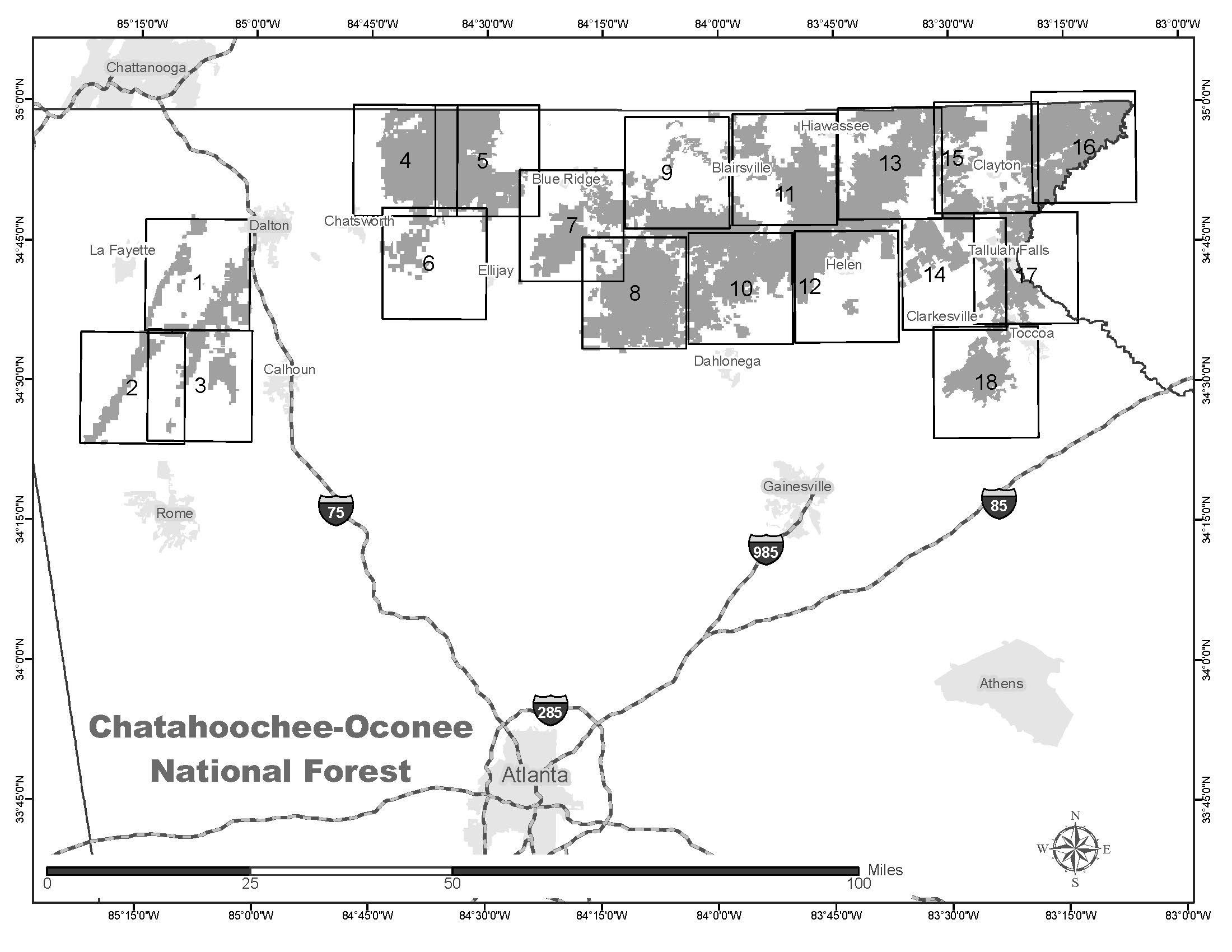
Chattahoochee National Forest
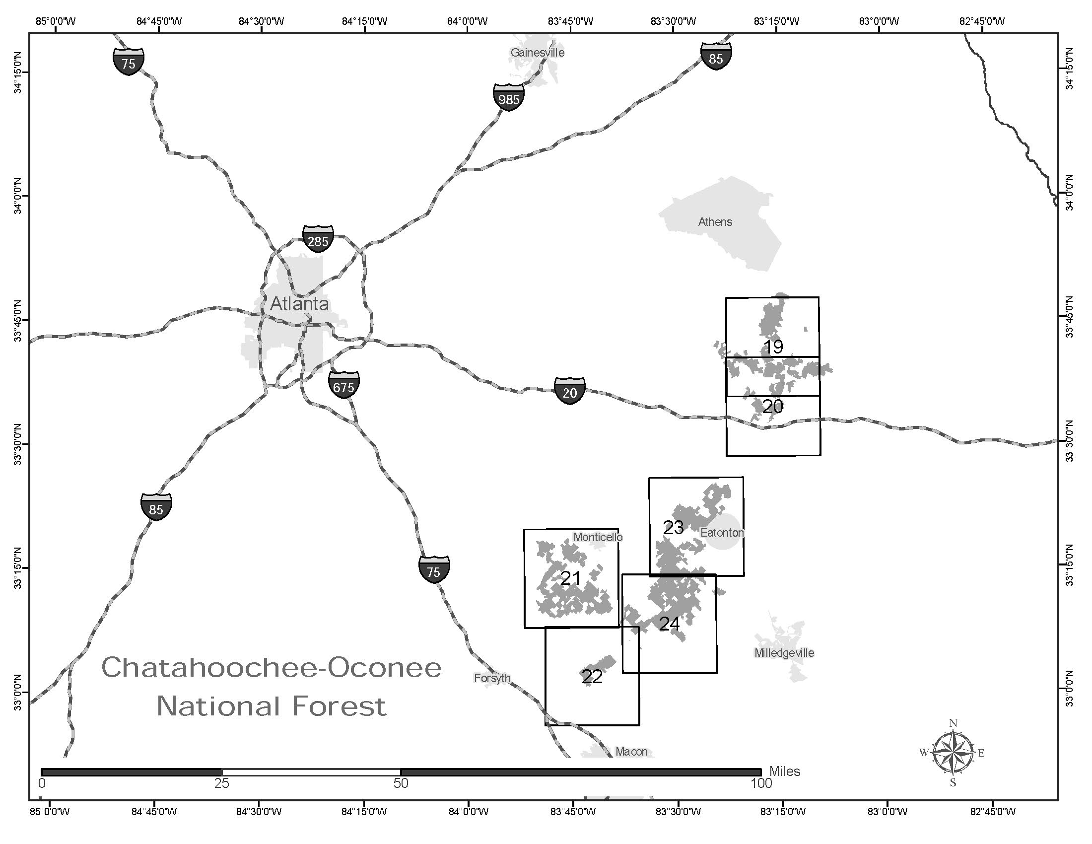
Oconee National Forest
Motor Vehicle Use Maps - Instructions and Disclaimers
TREAD LIGHTLY!
Travel & recreate with minimum impact.
Respect the environment and the rights of others.
Educate yourself plan and prepare before you go.
Allow for future use of the outdoors, by leaving it better than you found it.
Discover the rewards of responsible recreation.
For more information on Tread Lightly!, go to www.treadlightly.org or call 1-800-966-9900.
PURPOSE AND CONTENTS OF THIS MAP
This map shows the National Forest System roads, National Forest System trails, and the areas on National Forest System lands in the Chattahoochee-Oconee National Forest that are designated for motor vehicle use pursuant to 36 CFR 212.51. The map also contains a list of those designated roads, trails, and areas that enumerates the types of vehicles that are allowed on each route and in each area and any seasonal restrictions that apply on those routes and in those areas.
Designation of a road, trail, or area for motor vehicle use by a particular class of vehicle under 36 CFR 212.51 should not be interpreted as encouraging or inviting use, or to imply that the road, trail or area is passable, actively maintained, or safe for travel. Motor vehicle designations include parking along designated routes and at facilities associated with designated routes when it is safe to do so and when not causing damage to National Forest System resources.
Seasonal weather conditions and natural events may render designated routes and trails impassable for extended periods. Designated areas may contain dangerous or impassable terrain. Many designated roads and trails may be passable only by high-clearance vehicles or four-wheel drive vehicles. Maintenance of designated roads and trails will depend on available resources, and many may receive little maintenance.
This motor vehicle use map identifies those roads, trails, and areas designated for the motor vehicle use under 36 CFR 212.51 for the purpose of enforcing the prohibition at 36 CFR 261.13.
This is a limited purpose. The other public roads are shown for information and navigation purposes only and are not subject to designation under the Forest Service travel management regulation.
These designations apply only to National Forest System roads, National Forest System trails, and areas on National Forest System lands.
It is prohibited to possess or operate a motor vehicle on National Forest System lands on the Chattahoochee-Oconee National Forest other than in accordance with these designations (CFR 261.13)
Violations of 36 CFR 261.13 are subject to a fine of up to $5,000 or imprisonment for up to 6 months or both (U.S.C. 3571(e)).This prohibition applies regardless of the presence or absence of signs.
This map does not display non-motorized uses, over-snow uses, or other facilities and attractions on the Chattahoochee-Oconee National Forest. Obtain a forest visitor map for more complete information.
Designated roads, trails and areas may also be subject to temporary, emergency closures, and visitors must comply with signs notifying them of such restrictions. A national forest may issue an order to close a road, trail or area on a temporary basis to protect the life, health, or safety of forest visitors or the natural or cultural resources in these areas. Such a temporary and/or emergency closures are consistent with the Travel Management Rule (36 CFR 212.52(b); 36 CFR 261 subpart B).
The designation "road or trail open to all motor vehicles" does not supersede vehicle size or weight limits imposed through State traffic law.
OPERATOR RESPONSIBILITIES
Operating a motor vehicle on National Forest System roads, National Forest
System trails, and in areas on National Forest System lands carries a greater responsibility than operating that vehicle in a city or other developed setting. Not only must the motor vehicle operators know and follow all applicable traffic laws, but they need to show concern for the environment as well as other forest users.
The misuse of motor vehicles can lead to the temporary or permanent closure of any designated road, trail, or area. Operators of motor vehicles are subject to State traffic law, including State requirements for licensing, registration, and operation of the vehicle in question.
Motor vehicle use, especially off-highway vehicle use, involves inherent risks that may cause property damage, serious injury, and possibly death to participants.
Riders should drive cautiously and anticipate rough surfaces and features, such as snow, mud, vegetation, and water crossings common to remote driving conditions. Participants voluntarily assume full responsibility for these damages, risks, and dangers. Motor vehicle operators should take care at all times to protect themselves and those under their responsibility.
Much of the Chattahoochee-Oconee National Forest is remote, and medical assistance may not be readily available. Cellular telephones do not work in many areas of the Chattahoochee-Oconee National Forest. Operators should take adequate food, water, first aid supplies, and other equipment appropriate for the conditions and expected weather.
ALWAYS REMEMBER TO RESPECT PRIVATE LAND! PROTECT YOUR PRIVILEGE. STAY ON DESIGNATED ROADS AND TRAILS AND IN DESIGNATED AREAS.
Read and understand this map in its entirety. If you have questions, please contact the Chattahoochee-Oconee National Forest for clarification. Road, trail, and area users must comply with this map, as well as all Federal, State, and local laws and regulations. Forest roads are only open to registered vehicles and mopeds in accordance with state law (OCGA 40-2-20, OCGA40-2-8).
All other vehicles including “motorized carts”, “low speed vehicles”, and “all-terrain vehicles” are prohibited. (OCGA 40-1-1) Compliance with these rules is the responsibility of the user.
Official Motor Vehicle Use Maps determine if a road is open to public motorized vehicles. Contact our office for daily updates.
Please note roads may be closed at any time. Roads not on the map are not open to public vehicular use.
Please remember to practice TreadLightly! principles when traveling on public Forest Service roads.
Travel Responsibly
Respect the Rights of Others
Educate Yourself
Avoid Sensitive Areas
Do Your Part