
Official websites use .gov
A .gov
website belongs to an official government organization in the
United States.
Secure .gov websites use HTTPS
A lock
(
) or https:// means you've safely
connected to the .gov website. Share sensitive information only
on official, secure websites.


The Forest Service in Alaska
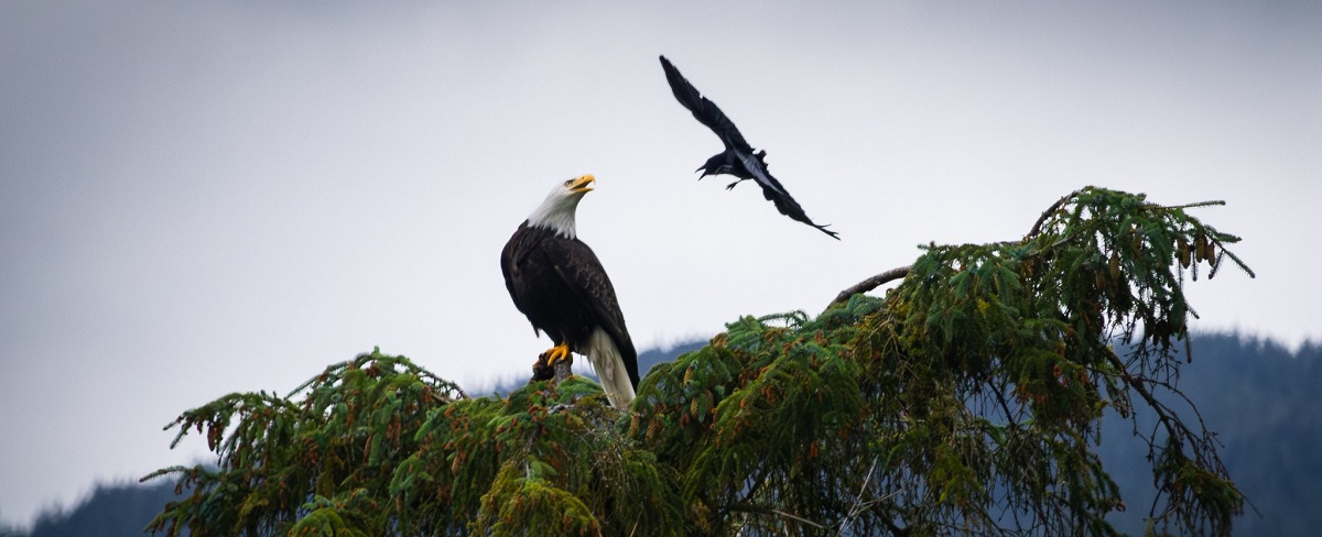
A bald eagle and crow in a territorial dispute. USDA Forest Service Photo by John Matuszewski.
The Alaska Region of the Forest Service encompasses two of the Nation’s largest national forests, the Chugach and Tongass, located in Southcentral and Southeast Alaska. From the Chugach National Forest and the famous Russian River of the Kenai Peninsula to the Tongass National Forest, which covers a large portion of Southeast Alaska, surrounding the famous Inside Passage, the Alaska Region offers amazing diversity and the most beautiful, famous, and stunning forests in the nation.
The Alaska Region is a land of extremes. In this land, massive Sitka spruce create cathedral-like forests. Frigid blue glaciers grind their way relentlessly through mountains. Humpback whales frolic in the waters encircling the forests. Brown bears wander the forest. The beauty and bounty of the national forests in Alaska draw attention from around the Nation and around the world.
The employees of the Alaska Region work with the public to manage nearly 22 million acres in Southcentral and Southeast Alaska. Vast watersheds filled with rivers, salmon streams, and glaciers are found here. Additionally, the State, Private, and Tribal Forestry staff reach across the boundaries of national forests to states, tribes, communities, and non-industrial private landowners. The Alaska Region of the Forest Service is a leader in protecting the land’s bounty while providing a place for people to work and play.
The Tongass National Forest stretches the 500-mile length of the Alaska Panhandle and encompasses more than 80 percent of the land. It’s home to the cities of Juneau, Sitka, Ketchikan, Petersburg, and more communities located in this vast temperate rainforest.
The Chugach National Forest makes a 210-mile arc around Prince William Sound. Alaska’s largest city, Anchorage, is an access point to the Chugach National Forest. The Chugach is home to Seward, Cordova, Valdez and more communities.
Local communities and tribes depend on national forest resources for daily living, including employment in the fishing and wood products industries, among others. Many residents make use of the fish, blueberries, deer, salmon, wood products, and other resources on the forests.
National and international visitors join local residents in exploring the rivers and trails that stretch from sea level to the alpine. Guided tours and cruises enable visitors to enjoy the wildlife and scenery, while independent travelers make their own opportunities for excellent fishing, kayaking, and camping experiences.
Alaska’s beauty and bounty, and the role of the Forest Service in managing the land, receive much national attention. Communities balance the use of and extraction of natural resources while conserving and protecting them.
How we are organized
- Regional Office, located in Juneau: Regional Forester and staff, program directors and regional specialists work out of the regional office.
- Forest Supervisor Offices, in Ketchikan and Anchorage: Forest Supervisor, program managers and shared specialists and services work out of forest supervisor’s offices.
- Ranger Districts: There are ranger district offices in Yakutat, Juneau, Hoonah, Sitka, Petersburg, Wrangell, Ketchikan, Craig, Thorne Bay, Girdwood, Cordova and Seward. Ranger Districts are individually managed portions of each forest with offices often in smaller communities. District Rangers and staff, field workers and summer employees typically work out of ranger districts.
- Admiralty Island National Monument: Similar to a Ranger District office, Admiralty has it's own headquarters located in Juneau.
View addresses and information for all of our offices.
Alaska contains 17 percent of all Forest Service lands and contains two of the largest national forests in the Nation. The Tongass National Forest stretches over the 500-mile-long Southeast Alaska Panhandle and covers over 80 percent of that land. The Chugach National Forest makes a 210-mile arc around Prince William Sound.
In all, we manage 21.9 million acres - but it doesn’t stop there… On the Chugach and Tongass National Forests are:
- Over 5.7 million acres of Wilderness
- 2.1 million acres of Wilderness Study Area
- 7.2 million acres of wetlands
- 57,000 miles of streams
- 12,600 miles are anadramous fish streams
- 400,000 acres of lakes
- Over 200 public recreation cabins & shelters
- Nearly 1,200 miles trails
- Over 3,500 miles of roads
- More than 1,500 special use permits
- Dozens of mines with operating plans
- Both established in 1907
Chugach National Forest Facts
- Headquarters (Supervisor's Office) in Anchorage
- 5.4 million acres
- Northernmost and westernmost U.S. national forest
- Approximately 210 miles east to west, 120 miles north to south
- Over 40 reservable cabins
- Approximately 500 miles of trail, about 200 miles are maintained trails
- Contains over 20 tidewater glaciers including the Columbia Glacier
- Only national forest with Dall sheep
- Home of the Begich, Boggs Visitor Center
- Contains the Copper River Delta - critical habitat for millions of birds annually
- Surrounds the world famous Prince William Sound
Tongass National Forest Facts
- Headquarters (Supervisor's Office) in Ketchikan
- Nearly 17 million acres
- Largest national forest in the United States
- Originally managed as 3 areas: Ketchikan, Stikine, and Chatham
- Stretches nearly 500 miles north to south
- Over 140 reservable cabins and shelters
- Over 450 miles of hiking trails
- Approximately 11,000 miles of saltwater shoreline
- More than 1000 islands
- Contains Prince of Wales Island, the 3rd largest island in the United States
- Contains two national monuments: Admiralty Island and Misty Fjords
- Over 5.7 million acres of designated Wilderness
Visit the Alaska Region Media Room