
Official websites use .gov
A .gov
website belongs to an official government organization in the
United States.
Secure .gov websites use HTTPS
A lock
(
) or https:// means you've safely
connected to the .gov website. Share sensitive information only
on official, secure websites.


Lookout Towers
 The State of Indiana first began to build lookout towers in 1930. At the time Indiana had only one fire tower. This tower was at Clark State Forest, which bore a sign proclaiming “Stay off. Unsafe to climb.”
One of the first challenges was determining where the high points were to build the towers. In the mid 1930’s, Indiana was one of few states that had not been completely mapped topographically. Without elevation maps, the job of locating towers on the most efficient high points was a hit or miss proposition. After 20 fire towers were erected, a complete visibility survey, with the use of special precision instruments, found that three towers had to be dismantled and moved, the remainder needed to be extended twenty feet in height, and eleven additional towers were needed.
By 1952 there were 33 towers in the state. Almost all were in the southern portion of the state. A map and listing of their location follows:
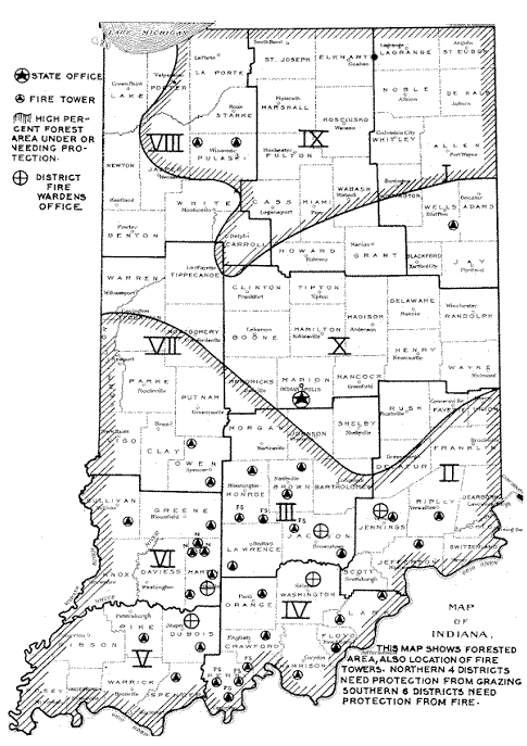
INDIANA DEPARTMENT OF NATURAL RESOURCES FIRE TOWERS
|
COUNTY |
NAME OF TOWER |
Location of Nearest Town Or State Property |
|---|---|---|
|
Brown |
Lilly Fire Tower |
Bear Wallow (near Nashville) |
|
Brown |
Weed Patch Tower * |
Lilly Dickey Woods |
|
Clark |
Henryville Tower * |
Clark State Forest (Coordinates: UTM - 16N, 603074, 4269100) |
|
Clark |
Borden Tower |
Borden, IN |
|
Crawford |
Taswell, IN (T2S, R1W, Sec 5) inc. latrine |
|
|
Dubois |
Ferdinand * |
Ferdinand State Forest (Coordinates: UTM - 16N, 519325, 4236342) |
|
Floyd |
Hickman Hill Tower |
Lanesville, IN |
|
Greene |
Cincinnati Tower * |
Cincinnati, IN |
|
Harrison |
Wyandotte Tower/Firetower 1942 * |
O'Bannon Woods (Coordinates: UTM- 16N, 564055, 4228254) |
|
Jackson |
Skyline Tower * |
Jackson State Forest (Coordinates: UTM- 16N, 583690, 4299847) |
|
Jefferson |
Five Points Tower |
Lancaster, IN |
|
Jennings |
Muscatatuck Tower |
(trying to determine location?) |
|
Lawrence |
Mitchell, IN |
|
|
Martin |
Lacy Tower |
Lacy, IN (near Shoals) |
|
Martin |
Willow Valley Tower * |
Martin State Forest (Coordinates: UTM - 16N, 523749, 4282891) |
|
Monroe |
Martinsville/Dickens area, Morgan Monroe State Forest (Coordinates: UTM - 16N, 549763, 4353470) |
|
| Monroe | Salt Creek | SE of Bloomington (T8N, R1E, Sec 8) |
|
Morgan |
Mason Ridge Tower |
Morgan-Monroe State Forest |
|
Morgan |
Wilbur Tower |
Martinsville, IN |
|
Orange |
Orange Fire Tower |
Paoli, IN |
| Orange | Paoli Tower | South of Paoli (T1N, R1E, Sec 29 NWSW) |
| Orange | Baker Tower | Southwest of French Lick (T1N, R2W, Sec 28), included a latrine. |
|
Owen |
McCormick Tower * |
McCormicks Creek State Park (Coordinates: UTM - 16N, 523344, 4348400) |
|
Owen |
Cataract Tower |
Cloverdale, IN |
| Perry | Bristow Tower | Bristow, IN (T4S, R3W, Sec 1) |
|
Pike |
Hartwell Tower * |
Pike State Forest (Coordinates: UTM - 16N, 486236, 4244631) |
|
Pulaski |
Jasper-Pulaski Tower | Jasper-Pulaski Game Reserve |
|
Pulaski |
Winamac Tower * |
Tippecanoe River State Park (Coordinates: UTM - 16N, 534222, 4551422) |
|
Ripley |
Versailles Tower |
Versailles, IN |
|
Spencer |
Lincoln City Tower * |
Lincoln State Park (Coordinates: UTM - 16N, 500875, 4216559) |
|
Sullivan |
Pleasantville Tower |
Greene-Sullivan State Forest |
|
Washington |
Salem Tower * |
Salem, IN |
|
Wells |
Ouabache Tower* |
Bluffton, IN (Coordinates: UTM - 16N, 659909, 4509717) |
* - Towers are still standing in 2003.
The U.S. Naval Ammunition Depot at Burns City in Martin County operated four towers during World War II.
- Fire Tower One - near the Bedford Gate is still standing and was used until the mid 1970s. Crane Structure 1853
- Fire Tower Two - ? The base now supports a water tower
- Fire Tower Three - Located on JT21, now has a repeater antenna on it. Crane Structure 44
- Fire Tower Four - ? This tower was torn down in January 2009.
U.S. FOREST SERVICE TOWERS
BROWNSTOWN DISTRICT
Monroe Co. - Hickory Ridge Tower * Plan approved 7/31/1937 to construct this 100 foot steel tower with a dwelling, garage, latrine and cistern.
Monroe Co. - Dutch Ridge Tower (T7N, R1E, Sec 27) said to have been a 80 foot tower. The footers are still visible.
Jackson Co. - Houston Tower (T7N, R3E, Sec 26 NWSW) said to have been a 100 foot tower. Had a latrine on site.
Lawrence Co. - Bryantsville Tower (T4N, R2W, Sec 36 NESE) said to have been a 100 foot tower with a latrine on site. This tower was likely the same as the Georgia Tower and may have been later leased to the State and manned by Indiana DNR staff.
Martin Co. Shoals Tower (T2N, R3W, Sec 7 NENE) Plan was approved 7/30/1937 to build this 100 foot steel tower. Included a dwelling, garage, latrine and a cistern.
LAFAYETTE DISTRICT (now Tell City)
Perry County -
- Marchand Tower planned approved 1/28/1938 to construct this 80 foot steel tower with a dwelling, garage, latrine, and cistern.
- Buzzard Roost Tower 100 foot tower with a latrine
- German Ridge Tower, 80 foot steel tower with picnic tables.
- West Fork Tower, plans approved 3/25/1938 to construct this 100 foot steel tower with a dwelling, garage, latrine and cistern.
Not all the fire towers were manned by men, at least two women are known to have served as regular lookouts in Indiana towers. In addition, during World War II, with so many men serving in the military, many women filled in as tower lookouts.
Clarisse Carroll, towerwoman for the Georgia Tower explained how her tower was constructed and what the lookout’s job was from 1950-1970:
“Fire towers were constructed of four angle iron bars, set in deep concrete about twenty feet apart, four square and ending a hundred feet in the air. There is a seven by seven foot cab constructed of a wooden floor, sheet metal and glass sides and a metal roof. One side of the floor is a door which the towerman lifts on his shoulders to enter and which he lets down on his back as he leaves. Inside the cab is a cabinet, directly in the center of the room on which rests an alidade, (an instrument consisting of a map mounted on a round rule marked off in degrees) used in mapping. The cabinet has a door and has room to store the psychrometer and weather book by which the towerman determines the fire danger.
The psychrometer, an instrument with a wet and dry bulb thermometer, is used for measuring the amount of moisture in the air. Three times a day, the towerman would leave the tower, go to the ground and twirl the psychrometer to pick up the air moisture and then mount the tower again and record the readings. One of the thermometers had a cloth fastened to the mercury end to catch the moisture in the air. It was necessary to go to the ground to take the weather reading as the air differs at a hundred feet high and fires start on the ground!
The furniture in the cab is one tall chair, a small electric space heater, kerosene heaters were used in the early days, a broom, a telephone which must be kept sitting on the floor so the wind wouldn’t knock it off and a C.B. radio sitting on a small iron box in which it can be locked up at night. C.B. radios were issued in 1951. Phones were party lines and when one number was called, all the phones on the line rang. Some people were habitual eavesdroppers, which could be an advantage. If someone called up and excitedly reported a fire, and the towerman wasn’t able to get the details, someone else listening on the line, surely heard.
Communication was important but early phone lines were strung haphazardly. So after a storm it was the towerman's responsibility to walk the telephone line, carrying an axe to clear limbs from the line or prop it up. He also cut away the briars or patched it up as needed. Clarisse said it was great relief when they got new telephone lines strung to the tower.
She further explains one gets into the cab by climbing sixteen steps to the first landing, turn right, fifteen steps to the next, turn right, twelve steps to the next and so on until one has climbed one hundred and twenty three steps. It was also necessary to carry a container of water, lunch and the weather equipment.
There was no housing at the base of the Georgia tower. Unlike the Forest Service, none of the Indiana State towermen were housed on the grounds. Bathroom facilities consisted of a two-seater under a tree. The grounds around the tower were about a quarter acre of grass which the towerman kept mowed and clean.
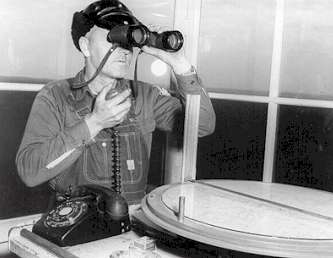 Unknown Indiana towerman with the tools of his trade in the cab of his firetower. The alidade, lower right, was a map with a siting mechanism which was used to determine the azmuth to a smoke. The fire’s location could be pinned down when triangulated with other towers.
Towermen often had to watch a smoke for 20 minutes or more to determine if the fire was someone burning off a garden and it would gradually subside, or if it were out of control and needed suppressing. Once he decided it was out of control and called a crew together, it often took 30-60 minutes before anyone arrived at the fire. This gave the fire a significant head start. Indiana foresters believed if a permit law was in effect, the towerman would know immediately which fires were managed and what to expect in watching their smoke columns. A law requiring anyone starting a fire to first acquire a permit went into effect on December 9, 1935.
Since eyesight was so critical for the job of towerman, an early fire manual declared “it is customary to require applicants for this work to demonstrate their seeing ability.” A vision test was devised by the State of Indiana. It was to be given between 9 am and 3 pm. The applicant was taken outdoors and was positioned several hundred feet from a black board. The board was changed so that it showed a white spot, 3/8 inch in diameter, at either end, or no spot. The applicant was required to recognize, at a minimum of 450 feet distance, which end of the board had the spot, or if no spot was shown. Exceptional applicants could make this distinction at over 550 feet.
Aerial Detection and the Demise of Towers
In the early years the lookout towers and planes worked cooperatively. The towerman would run up the American flag at their tower site to indicate they were on duty. At first, communication was only one way. If the planes needed to communicate with the towers they would fly over them and drop a note and the towerman would hurry down the tower to read the note and relay the message.
The Civil Air Patrol was used for several years, especially during the WWII era. Though planes could spot the fires, they had no communication with the ground so were required to drop written messages in order to convey fire locations. In areas where there were no towers located, the messages were usually dropped at police stations after the plane buzzed the offices to get attention.
Gradually, however, the use of planes for aerial detection was perfected. By 1972, the U.S. Forest Service provided aerial detection for most of the central part of the state during high fire danger.
By the turn of the century however, air patrols were again less common, and in the 21st century fires are generally detected and reported by area residents.