
Official websites use .gov
A .gov
website belongs to an official government organization in the
United States.
Secure .gov websites use HTTPS
A lock
(
) or https:// means you've safely
connected to the .gov website. Share sensitive information only
on official, secure websites.


Tinder Fire
Tinder Fire Basics
Started: Friday, April 27, 2018
Location: East Clear Creek, 1.5 miles east of C.C. Cragin Reservoir
Cause: Illegal campfire
Size: 16,309 acres
Personnel: At the peak, 695 personnel, 15 crews, 7 helicopters, 46 engines, 7 dozers, 16 water tenders.
100% Contained: May 24, 2018

View more photos on Flickr.
On the heels of a dry winter, the 2018 fire season arrived early for northern Arizona. The previous winter had seen approximately one third the normal precipitation levels in the Mogollon Rim area. April was particularly dry and windy, with unseasonably warm daytime temperatures. Four Red Flag Warnings had been issued by the National Weather Service for the area since April 1. Daytime highs were often five to ten degrees above normal. The area where the Tinder Fire started had seen 25% of normal precipitation for the month. Stage I fire restrictions had been implemented April 23 in response to the dangerously dry conditions, strong winds, and forecast warm weather. In the days leading up to the Tinder Fire, temperatures were 10 to 15 degrees above normal.

Panoramic view of the Tinder Fire from Moqui Lookout, April 30, 2018 (USFS/Brady Smith)
[454 kb JPG 2048x914]
The Tinder Fire was spotted at 11:43 a.m. on Friday, April 27, 2018, burning approximately 1.5 miles east of C.C. Cragin Reservoir (aka Blue Ridge Reservoir) on the Mogollon Rim Ranger District. The wildfire was human-caused, sparked by an illegal abandoned campfire during fire restrictions. The wildfire was burning in an area of standing pine and mixed conifer forest going into the bottom of East Clear Creek. Due to the complexity of the fire, challenging terrain, risks to nearby residential communities, severely dry conditions, windy weather, and other factors, a Type I Incident Management Team (IMT) was called in. On April 28, the Type I Southwest Area IMT arrived and took command of operations.
Red Flag Warning, Wind-driven Wildfire Growth, and Evacuations
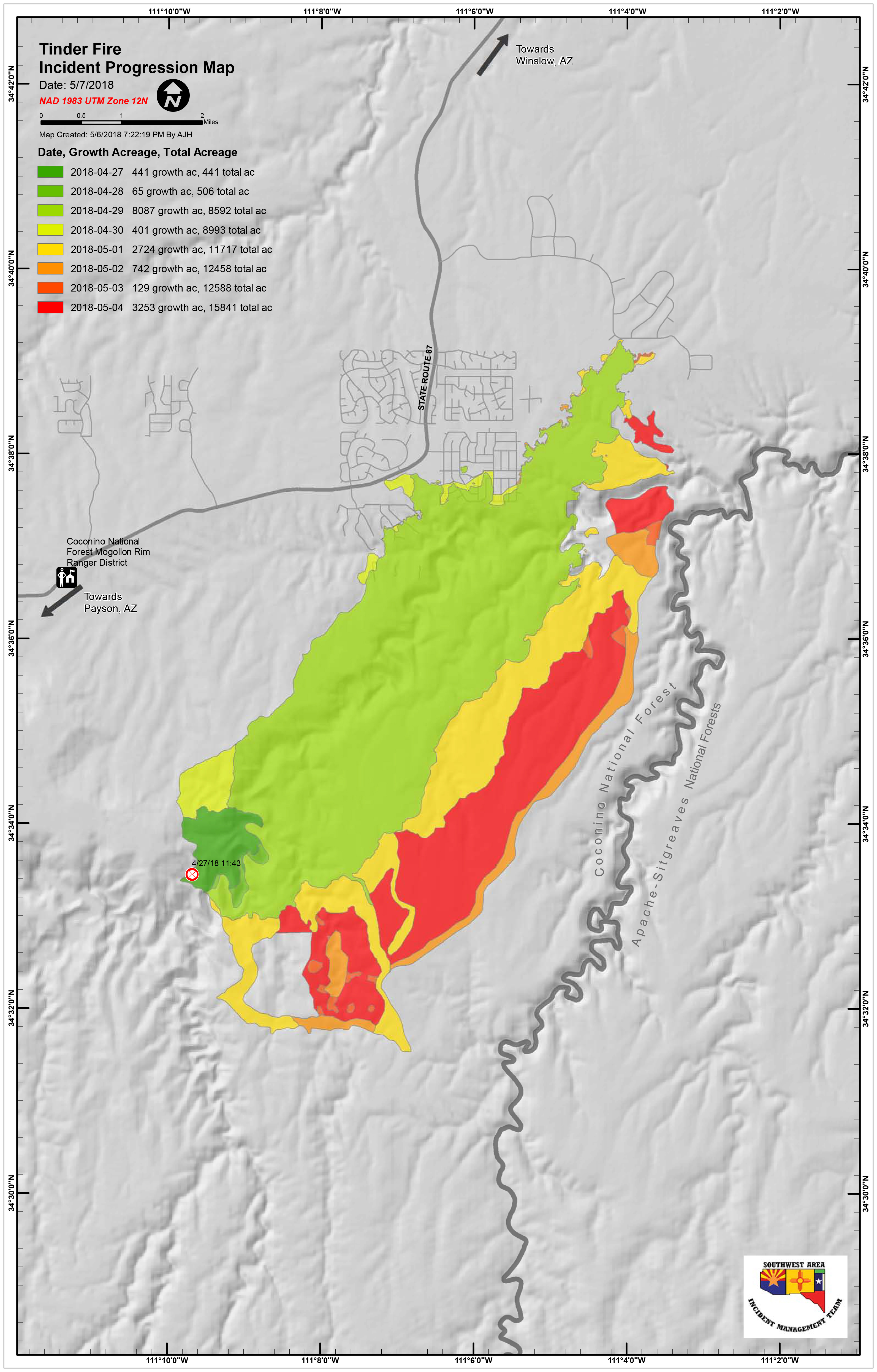
Tinder Fire Progression Map
[4.2 MB, JPG 3185x4984]
High winds were forecast for Sunday, April 29, and a Red Flag Warning was issued by the National Weather Service. Overnight, the wildfire had spotted across to the east side of the East Clear Creek drainage, and Hotshot crews were sent to secure the three growing fires that had been established.
By 10:00 am, winds were gusting around 40 miles per hour, and the Coconino County Sheriff's Office started ordering evacuations of the southernmost subdivisions in the path of the wildfire. The southwest wind was aligned with East Clear Creek drainage, pushing the fire quickly up the canyon. By 1:30 p.m., all the Blue Ridge area subdivisions were under evacuation orders. The Coconino National Forest issued a Forest Order closing the area around the wildfire, Arizona Department of Transportation (ADOT) closed State Route 87 to the north, and the Federal Aviation Administration (FAA) implemented a Temporary Flight Restriction (TFR) over the area. The wildfire grew rapidly from around 500 acres in the morning to approximately 8,000 acres by the end of the day. High winds grounded air tankers until early evening, and drove the fire into four communities. In the end, 33 primary residences were lost, as well as 54 outbuildings and other minor structures in the Blue Ridge communities south and east of State Route 87.
Drone Intrusion
Air operations were shut down for 15 minutes the morning of April 29 due to an illegal incursion of an Unmanned Aircraft System (UAS), commonly called a "drone," at the northern end of the wildfire around 10:15 a.m. The FAA had implemented a TFR restricting all air travel, including UAS, in the airspace above and around the wildfire. TFRs over wildfires protect emergency crews and aircraft actively engaged in fire suppression efforts. Air operations are required to shut down when any unauthorized incursion occurs, grounding firefighting aircraft. Delays due to incursions by UAS and other aircraft can lead to loss of property and lives. Luckily, there were no serious impacts from this incursion, but precious time was lost on what would become the worst day of this wildfire.
Wildfires and drones don't mix [FAA]. Flying a drone over a wildfire without authorization, regardless of whether or not the FAA has issued a TFR, is illegal. Violations may result in serious civil and criminal penalties, including hefty fines and jail time. Learn more about Drones and Wildfire from the National Interagency Fire Center (NIFC). Visit the FAA's Know Before You Fly to learn more about the requirements and laws governing UAS flights.
Securing Property and Returning Residents to Communities
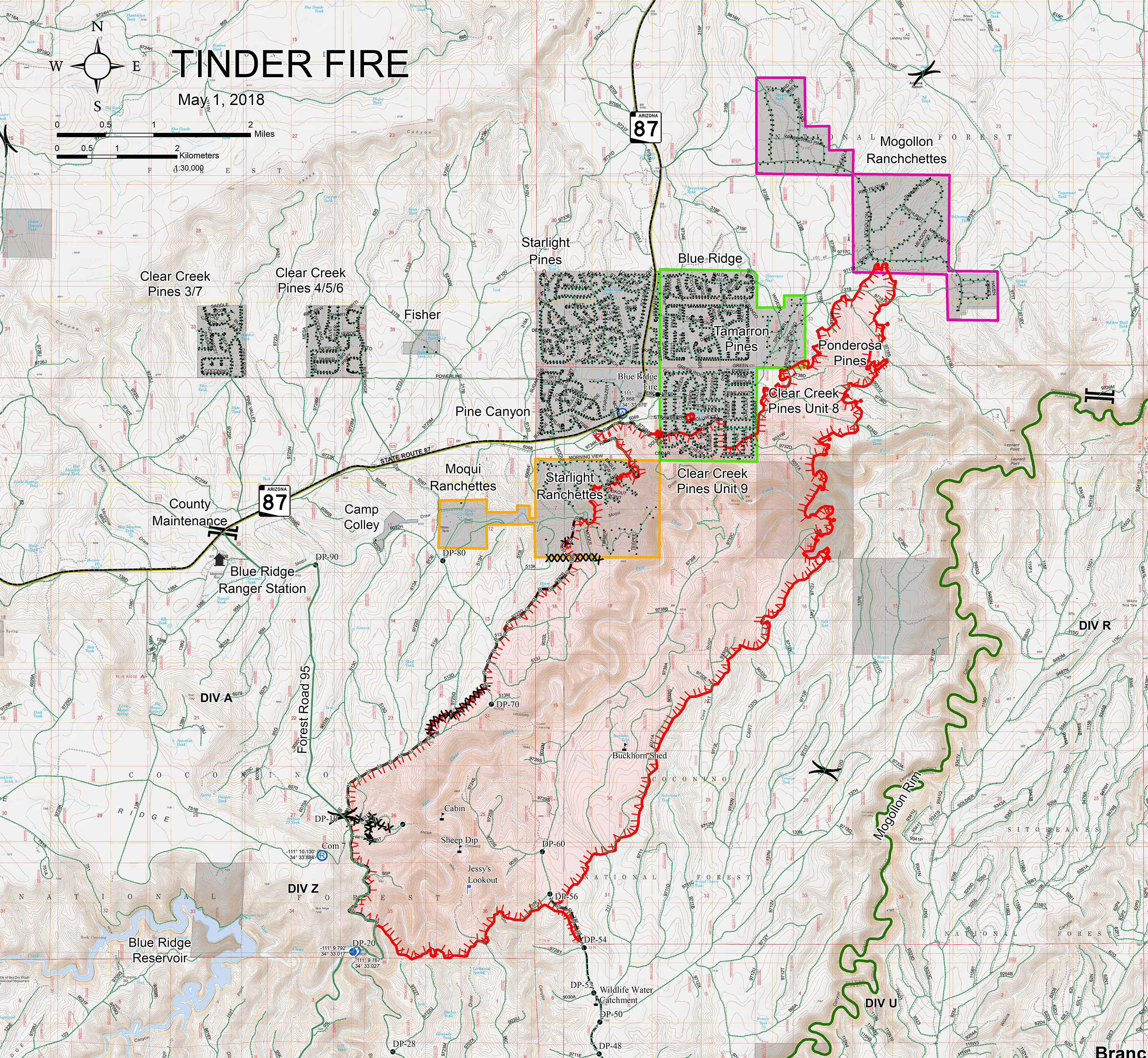
Tinder Fire Cover Map
May 7, 2018
[8.1 MB, JPG 2765x2550]
Over the following days, crews continued to work to suppress and contain the wildfire, and patrol and protect communities and structures. In communities directly impacted by the wildfire, crews sought out and extinguished remaining hot spots, mopped up the perimeter, and repaired damage caused by suppression activities. Arizona Power Service (APS) worked to replace damaged poles and restore compromised power lines so power could be restored. Five utility contractors tested propane systems and replaced damaged propane tanks. Once the communities were deemed safe, the Coconino County Sheriff's Office lifted the evacuation order, allowing residents to return to their properties Friday, May 4.
Winding Down in Windy Weather
The first few days of May brought increased humidity and precipitation. Snow and rain on May 2 helped limit fire activity. Crews quickly made progress towards containment on the wildfire, which had grown to over 12,000 acres. As warmer, drier weather moved in, fire personnel continued working to fully suppress the wildfire where they could do so safely and effectively. Crews performed burn-out operations, repaired damage caused by suppression efforts, mopped up, improved firelines, and patrolled the area. The Type I Southwest Area IMT transferred control of operations to a Coconino National Forest Type III team on May 7. By this time, the wildfire had grown to 16,309 acres and was 79% contained.
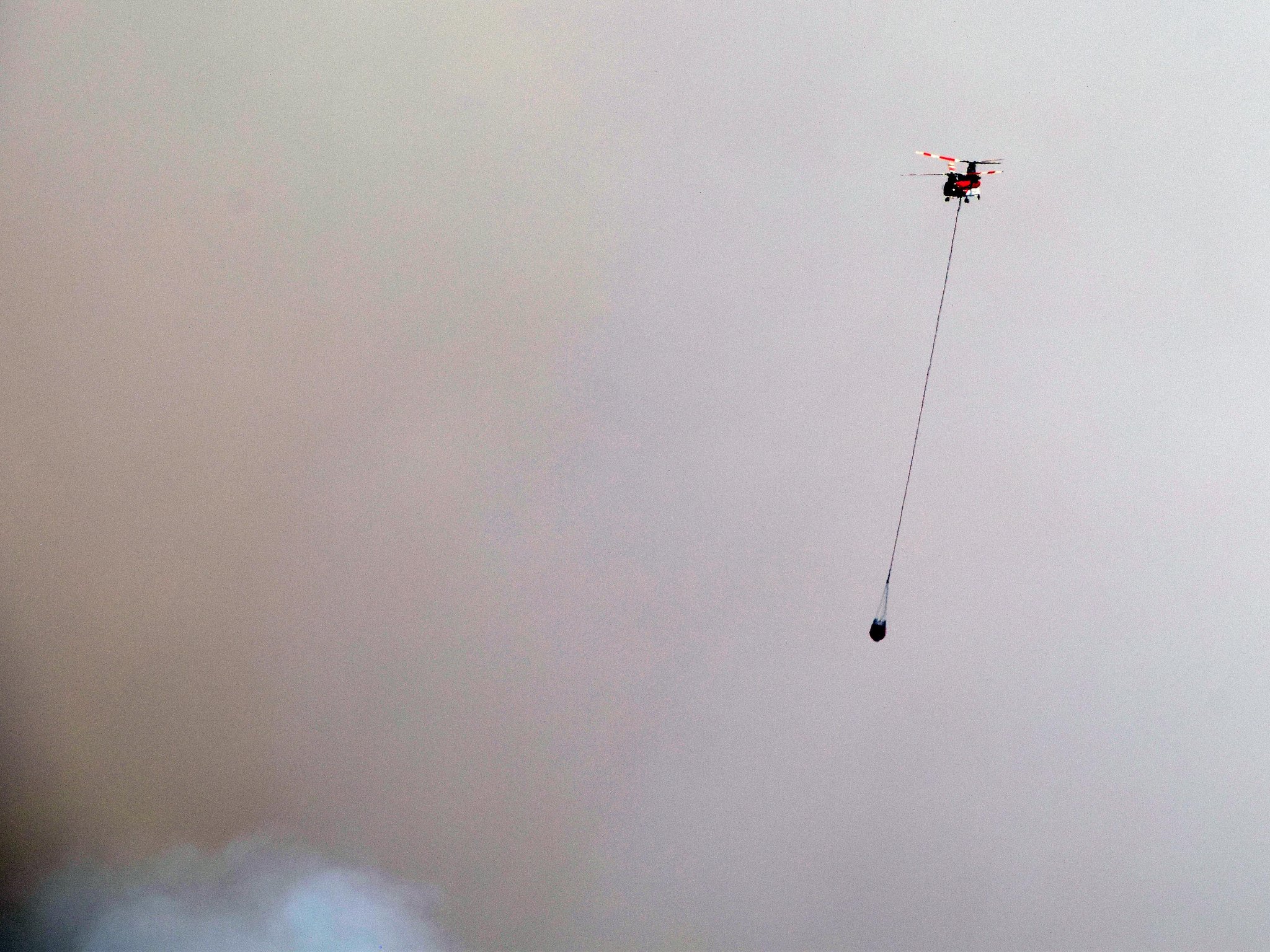
Helicopter performing bucket operations on the Tinder Fire. View from Moqui Lookout, April 30, 2018 (USFS/Brady Smith)
In expectation of windy conditions, Coconino National Forest and Arizona State Forestry crews worked to secure the northwest section of the wildfire May 9. The steep and rocky terrain of East Clear Creek canyon makes ground suppression efforts hazardous. Three helicopters with buckets were deployed to douse the area with water pulled from C.C. Cragin Reservoir. In advance of the strong and gusty winds forecast for the next two days, ground crews were staged to suppress portions of the wildfire trying to leave protection lines. The air and ground efforts were successful, resulting in no additional growth of the wildfire. Operations were stepped down to a Type IV crew on May 12.
Visit Tinder Fire on InciWeb to view maps, news releases, and other information.
Hazards and Temporary Area Closure
The temporary closure of the area around the Tinder Fire remains in effect until the end of the 2018 monsoon season, potentially later if conditions dictate. Flash flooding, falling trees and limbs, flowing debris, and rolling rocks create a high risk to human life and safety in the burn area. This is particularly true of East Clear Creek, a major drainage collecting runoff from the burn area. Flash floods and flowing debris along East Clear Creek and other canyons and drainages in the area are expected during heavy monsoon rains. The terrain in the area rises as it approaches the Mogollon Rim to the south. Due to this fact, water flows north, away from the Mogollon Rim.
The closure area encompasses all of East Clear Creek and surrounding area from the junction of Forest Roads 95 and 96 northeast to where the creek crosses the forest boundary, including Kinder Crossing, Horse Crossing, and Mack's Crossing trails. See the Tinder Fire Area Closure Forest Order [PDF] for full details.
Back to Fire Danger & Management
