
Official websites use .gov
A .gov
website belongs to an official government organization in the
United States.
Secure .gov websites use HTTPS
A lock
(
) or https:// means you've safely
connected to the .gov website. Share sensitive information only
on official, secure websites.


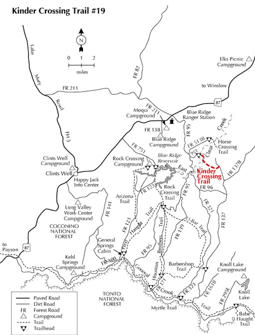
Kinder Crossing Trail No. 19
This trail offers a picturesque access to East Clear Creek, crossing the creek near a moderately deep section. There are excellent opportunities for fishing and sightseeing. Expect the trail to be steep and rocky in places. Some hikers limit their trek to the three-quarter mile hike to the creek. Others, however, venture across the creek for the additional three-quarter mile section. No cairns or blazes mark the extended trail which heads downstream then turns east up ridge and connects with FR 137.
Motorized vehicles are not allowed on this trail. FR 95T is usually closed each winter during heavy snow season.
Hover mouse cursor over photo to display slideshow controls.

At a Glance
| Usage: | Medium |
|---|---|
| Closest Towns: | Happy Jack, AZ |
| Operated By: | Mogollon Rim District - 928-477-2255 |
General Information
General Notes:Rating: Moderate
Elevations: Beginning: 6977, Ending: 7000. High/Low Points: 7000/6500 feet.
Notes:
- High clearance vehicles are strongly recommended due to rutted and rocky condition of FR 95T.
- Road can be very slick when wet and closed to vehicles in winter.
Directions:
Location: Southeast of Flagstaff
GPS (Map): 34°34'12.0"N 111°08'56.8"W
Access: From Clints Well go north on Highway 87 approximately 10 miles, milepost 300, just beyond the Mogollon Rim Ranger District. Turn right (south) on FR 95. Drive about 4.5 miles to FR 95T and turn left (east). Go 0.6 miles to the trail sign at fork in the road. The actual trailhead is 0.1 mile to the right.
Click on map thumbnail for larger view.
Activities
Day Hiking

Related Information
Location

