| FEIS Home Page |
The approximately 28,500-acre FBWMA is managed by the Maryland Department of Natural Resources and consists of wind-driven tidal marshes. The FBWMA receives about 43.7 inches of average annual rainfall and sits at or near sea level.
Study areas 1, 4, 5, and 6 are predominantly salt marsh habitats (higher salinities), and areas 2 and 3 are brackish marsh habitats (lower salinities). Lightning fires occur in both the BNWR and FBWMA from June through October [1].
PREFIRE PLANT COMMUNITY:Plant communities in the 6 study areas are dominated by saltgrass (Distichlis spicata), black rush (Juncus roemerianus), Olney threesquare (Scirpus americanus), smooth cordgrass (Spartina alterniflora), and saltmeadow cordgrass (S. patens). Olney threesquare and smooth cordgrass dominate study areas 2 and 3, and study areas 5 and 6 are dominated by saltgrass and saltmeadow cordgrass. Saltgrass, Olney threesquare, smooth cordgrass, and saltmeadow cordgrass were present on all 6 study sites. Black rush was only found in study areas 1 and 4 in considerable numbers, was rare in areas 5 and 6, and not present in areas 2 and 3.
These plant communities regularly experienced fire prior to the study. Prescribed burning in both areas was conducted on 1, 2, and 3 year rotations in the past.
PLANT PHENOLOGYThe fire dates for annual and 3 year burns in study areas 1 through 6 are presented in the table below. No annual burn observations were made in study area 3 for 1999. An arson fire occurred in study area 4 on 2 February 2002, so no observations were made in the area for annual burn in 2002. All fires in the study were of low severity.*
| Study area | Annual burns | 3-year burn |
| 1 | Winter: 21 February 1999 | Winter: 23 January 2001 |
| 29 February 2000 | ||
| 23 January 2001 | ||
| Spring: 25 March 2002 | ||
| 2 | Winter: 30 January 1999 | Winter: 3 February 2001 |
| 15 February 2000 | ||
| 3 February 2001 | ||
| 15 March 2002 | ||
| 3 | Winter: 15 February 2000 | Winter: 18 February 2001 |
| 18 February 2001 | ||
| 21 February 2002 | ||
| 4 | Winter: 28 January 1999 17 February 2000 11 February 2001 |
Winter: 11 February 2001 |
| 5 | Winter: 29 January 1999 | Winter: 28 January 2001 |
| 17 February 2000 | ||
| 28 January 2001 | ||
| 8 February 2002 | ||
| 6 | Winter: 29 January 1999 | Winter: 3 March 2001 |
| 17 February 2000 | ||
| 3 March 2001 | ||
| 5 February 2002 |
In September 1998 a study was initiated to assess the affects of annual and 3-year fire rotations on marsh plants at BNWR and FBWMA. Seven months prior to the initiation of the study all sites (annual, 3-year, and control sites) were burned under prescription. These fires were not described in the study. Control 1 had been under a 10-year burn rotation, and control 2 had been a nonburn or fire exclusion area. From 1999 to 2002 annual burns were conducted in study areas 1 through 6, except for in area 3 in 1999 and area 4 in 2002. For prescribed burns a head fire was used. The fires primarily took place in late winter when temperatures were cold to cool. In general, the fires took place from late morning to early afternoon. Flame heights ranged from 6 to 15 feet. The rate of fire spread was highly variable. The table below describes the ranges of air temperature, relative humidity, wind speed, and rate of spread for the 4 annual burns in the 6 study areas:
| Study area | Temperature (°F) | Humidity (%) | Wind speed (mph) | Rate of spread (ft/hr) |
| 1 | 37-60 | 37-67 | 3-10 | 105.6-16,374.6 |
| 2 | 37-72 | 37-84 | 2-17 | 250.8-44,998.8 |
| 3 | 34-69 | 47-62 | 4-10 | 1,867.8-9,715.2 |
| 4 | 35-65 | 50-66 | 0-10 | 1,452.0-13,860.0 |
| 5 | 42-52 | 31-49 | 4-15 | 6553.8-15,655.2 |
| 6 | 35-56 | 31-55 | 0-15 | 1,980.0-7,629.6 |
The prescribed fires in the 3-year fire rotation study areas were conducted in the winter of 2001 when temperatures were cool, humidity was moderate to high, and wind speeds were low. The table below describes the air temperatures, relative humidities, wind speeds, and rates-of-spread for the 3-year burn in 2001 in the 6 study areas.
| Study area | Temperature (°F) | Humidity (%) | Wind speed (mph) | Rate of spread (ft/hr) |
| 1 | 39 | 67 | 4 | 745.8-7,920.0 |
| 2 | 34 | 71 | 6-8 | 7161.0 |
| 3 | 29 | 69 | 5-7 | 2,7680.4 |
| 4 | 40 | 52 | 7-10 | 574.2 |
| 5 | 44-48 | 35-63 | 5-7 | 8,382.0 |
| 6 | 56 | 55 | 5-7 | 5,002.8 |
Annual burning generally had a more positive effect on saltgrass, smooth cordgrass, and saltmeadow cordgrass than did a 3-year burn rotation in this study. Annual burning caused a significant (p<0.05) increase in saltgrass composition and live biomass, and a significant increase in the stem density of saltgrass, smooth cordgrass, and saltmeadow cordgrass. For smooth cordgrass, stem density was greater on 3-year burn sites than on annual burn sites. The effects of annual and 3-year burns on saltgrass, smooth cordgrass, and saltmeadow cordgrass species composition, average height, biomass, and stem density are discussed below:
Species composition: Saltgrass cover was significantly greater on annual burn sites than on 3-year burn sites (p=0.0165) and control 1 sites (p=0.0364), but there was no significant difference with control 2 sites (p=0.2114). The researcher suggests that new growth may have contributed to increased saltgrass cover on annual burn sites. There was no significant difference in smooth cordgrass (p=0.2919) and saltmeadow cordgrass (p=0.9169) species composition among treatment and control sites. Mean percent cover of saltgrass on annual burn, 3-year burn, and control sites is shown in Fig. 3:

Plant height: There was no significant difference in average plant heights among treatments for saltgrass (p=0.3369), smooth cordgrass (p=0.6008), or saltmeadow cordgrass (p=0.5845).
Live biomass (without litter): Live biomass of saltgrass was significantly greater on annual burn sites than on 3-year (p=0.0066), control 1 (p=0.0320), and control 2 (p=0.0177) sites. Live biomass of smooth cordgrass was significantly less on control 1 sites than on annual burn (p=0.0416), 3-year burn (p=0.0231), and control 2 (p=0.0342) sites. There were no significant differences for saltmeadow cordgrass biomass among treatments and control sites. Live biomass of saltgrass and smooth cordgrass on annual, 3-year burn, and control sites is shown in Fig. 17 and Fig. 20, respectively:


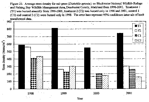
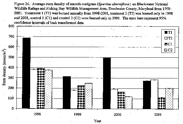
Stem density: Stem density of saltgrass was significantly greater on annual burn sites than on 3-year (p=0.0016), control 1 (p=0.0017), and control 2 (p=0.0005) sites. Average stem density for saltgrass was 2,000 stems/m². Stem density for smooth cordgrass on annual burn sites was significantly greater than on control 1 (p=0.0379), but not 3-year burn (p=0.2697) or control 2 (p=0.1147) sites. Where smooth cordgrass was dominant, stem density averaged 300/m². Stem density for saltmeadow cordgrass on annual burned sites was significantly greater than on control 1 (p=0.0397) sites, but not significantly greater than on 3-year burned (p=0.3842) or control 2 (p=0.3363) sites. Typical average stem density for saltmeadow cordgrass was 2,000/m². Stem densities of saltgrass, smooth cordgrass, and saltmeadow cordgrass on annual, 3-year burn, and control sites are shown in Fig. 23, Fig. 26, and Fig. 27, respectively [1]:

1. Flores, Conception. 2003. Evaluation of vegetative response to fire exclusion and prescribed fire rotation on Blackwater National Wildlife Refuge and Fishing Bay Wildlife Management Area. Princess Anne, MD: University of Maryland Eastern Shore. 326 p. Thesis. [45306]
2. Garrison, George A.; Bjugstad, Ardell J.; Duncan, Don A.; Lewis, Mont E.; Smith, Dixie R. 1977. Vegetation and environmental features of forest and range ecosystems. Agric. Handb. 475. Washington, DC: U.S. Department of Agriculture, Forest Service. 68 p. [998]
3. Kuchler, A. W. 1964. United States [Potential natural vegetation of the conterminous United States]. Special Publication No. 36. New York: American Geographical Society. 1:3,168,000; colored. [3455]