| FEIS Home Page |
 |
Table of Contents:
|
| Figure 1. The 2007 Anaktuvuk River Fire burning in mid-September in moist, acidic tundra in the foothills region of the North Slope, Alaska. Photo courtesy of the US Bureau of Land Management. |
The primary geographic focus of this review is Alaska; however, information from Canadian tundra communities is included to provide a wider perspective. This review does not include information on fire regimes in tundra communities outside of North America. Other literature reviews describing fire regimes of tundra communities are available and were used in this review: [16,19,82,89].
Most fires in tundra ecosystems are caused by lightning in June or July. Fires in tundra communities range from relatively frequent to very infrequent. Fire-return interval estimates for different community types vary from 30 to >1,000 years (Table 1). Fire frequency varies by region, reflecting differences in climate, vegetation, and elevation. Tundra fires are larger and more freqeunt on the Seward Peninsula and in the Noatak River Valley than in other parts of Alaska or Canada. In the Noatak River Watershed, tundra fires were most frequent at low elevations. Although fuels accumulate more rapidly in tundra ecosystems than in boreal forest ecosystems, fires are generally less common in tundra ecosystems than boreal forest ecosystems and intermediate in the boreal forest-tundra ecotone. This is due in part to fewer ignitions in tundra. Tundra fires generally occur during summers that are hotter and drier than average.
Fires in tundra ecosystems range from low to high severity. Fire severity depends in part on the prefire plant community composition, with fires in tussock tundra communities typically less severe than those in scrub birch and ericaceous shrublands. Fires in tussock tundra communities tend to be fast-moving surface fires because the organic soil layer underneath the surface vegetation is typically moist and thus is difficult to burn. During hot, dry years, however, organic soils become dry and burn more deeply, and these ground fires may smolder for weeks to months. Tundra shrublands most commonly burn with stand-replacing crown fires. Dry upland sites typically burn more severely than moist lowland sites. Arctic and alpine tundra communities generally have lower severity fires than boreal forests. Fire timing is likely to affect fire severity in tundra communities, with more severe fires occurring later in the growing season.
Fires in tundra communities often burn discontinuously, resulting in a mosaic of unburned, lightly burned, and severely burned areas. Reported fire sizes ranged from 1 to >250,000 acres (0.4-100,000 ha) (Table 7). However, most fires in arctic tundra ecosystems are small (<120 acres (50 ha)) and restricted to relatively dry sites that have continuous fuels. Climate, terrain, and vegetation strongly influence pattern and extent of tundra fires. Warm, dry weather in summer and early fall explain most of the interannual variability in area burned. The largest fires appear to be those that burn late into the growing season when vegetation has dried. Many researchers noted that river and stream drainages and lakes were sufficient to block fire spread in arctic tundra communities. Other researchers noted that fires stopped at ecotones with moist fuels, for example where tussock tundra intergrades with white spruce (Picea glauca), willow (Salix spp.), and alder (Alnus spp.) communities. Fire size and pattern in arctic tundra is influenced in part by region and elevation, with the largest fires occurring in western-most regions at low elevations.
Appendix A summarizes data generated by LANDFIRE succession modeling for the Biophysical Settings models (BpSs) covered in this review. Due to the scarcity of information in published literature, specific fire regime information is not available for every BpS model. The range of values generated for fire regime characteristics in Alaskan tundra communities is:| Fire interval¹ (years) | Fire severity² (% of fires) |
Number of Biophysical Settings (BpSs) in each fire regime group |
|||||||
| Replacement | Mixed | Low | I | II | III | IV | V | NA³ | |
| 175-1,023 | 98-100 | 0-2 | 0 | 0 | 0 | 0 | 15 | 18 | 62 |
¹Average historical fire-return interval derived from LANDFIRE succession modeling (labeled "MFRI" in LANDFIRE). ²Percentage of fires in 3 fire severity classes, derived from LANDFIRE succession modeling. Replacement-severity fires cause >75% kill or top-kill of the upper canopy layer; mixed-severity fires cause 26%-75%; low-severity fires cause <26%. ³NA (not applicable) refers to BpS models that did not include fire in simulations. |
|||||||||
Because most of the area occupied by tundra in Alaska is sparsely populated and has little road access, current fire regimes in tundra may not differ much from historical regimes. However, human-caused ignitions are more frequent in contemporary than historical times. Human-caused fires tend to be smaller than lightning-caused fires. Arctic and subarctic regions are expected to be disproportionately affected by climate change. Warmer temperatures are expected to lead to a longer snow-free season, changes in vegetation, and loss of ice and permafrost, which in turn are likely to lead to longer fire seasons and increased fire frequency, severity, and area burned.
Due to a scarcity of information, LANDFIRE's Biophysical Settings Models lack information on fire regimes for most of the Alaskan tundra communities included in this review. A lack of fire records hinders knowledge of fire regimes in many communities. Where fire records are available, their quality is often noted as a concern.
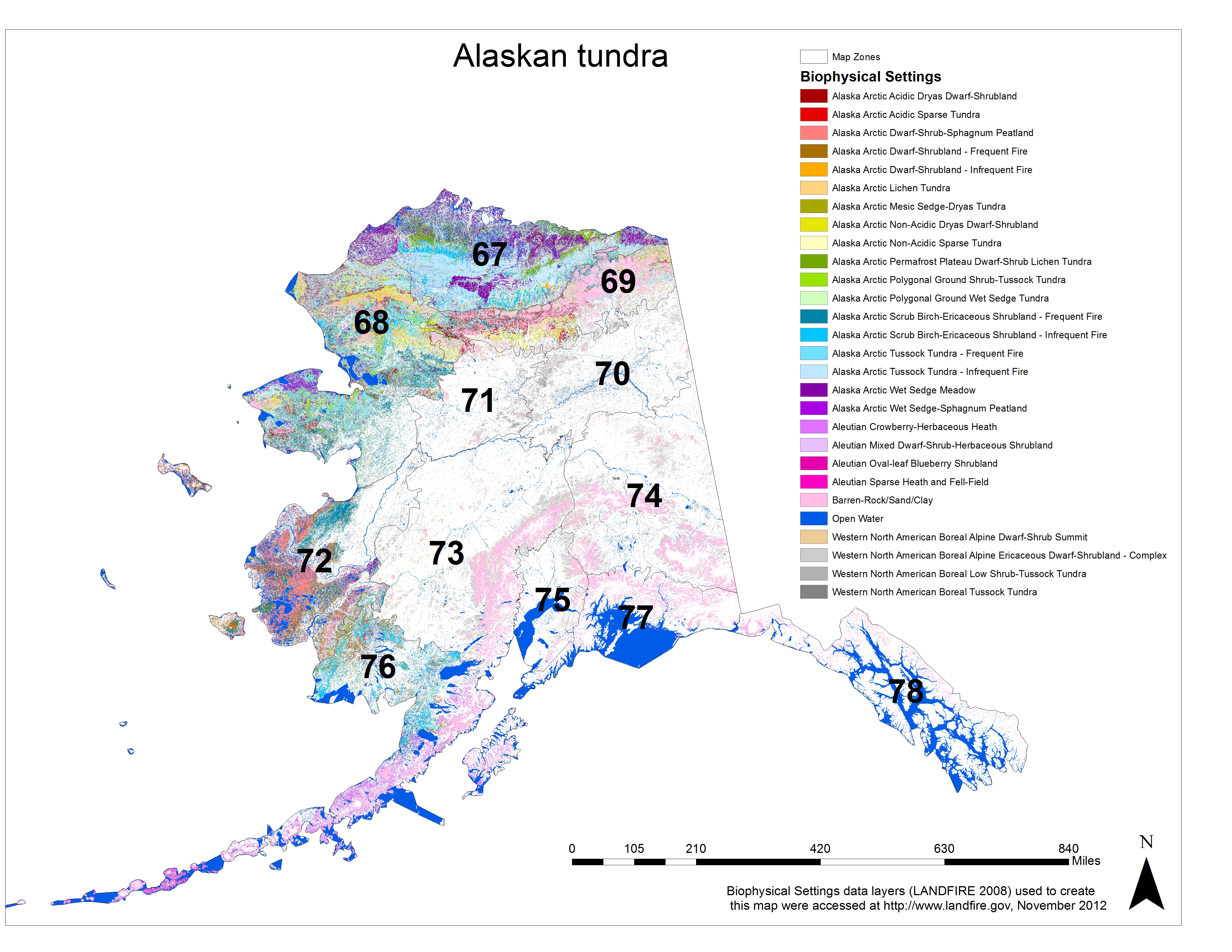 |
| Figure 2. Distribution of tundra landcover within Alaska based on the LANDFIRE Biophysical Settings (BpS) data layer [93]. Numbers indicate LANDFIRE map zones. Click on the map for a larger image and zoom in to see details. |
Vegetation types included in this review are dominated by either tussock-forming sedges (e.g., Eriophorum spp. and Carex spp.), lichens, scrub birch (Betula spp.) and ericaceous shrubs, or dwarf shrubs (Appenidx A). This review discusses fire regimes of these communities in lowland tundra and in upland, including alpine, tundra in Alaska and Canada. Arctic tundra primarily occurs in the northern-most and western-most regions of Alaska beyond the limit of trees. The Arctic is sometimes divided into "low arctic" and "high arctic" regions. Tundra dominates in the low arctic, whereas polar deserts and semideserts dominate in the high arctic [10]. Tundra is also widely distributed throughout interior Alaska in the boreal forest region [10,16,17,79]. Alpine tundra is found at the highest elevations on all mountain ranges of Alaska, on exposed ridges in the Arctic, and in western and southwestern coastal areas [16,19,92]. Within each, a fine-grained mosaic of vegetation types occurs [23].
Tundra and boreal forest communities are intermingled over large areas of Alaska and Canada. Ecotones between boreal forest and tundra occur along longitudinal gradients from west to east, along latitudinal gradients from south to north, and along altitudinal gradients from low to high elevation. The altitudinal transition from forest to alpine tundra tends to be abrupt, whereas the longitudinal and latitudinal transitions from forest to tundra are relatively gradual [16,38,45].
Presence of permafrost plays an important role in organic soil moisture content, plant community composition, and soil organic matter accumulation in tundra ecosystems [56]. Permafrost, or permanently frozen ground, is found throughout Alaska except along the southern coast. Three permafrost zones occur in the state: continuous, discontinuous, and permafrost free. Continuous permafrost occurs on the North Slope, in the Brooks Range, and in most of western Alaska north of the Kuskokwim River. Permafrost is discontinuous in interior and south-central Alaska. Little or no permafrost occurs in the Aleutians, Kenai Peninsula, and along the southern coast [23]. Permafrost, when present, adds rigidity to many soils. However, when it melts, many of these sites become unstable and flow. Permafrost stops root penetration of plants, which keeps the root zone near the soil surface. In addition, permafrost acts as a dam that stops drainage, which forces water to drain over the soil surface and/or to accumulate in peaty material and depressions, forming extensive marshes and lakes [6,23]. The "active layer" is the transition zone located at the uppermost permafrost that alternates in status seasonally between frozen and thawed [46,82]. Seasonal thawing of the active layer in Arctic and Bering tundra typically reaches only 4 to 24 inches (10-60 cm) below the soil surface [6].
Due to geomorphic and freeze-thaw processes, arctic tundra land surfaces are dominated by a variety of patterned ground forms, including polygons and mudboils (i.e., sorted and nonsorted circles and stripes of stones that may be topped by bare mud or with sparse vegetation) that affect plant community composition and distribution [6,8,10,50,56] (see Figures 3-5). Polygons are typical of lowlands, whereas mudboils are typical of uplands [10]. Polygon rims are raised and impede drainage from polygon centers. Thus, standing water remains in many polygon centers well after thaw and in some polygons persists throughout the growing season. On the North Slope, a community of sheathed cottonsedge (Eriophorum vaginatum), northern Labrador tea (Ledum palustre), and a variety of other vascular plants, lichens, and bryophytes occurs on polygon rims, whereas nearly pure stands of leafy tussock sedge (Carex aquatilis) or a combination of leafy tussock sedge and diamondleaf willow (Salix pulchra) occurs in polygon troughs and centers. Thermokarst erosion of low-centered polygons may result in the low, wet centers of polygons becoming high, dry centers when the ice wedges melt under polygon troughs. High-centered polygons may have a vegetation community similar to that on the rims of low-centered polygons, but the tops are often capped with entireleaf mountain-avens (Dryas integrifolia). In such cases, leafy tussock sedge typically covers the surrounding troughs [56].
Plant community composition in tundra ecosystems is influenced in part by soil moisture [7,8,56,85]. Sedge-shrub tundra communities form a continuum from sedge-dominated tundra to shrub-dominated tundra along a moisture gradient, with sedges dominating moister sites and shrubs dominating drier sites. In addition, sedge-shrub tundra can integrate with tussock tundra with the addition of tussock-forming sheathed cottonsedge and/or Bigelow sedge (Carex bigelowii) [7]. Along the moisture gradient from wet to dry, tussock tundra vegetation shows a corresponding shift in dominance from sheathed cottonsedge to Bigelow sedge [8]. For more detailed descriptions of the tundra plant communities discussed here, see the site and vegetation descriptions of individual Biophysical Settings Models listed in Appendix A. Descriptions of ecological systems are available on the NatureServe Explorer website as well as in these sources: [6,10,26,52,56,65,79,84,85].
Fire ignition: Historically, fire in tundra ecosystems was caused by lightning during irregular thunderstorms [16,17,86,89]. Although indigenous people may have started some fires [86], this is thought to have been rare ([53], Rasic personal communication cited in [32]). Air-mass storms with infrequent lightning start most lightning-caused fires in present-day interior Alaska [18]. This was likely the case historically. These storms are infrequent in the Arctic [63]. Racine and others [59] concluded that in most years there is only a brief 1- to 3-day period when conditions for Arctic tundra fire ignition are met, due to the rare occurrence of thunderstorm activity following dry periods of sufficient length to produce burnable fuels.
Frequency of lightning strikes in tundra, and thus frequency of ignitions, is influenced by elevation, albedo, and proximity to boreal black spruce (Picea mariana) forest. Variation in lightning-strike density in interior Alaskan tundra communities (from the Bering Sea east to the Canadian border) from 1986 to 1999 was influenced by the interaction or combination of these factors [18]. Lightning strikes were concentrated at treeline. Above treeline, in alpine tundra, lightning-strike densities decreased. Lightning-strike densities were least in the lowest elevation areas, most of which were coastal tundra and/or shrub communities [18]. The high density of lightning strikes at treeline suggests that alpine tundra would have a high fire frequency due to the spread of fires from subalpine forests into alpine tundra communities [17]. Because fire is infrequent in alpine tundra, researchers concluded that factors other than ignitions, such as the scarcity of fuels, have more influence on fire frequency at high elevations [17,43]. In interior Alaska, albedo affected lightning-strike frequency at a given elevation. Boreal spruce (Picea spp.) forest had a higher lightning-strike density than tundra and shrub vegetation presumably because its dark, structurally complex canopy absorbs more radiation (i.e., it has low albedo) and transfers it to the atmosphere, fostering convection and the formation of air-mass thunderstorms [17,18]. The highest lightning-strike densities in coastal tundra tended to fall within 6 to 16 miles (10-25 km) of the boreal forest-tundra boundary [18]. Researchers in Canadian tundra regions reported that lightning-caused ignitions were more common with increasing aerial cover of black spruce trees [18,28,54,55,63,71]. However, in the Noatak River Watershed, where white spruce but not black spruce trees occur within tussock tundra and low arctic shrublands, there was no evidence to suggest that fires in tundra communities were concentrated near forests [59].
Fire season: In tundra ecosystems throughout Alaska, fires may start from May through August, although most fires start during a short period from June through July [17,59,63,89]. Fires can be ignited as soon as snow melts and vegetation dries [86,89]. Fires are typically extinguished by late summer rains [17], but some researchers reported fires burning into September and October (see Fire timing) (e.g., [27,39,41]).
Fire frequency: Studies providing information on fire-return and fire-rotation intervals in tundra ecosystems generally do not differentiate among plant communities. In general, fires in tundra communities range from relatively frequent to very infrequent. Mean fire-return intervals in tundra ecosystems ranged from 50 to >1,000 years (Table 1). Mean fire-rotation intervals in tundra ecosystems ranged from 221 to >10,000 years (Table 2). Reports of areas in tussock and shrub-tussock communities that burned 2 or more times during the late 1900s and early 2000s suggest that short fire-return intervals are common in some areas of tundra in Alaska (Table 3). During the late Pleistocene and early- to mid-Holocene (13,300-10,300 years BP), fires in shrub tundra communities were relatively frequent, with return interval estimates ranging from 137 to 150 years (Table 4). However, the tundra biome during this period was likely shrubbier than modern tundra (dominated by tall, resinous birch and lacking alder) and existed under climatic conditions that were likely cooler and drier than present, making the community more conducive to fire spread than modern tundra [30,32].
Fire frequency in the tundra biome varies by region [16,29]. The main dichotomy is between tundra communities on the Seward Peninsula and in the Noatak River Watershed, which have mean fire-return or fire-rotation intervals between about 140 and 700 years [24,29,32,40,43,59], and tundra communities to the north and south, which have mean fire-return or fire-rotation intervals >1,000 years [24,34]. Tundra fires are more common and larger on the Seward Peninsula than in other parts of Alaska and northwestern Canada [24,38,40,57,59]. The frequency and extent of tundra fires in the Noatak River Watershed was much greater than in other tundra regions to the east and north but less frequent and smaller than fires on the Seward Peninsula [59]. On the Seward Peninsula, the frequency of lightning-caused fires from the 1960s to the 1980s was 11.9 fires/5,000 km², while it was 7.3 fires/5,000 km² in the Noatak River Watershed and 0.4 fires/5,000 km² in the Kokolik River area on the North Slope [60]. Lightning-caused fires in tundra ecosystems on the Alaska Peninsula and the Aleutian Islands are rare [24], with only 3 fires reported in these regions. These occurred in crowberry (Empetrum spp.) heath and crowberry meadow communities on Amchitka Island [82]. The distribution and dates of recent fires in northern Quebec along a south-north transect from the boreal forest north to the arctic shrub tundra, showed that the frequency, number, and size of fires decreased progressively north [55]. Fires in the Canadian Arctic Archipelago have not been reported. In this region, fuels are likely too sparse and discontinuous to carry a fire (see Fuel biomass and continuity) [28].
Regional differences in tundra fire regimes in Alaska are due in part to differences in climate, elevation, and vegetation [16]. On the western coast of Alaska, where fire in tundra communities is most frequent, the climate is transitional between the warm, dry continental climate of interior Alaska and the warm, wet maritime climate along the southern coast. The climate on the northern coast of Alaska is substantially colder than in other regions [16,34,40]. On the Seward Peninsula and parts of northwestern Alaska from 1950 to 2007, burned areas only covered 9.2% of the tundra ecosystem, but 7.0% of that area had burned 2 or more times during that period. The authors reported 12 cases in tundra communities where a patch had burned more than once. The high incidence of reburning in the region was attributed to the warm, dry continental interior climate [40]. The location of 232 tundra fires in Alaska occurring between 1950 and 2005 was significantly skewed to tundra regions with relatively dry and/or warm summer climates, specifically those with mean June precipitation between 0.79 and 1.18 inches (20–30 mm) and mean June temperature between 43 and 50 °F (6-10 °C) (P<0.01) [30]. Along a 30-mile (50 km) transect in the Noatak National Preserve, northwestern Alaska, in an area with a mosaic of tussock-shrub tundra, scrub birch-ericaceous shrub tundra, and willow-shrub tundra with white spruce, western "down-valley sites" located at Raven and Uchugrak lakes had shorter mean fire-return intervals (142 years) than those of more eastern, "up-valley sites" located at Poktovik and Little Isac lakes (263 years) during the period between 6,000 years BP and 2007 (Table 1). The difference was attributed to lower growing season temperatures and greater precipitation at up-valley sites that limited fuel drying and thus lowered the probability of fire ignition and spread [29,32].
Elevation influences fire frequency. In western Alaska, tundra fires were most frequent at low elevations. Most lightning-caused fires recorded in the Noatak River Watershed between 1956 and 1983 were located in close proximity to the valley floor. The mean distance of all fires from the Noatak River was 9 miles (14 km). The upper elevational limit of fire appeared to be 1,480 to 1,970 feet (450-600 m) and generally corresponded with the upper limit of tussock and shrub-tussock tundra vegetation types. The fire-rotation interval was estimated at 998 years for the entire watershed but it was only 221 years for elevations below 980 feet (300 m) (Table 2) [59]. In interior Alaska (in 9 non-coastal ecoregions), a study of fire-rotation intervals in forest and tundra communities found that fire-rotation intervals at the lowest elevations (<660 feet (200 m)) were longer than those at midelevations (660-1,300 (400 m)) but shorter than those at the highest elevations (>1,300 feet) [43].
Vegetation type influences fire frequency. Fuels accumulate more rapidly in tundra ecosystems than in boreal forest ecosystems [40]. However, fires are generally less common in tundra ecosystems than boreal forest ecosystems and intermediate in the boreal forest-tundra ecotone. The difference is attributable in part to less frequent ignitions [16,17,28,55,89]. Grasses and sedges that dominate many tundra ecosystems recover very quickly after fire and produce surface fuels (dead leaf litter) that can carry new fires, whereas surface fuels (dominated by feather mosses) in boreal forest can take decades to return to prefire or control levels [40]. Reburning in tussock and shrub-tussock tundra communities has occurred from as little as 5 or 6 years after fire (Table 3) [27,29,40,59]. The relative number of fires per year in northern Quebec from 1920 or 1930 to 1984 was 0.41 fire/year in shrub tundra, 0.44 fire/year in northern forest-tundra, 0.60 fire/year in southern forest-tundra, and 0.72 fire/year in northern boreal forest [55]. Vegetation flammability may influence fire frequency in tundra ecosystems. DeWilde and Chapin [17] categorized 4 fuel types in interior Alaska and ranked them in order of decreasing flammability as: boreal spruce>mixed hardwood/spruce >>open tundra, shrub/grass=boreal lichen. The "open tundra, shrub/grass" fuel type consisted of open tundra, which was considered to have generally low flammability because of high moisture content and small fuel loads, and grass meadows, which were considered very flammable in spring because of dry leaf litter, but less flammable during the growing season because of high leaf moisture content. Boreal forest was considered the most flammable because of its fine twigs and needles, high resin content, low moisture content, and ladder-like structure that carries fire into the canopy [17]. For more information about fuels characteristics, see Fire severity. See also FEIS reviews of plant species of interest (e.g., Appendix B).
Tundra fires occur during summers that are hotter and drier than average (e.g., [25,30,34,41,43,47,55]). In tussock and shrub-tussock tundra in the Noatak River Valley, 79 fires occurred during 28 years, although fires occurred in only 12 of the 28 years. In years when fires occurred, the number of fires ranged from 1 to 25 fires/year. The authors concluded that tundra fires in the low arctic tundra of the Seward Peninsula occurred during summers with lower than average rainfall and higher than average temperatures [59]. On the Seward Peninsula and parts of northwestern Alaska there were 15 large fire years from 1950 to 2007, where the cumulative annual burned area in the region, which was a mosaic of tundra and boreal forest, was >200,000 acres (81,000 ha). All but one of these large fire years (1969) had average August temperatures >53 °F (12 °C); in 1969, June precipitation was the lowest on record. Large fire years occurred every 16.3 years on average (see Fire size) [40]. The largest recorded fire on the North Slope, the 250,000-acre (100,000 ha) Anaktuvuk River Fire (Figure 1), occurred during a year (2007) with the most extreme moisture deficit (precipitation minus evapotranspiration) on record and the highest mean June to September temperature on record [34]. Although 4 fires were recorded on the North Slope during 2007, only 18 other fires had been reported in the region during the 56 previous years [41].
Fire effects on plants: Fire frequency in tundra communities depends in part on the plant community and its rate of fuel accumulation [19,21,59,82,90]. Many plant species that make up tundra ecosystems have adaptations for survival in fire-prone ecosystems and recover quickly after fire [5,19]. Recovery of graminoids, such as cottonsedge and sedge, is typically rapid after a fire that does not kill underground plant parts, whereas recovery of some bryophytes such as sphagnum moss (Sphagnum spp.) and fruticose lichens (e.g., Cladonia spp.) is slow. Recovery of shrubs is intermediate: Although shrubs like northern Labrador tea and dwarf birch (Betula nana) sprout readily after fire, they typically take longer than graminoids to reach prefire or unburned control levels after fire. Vascular plant recovery following relatively small, low- or moderate-severity fires generally requires <25 years. Sphagnum moss and lichens may establish within the first few years after fire, but their slow growth limits their abundance for at least the first 25 to 30 postfire years. On severely burned sites, lichen recovery may take >100 years [5,10,11,19,21,35,36,37,39,45,57,58,60,61,62,72,78,82,90]. Cooler growing seasons in the Kokolik River on the North Slope may result in slower rates of plant regrowth than at the Noatak River and Seward Peninsula sites [60], thus leading to slower rates of fuel accumulation. For sources of information about fire effects on plant species that occur in tundra communities, see Appendix B.
Rate of vegetation recovery in tundra communities may be influenced by fire severity. If the fire stays on the surface and does not consume the organic soil layers, then some plants will sprout the following spring. It may take decades or even centuries to revegetate a burned area after a severe fire that consumes peat and organic soils [51]. Rate of vegetation recovery during the first 2 postfire years in wet sedge-cottonsedge meadows in Nunavut appeared to be faster than that in mesic areas, apparently because wet peats protected underground plant parts. In these communities, vegetative regeneration occurred immediately after fire. However, recovery appeared more variable in mesic bog birch-heath communities with high moss and shrub cover. Growth of shrubs such as bog birch, bog blueberry, mountain cranberry (Vaccinium vitis-idaea), and marsh Labrador tea (Ledum palustre subsp. decumbens) appeared to be slower in areas with higher burn severity. Where the peat layer was completely consumed by fire, growth of plants was very sparse or absent [91]. One year after a 1977 wildfire on the Seward Peninsula, revegetation in tussock-shrub tundra was rapid, mainly as a result of tussock sprouting, but was much slower in drier, low shrub areas where organic soils were largely consumed by fire [57]. Wein and Bliss [90] studied fire effects on 4 arctic sheathed cottonsedge communities in Alaska and the Northwest Territories. Some communities had scattered black spruce and others were treeless. The communities occurred in a matrix of marsh Labrador tea, mountain cranberry, bog blueberry, bog birch and/or dwarf birch. They found that plant recovery following fire was greater in areas with peat and moss mats because they protected the growing points of sheathed cottonsedge [90]. For more information, see Fire severity.
In the absence of fire or other disturbance for long periods, plant succession may alter fire regimes in tundra ecosystems. Racine [58,60] proposed a hypothesis for the role of fire in sedge tussock-shrub tundra. He stated that without fire or other disturbances such as frost action, cottonsedge tussocks become colonized by dwarf shrubs, mosses, and lichens. Over time, dwarf shrubs and mosses eventually grow up and around the cottonsedge tussocks. These growth forms eventually replace the tussocks, resulting in the senescence of tussocks and thinning of the active layer and thus raised permafrost levels and reduced frost action. He stated that fire would reduce these successional trends by reducing vegetation and organic soil around tussocks and increasing tussock growth and reproduction, unless succession had progressed "so far" and/or fire had burned "so hot" that there was no tussock recovery. Frost action processes might also be renewed if enough organics were burned off that thaw depths reached into the mineral soil [58,60].
Fire effects on soils: Fires can produce a wide range of changes in tundra soils, which may have long lasting effects on tundra plant communities (See Fire effects on plants). Immediate or short-term effects include removal of litter and plant biomass, darkening of the soil surface, increased soil temperature, increased depth of summer thaw, increased soil moisture levels, and release of nutrients [10,46,48,50,57,72,80,90]. It may take decades for soil characteristics to return to prefire or control conditions [80]. The 1968 forest-tundra fire near Inuvik, removed the vegetation canopy, reduced heat loss from evapotranspiration, and lowered the surface albedo by burning the organic cover. As a result, the active layer on most sites deepened. At all sites where the active layer deepened, the ground surface subsided from the thaw of ice-rich permafrost. The addition of thaw water to the bottom of the active layer on poorly drained sites created moist conditions that favored vegetation growth. The vegetation growth shielded the ground surface, and by postfire year 25, active layer depths had decreased to unburned control levels, permafrost had aggraded upward, and there was some ground uplift from the growth of aggradational ice [50]. One to 4 years after the severe Kougarok area fire on the central Seward Peninsula, the active layer deepened on a burned tussock tundra area compared with prefire and control areas. This was attributed to increased near-surface soil temperatures, which increased heat conducted into the ground during summer and increased soil moisture levels. Surface albedo was reduced after the fire because the combustion of lichens and mosses exposed tussock bases and increased surface roughness. This may have reduced the possible magnitude of soil temperature change after fire [46]. Wein and Bliss [90] studied fire effects on 4 arctic sheathed cottonsedge communities in Alaska and the Northwest Territories. Some communities had scattered black spruce and others were treeless. The communities occurred in a matrix of marsh Labrador tea, mountain cranberry, bog blueberry, bog birch and/or dwarf birch. They found that the active layer depth increased by 35% to 59% in June and by about 25% in late autumn 1 year following fires. Variation in thaw depth was related to the surface conditions following fire, especially to the amount of organic material remaining after fire. One year after a 1977 wildfire in a coastal tundra community on the Seward Peninsula that removed 2 to 6 inches (5-15 cm) of the peat surface layer, the depth of thaw on burned sites reached to the mineral soil, whereas prior to the fires it did not [57]. One month following the Kokolik River area fire on the North Slope, the active layer was 13.9 inches (35.4 cm) thick on burned areas compared with 10.5-inch (26.6 cm) thick on adjacent unburned tundra [25]. Active layer thicknesses increased at all burned plots for 2 years and remained deeper at severely burned plots than control plots for at least 3 years following the fire. Melting and subsidence of ice wedges also occurred [37].Fire type: Unlike boreal forest, where creeping ground fires are common [63], fires in tussock tundra and lichen tundra communities tend to be fast-moving surface fires because the organic soil layer underneath the surface vegetation is typically moist and thus does not readily burn [2,48,89]. During hot, dry years, however, organic soils become dry, burn more deeply, and may smolder with ground fire (e.g., [41,58]). Stand-replacing crown fires appear common in ericaceous, birch and ericaceous, and dwarf shrublands [25,37,58]. Racine [58] described a birch and ericaceous dwarf shrub tundra community on the Seward Peninsula where all of the aboveground vegetation burned during a fire, but only about 50% of the organic mat burned (Table 5). For more information, see Fire severity.
Fire severity: Fire severity in tundra ecosystems depends upon the plant community, fuel characteristics, terrain, moisture content of organic soils, and season of burning. In LANDFIRE's Biophysical Settings Models of fire regimes, fire severity is defined by the percent of the upper canopy layer removed by fire. However, most studies of fire in tundra communities do not provide this information. Limited quantitative data and qualitative information provided by researchers indicate that fires in dry to mesic, upland tundra communities may be stand replacing, with >75% of the upper canopy layer removed, whereas fires in lowland, poorly drained sites or in alpine tundra communities may be of mixed severity, with 26% to 75% of the upper canopy layer removed, or low severity, with <25% of the upper canopy layer removed by fire [11,19,25,37,41,57,58,82].
Researchers describing fire severity in tundra ecosystems generally describe it based not only on the amount of aboveground vegetation removed by fire, but also on the amount of the soil organic layer consumed by fire and fire effects on vegetation occurring within the first 1 or 2 years after fire (e.g., [25,27,41,46,58,61,62]). Based upon this assessment of fire severity, tundra fires are typically of low or moderate severity, with no vascular plant species completely killed by fire. However, severe fires also occur occasionally (e.g., [2,4,11,11,46,57,61,62,77,82]). For example, 47% of the 250,000-acre (100,000 ha) Anaktuvuk River Fire was classified as high to "extreme" severity, while 35% was classified as moderate to high severity, and only 18% was low to moderate severity. Burn severity was classified using satellite imagery from 8 years before the fire and 1 year after the fire. Low-severity burned sites were those with a mixture of burned, unburned, and regenerating patches of vegetation. Moderate-severity burned sites were those that were mostly burned but with some vegetation remnants and minimal tussock regeneration. High- to extreme-severity burned sites had complete vegetation removal and partial organic soil consumption. The fire occurred primarily in the Arctic Foothills physiographic province of the North Slope; the ecosystem was described as upland, moist, acidic tundra characterized by tussock-forming sheathed cottonsedge and Bigelow sedge, with >25% cover of dwarf shrubs, especially northern Labrador tea, dwarf birch, and mountain cranberry [41]. One year after the fire, survivorship of sheathed cottonsedge tussocks across the burned area was high, averaging 87%, while mosses, lichens, and dwarf shrubs that inhabited spaces between tussocks before the fire were almost completely killed [48]. A nearby fire, the Kuparuk River Fire, remained small at 1,791 acres (725 ha), and 80% was classified as low severity, 20% as moderate severity, and 1% as high severity. Differences in burn severity were attributed in part to the fact that woody scrub species comprised the majority of the high-severity burned areas, and these species were more prevalent in the region of the Anaktuvuk River Fire [41].
Fire severity is influenced by site characteristics and prefire plant community composition. In the 1977 Seward Peninsula fires, all aboveground parts of shrubs were typically killed by fire, regardless of site characteristics, but the amount of soil organic matter removed by fire was related to prefire plant community composition and topography [57,58]. For example, Racine [58] determined fire effects in several tundra communities on Nimrod Hill after the 1977 Imuruk Lake Fire on the Seward Peninsula (Table 5). Burn severity was consistently higher in birch and ericaceous shrub tundra communities than other communities because of their more xeric topographic position and the absence of "fire-resistant" sheathed cottonsedge tussocks in these communities. Some authors described fires as being more common but less severe in tussock tundra communities than birch and ericaceous shrub communities (e.g., [5,16,36,37,41,46,57,58,60,86]). In the Noatak River Watershed in northwestern Alaska, on the Seward Peninsula, and in the Kokolik River area on the North Slope, sheathed cottonsedge tussock tundra appeared to be the major vegetation type that burned during fires in the 1970s. The authors suggested that this was due to the flammability of the accumulated dead leaves of sheathed cottonsedge [60]. All tundra vegetation types burned in the 1977 Seward Peninsula Fires; sedge tussock-shrub tundra was the most widespread and most frequently burned, whereas wet sedge meadows, closed tall willow shrublands, and open mat and cushion tundra were usually unburned. Closed mat and cushion tundra, however, often burned patchily on dry sites. Sedge tussock-shrub tundra had a "fairly large component" of low shrub heaths and dwarf birch. The birch and ericaceous shrub tundra communities occurred in association with sedge tussock tundra on moist sites, with sedge-shrub tundra on wet sites, or alone on drier sites. Burning was generally less severe in the tussock-shrub and sedge-shrub tundra communities than in the birch and ericaceous shrub tundra. In sedge tussock-shrub tundra, the thick organic peat layer remained largely intact after fire, and small unburned patches were common. The most severe fires occurred on well-drained sites with birch and ericaceous shrub tundra and closed dryas (Dryas spp.) mat and cushion tundra communities that occurred on the brows of hills and the tops of some raised, high-centered polygons [57].
A review considered the low ericaceous shrubs (e.g., crowberry, Labrador tea (Ledum spp.), and blueberry (Vaccinium spp.)) the most important determinant of flammability in lichen-dominated tundra and forest-tundra communities because of their low temperature for ignition, high heats of combustion, and abundant and continuous fine fuels [5]. Sylvester and Wein [73] studied the fuel characteristics of common arctic tundra and forest-tundra species and genera near Inuvik and ranked them in order of decreasing flammability as: dead leaves of graminoids (sheathed cottonsedge and bluejoint reedgrass (Calamagrostis canadensis))>evergreen ericaceous shrubs (northern Labrador tea and black crowberry (Empetrum nigrum))>fruticose lichens>dwarf deciduous woody shrubs (bog birch (Betula glandulosa), bog blueberry (Vaccinium uliginosum), and grayleaf willow (Salix glauca))=sphagnum moss>fireweed (Chamerion angustifolium) [73]. In a study of 1- and 2-year-old tundra burns in the Hudson Bay area of Canada, black lichen (Alectoria) communities were completely burned, whereas fruticose lichen (Cetraria spp.) communities burned "less readily", and mixed lichen-dwarf heath communities burned "irregularly". Wein [86] noted that bog birch-heath tundra communities were "particularly susceptible to fires", while sphagnum moss-dominated tundra communities appeared to be "much less susceptible". Wein [88,91] stated that most tundra communities will burn except for those with standing surface water or those with sparse cushion plants.
Dry upland sites typically burn more severely than moist lowland sites [25,27,37,61,62,90]. Fires in cottonsedge tussock tundra types in areas with wet soils tend to be low severity [87]. In a late July to mid-August 17-mile² (44 km²) wildfire in arctic tundra in the Kokolik River Watershed on the North Slope of Alaska, all areas of raised relief, which consisted of sheathed cottonsedge tussock tundra, were severely burned and averaged <10% live vascular plant cover immediately after fire. The high severity of the fire in this community was attributed to dry soils and the presence of more fuels (litter and standing dead vegetation) on upland sites. In contrast, irregularly distributed areas of low relief with wet soils (i.e., wet sedge-shrub communities that occurred in shallow drainage depressions dominated by leafy tussock sedge, tall cottongrass (Eriophorum angustifolium), and diamondleaf willow) were either moderately burned, averaging 30% live plant cover, or lightly burned, with 40% live pant cover (Table 6). Small patches of dryas mat and cushion tundra were largely unburned [37]. The authors noted that all shrubs were completely top-killed by moderate to severe fire [25,37]. Vegetation growth on most burned plots was rapid during the first 2 to 3 postfire summers, then slowed substantially (Table 6). Plant species composition on most burned plots remained very different from unburned controls for at least 5 postfire summers, due to lower cover of shrubs and lichens [37]. Although the proportion of organic soil matter consumed was not recorded in this study, mineral soil exposure in the burned area generally "did not constitute a high percentage of the total area". Mineral soil cover was 52% greater on severely burned plots than unburned control plots immediately after fire, in part due to the combustion of the plants and the thin layer of litter covering the edges of frost scars and mudboils [25,37]. On Nimrod Hill in the Noatak River Valley, fire generally consumed more vegetation and organic soil on the steep, well-drained backslope and less on poorly drained downslope and hill crest sites [62]. A shrub tundra site on a well-drained sandy beach ridge burned with moderate severity; a 2.4-inch (6 cm) thick organic horizon was charred to 0.2 inch (0.5 cm) deep. Fire in a low-lying site dominated by polygons with generally low centers outlined by raised hummocky ridges burned mainly along the raised edges where shrubs were common, leaving the lower center portions unburned or lightly burned. On a sheathed cottonsedge slope with scattered grayleaf willow above a wet swale, burn severity was relatively low [61]. According to expert opinion, mesic sedge-dryas tundra sites would likely burn with adjacent sedge tussock tundra, but the wetter sedge-willow tundra sites likely would not carry fire (Arctic Modeling Meeting 2008 personal communication cited in [44]).
Racine and others [60] hypothesized that infrequent fire may contribute to increased fire severity on the North Slope. In the Kokolik River area on the North Slope, longer intervals between fires may have accounted for a greater buildup of fuels and more severe burning when fires occurred [60].
Arctic and alpine tundra communities generally have lower severity fires relative to boreal forest [2,11,20]. Arctic tundra fires are generally less severe than boreal forest fires because the combustible biomass is less, and the cold, wet soils usually prevent deep burning of peat and organic soils [11]. Based on organic matter consumed and plant survivorship immediately or 1 year after fire in Noatak, Bering Land Bridge, Denali, and Yukon-Charley national parks, tundra had the lowest ground burn severity when compared with white spruce, black spruce, and deciduous forests. The authors stated that this was not surprising because of the rapid fire spread (less smoldering) and the generally mesic sites where tussock tundra occurs [2]. In Yukon-Charley National Preserve, specifically, the 1986 Eureka Creek Fire burned upslope in boreal forest but then burned out above the treeline, within the alpine shrub-tundra zone. The alpine shrub-tundra zone generally burned at low severity, presumably because of sparse fuels above the treeline. Burn severity was determined using satellite imagery and was based upon differences in vegetation immediately prior to the fire and 16 years after the fire [20].
Fire timing: Fire timing is likely to affect fire severity in tundra communities. Wein [89] described a lightning-caused fire in arctic tundra that started on 13 June and burned in spite of patches of snow in depressions and the leeward side of shrubs. The fire burned only the standing vegetation because the surface soil was saturated. The author hypothesized that fires occurring later in the fire season under drier conditions would consume more surface organic matter and kill more plant parts than fires occurring earlier, so that regeneration of the plant community would be slower in plant communities burned late in the fire season [89]. In the Kokolik River area on the North Slope, burning appeared to have been more severe when the fires occurred later in the growing season when thaw and water tables would have been deeper [60]. In arctic tundra in the Noatak River Watershed from 1956 to 1983, burned areas were visible on satellite imagery for up to 3 years following fire but could not be seen in the 4th postfire year. July fires were visible on satellite imagery for 3 years following fire, whereas June fires were not. This suggested that the June fires were less severe, perhaps because they occurred when the depth of thaw was shallow and soil moisture levels were high [59].
Rate of fire spread: Most fires in tundra ecosystems spread rapidly (e.g., [27,49,50,63]). In the Inuvik Forest District, a lightning-caused fire in tundra spread "rapidly" over open tundra because of wind across the open area [63]. Mackay [49,50] noted that the 1968 Inuvik Fire swept through burned sites so rapidly, often within minutes, that the time was too brief for the fire to increase the depth of thaw measurably. Shilts (1975 cited in [89]) observed a tundra fire moving rapidly across sedge meadows, and 1 fire that burned at a rate of 3 feet (1 m)/minute against a 10 to 15 km/hr wind. However, researchers occasionally described tundra fires as burning slowly (e.g., [27,69]). An August to September wildfire near Kaminak Lake, Nunavut, burned "slowly and at high temperatures" (Image 4) [69] across an alluvial flat in low arctic tundra where dried grasses and sedges from previous growing seasons provided abundant fuel. During that year, daily temperatures were above average in June and July and "there was little precipitation" [70]. For more information, see Fire type.
The rate of fire spread in tundra ecosystems appears to be related to plant phenology and its effects on fuel flammability. The "mean burn rate" of the 2007 Anaktuvuk River Fire that burned from 16 July until the beginning of August was considered slow at 153 acres (62 ha)/day. It continued to grow slowly until early September, at which point the fire expanded rapidly, burning 17,300 acres (7,000 ha)/day. The dramatic change in fire growth rate was associated with the period when vegetation neared complete senescence as well as a period of mild but persistent southerly winds. Fire growth slowed in late September but continued until 10 October when the fire was extinguished by snow. Three other fires recorded during that year did not persist into the period of vegetation senescence and were smaller [41]. Mack (personal communication cited in [83]) commented that the Anaktuvuk River Fire burned shallowly, sweeping across the landscape, rather than "smoldering down" like peatland fires in other areas. Despite wide variation in prefire soil organic layer depth (range: 4.8-17.0 inches (12.3-43.3 cm)), the depth of soil organic matter consumed by the fire (mean: 6.1 cm) was relatively constant across sites. Overall, ≥4.7 inches (12 cm) of unburned organic soil remained on top of the permafrost in the region after the Anaktuvuk River Fire. The amount of organic soil burned represented on average about 37 years of organic matter accumulation and no more than 50 years. Unlike peatland organic soils in subarctic and temperature ecosystems, cool, moist peats in tundra ecosystems are underlain by permafrost that may restrict burning to plant litter and aboveground biomass (see Fire effects on soils) [48].
Fire intensity: Little has been reported in published literature about fire intensity in tundra communities. Some calculations made by Hill (1969 cited in [89]) indicated that the August high-severity [45] 1968 Inuvik Fire that burned in the forest-tundra ecotone [82] in the lower Mackenzie River region of the Northwest Territories [45,49] traveled about 2 km/day in tundra and 3 km/day in forested areas. Using these data, Van Wagner [77] estimated that fuel consumption during the Inuvik Fire was probably about 0.5 kg/m² and that at a rate of spread of 10 feet (3 m) per minute, the fire would have had an average intensity of about 500 kW/m, "a gentle fire indeed by boreal forest standards".
 |
 |
 |
|
| Figure 3 (left). An aerial view of a 1973 tundra wildfire near Kaminak Lake, Nunavut, shortly after being extinguished. This glacial till plain is densely ornamented with mudboils. The rims of many of the mudboils have burned, while the centers were unburned, leaving behind a ring of boulders, ash, and baked fine sediments. Photo courtesy of Ross Wein, Natural Resources Canada, Geological Survey of Canada [68]. | |
| Figure 4 (top right). A ground view of the burned mudboils shown in Figure 3 [67]. The centers of mudboils are mineral soil with only scattered plants [91]. The turf fringes around the mudboils were 0.5- to 1.0 m-tall ridges of vegetation which enclosed and hid the boulders that were exposed by burning. The burned borders of the mudboils now form depressions, along which surface drainage is focused. Photo courtesy of William Shilts, Natural Resources Canada, Geological Survey of Canada [67]. | |
| Figure 5 (bottom right). A close-up view of a burning turf ring around a mudboil. This fire burned "slowly and at high temperatures". Photo courtesy of William Shilts, Natural Resources Canada, Geological Survey of Canada [69]. | |
Fire pattern: Climate, terrain, and vegetation strongly influence the pattern and size of fires in tundra communities [2]. Fires in tundra communities often burn discontinuously, resulting in a mosaic of unburned, lightly burned, and severely burned areas (e.g., [2,27,46,57,58,89]). Racine [57] described the 1971 and 1977 Seward Peninsula fires as generally patchy with unburned patches within burned areas and with <50% of the organic soil layer removed. The 2002 Kougarok River area fire resulted in severe (i.e., soil organic material completely or nearly consumed down to the mineral soil) to moderate (organic layer partially consumed) burns with a few unburned patches [46]. Near Kaminak Lake, Nunavut, turf rims surrounding mudboils burned but their centers were left unburned, resulting in a mosaic fire (Figure3) [68].
Fire size: Although most fires in tundra communities are small (<120 acres (50 ha)), burned area may exceed 250,000 acres (100,000 ha) (Table 7) [17,24,41,55,82,88].
Years with large fires occur relatively frequently in tundra ecosystems on the Seward Peninsula. From 1950 to 2007, tundra fires >200,000 acres (81,000 ha) occurred at average intervals of 16.3 years [40]. On the North Slope, large fires are comparatively rare: 1% of the North Slope burned from 1950 to 2010, with 68% of that occurring in the Anaktuvuk River Fire of 2007 alone [32,41]. Large fires are most likely to occur during years of warm, dry weather. Warm, dry weather in summer and early fall explained 95% of the interannual variability in tundra area burned throughout Alaska over 60 years [34]. From 1969 to 1975, the largest fires in tundra communities near Inuvik, Northwest Territories, east of the Mackenzie River Delta, occurred during dry years. For example, 98,800 acres (40,000 ha) and 28,400 acres (11,500 ha) of tundra burned as extensions of forest-tundra fires during the drought years of 1954 and 1968, respectively [88].
The largest fires burn late into the growing season when vegetation has dried. Studies in boreal forest regions in Alaska suggested that years with large total burned area were those that had large fires occurring late in the growing season [41,43]. The largest fire in the Arctic Foothills physiographic province of Alaska, the 2007 lightning-caused Anaktuvuk River Fire, burned >250,000 acres (100,000 ha) of moist, acidic tussock tundra [41]. The fire burned into late September even when small lakes had already frozen [39]. The conditions considered responsible for this large tundra fire included record high summer temperature and record low summer precipitation that led to extremely dry soil conditions throughout the summer, particularly during the period of vegetation senescence. During the same year, 3 nearby tundra fires burned <2,500 acres (1,000 ha) combined, and none of them burned into the period of vegetation senescence [41]. In interior Alaska from 1956 to 2000, the largest lightning-caused fires started in June and July, after soils had dried from snowmelt. Those that started in August or September remained small because late summer rains quickly extinguished them [17].
Fire sizes and patterns in arctic tundra are influenced in part by terrain features. Many researchers noted that river and stream drainages and lakes were sufficient to block fire spread in arctic tundra [25,41,45,59,89,91]. On the North Slope, Hall and others [25] noted that streams bordering an arctic tundra fire on the north and east had formed natural fire barriers. The 2007 Anaktuvuk River fire on the North Slope was confined by drainages [41]. Of the Noatak River Watershed fires occurring from 1956 to 1983, about 25% of the fires burned to the banks of the Noatak River, but none jumped the river [59]. Wein [89] commented that an August arctic tundra fire near Inuvik was blocked by polygon cleavages and small streams where wet understories did not carry fire. He further noted that while lowland areas of polygons usually burned, a few raised polygons were protected from fire where the surrounding trenches were sufficiently deep [86,89]. Wein [89] stated that fuels influenced a fire's ability to jump terrain features. For more information, see Fuel biomass and continuity. In Canada from the Hudson Bay to the Yukon border, regions with abundant lakes tended to have less burned area [75].
Some researchers noted that tundra fires stopped at ecotones with moist fuels [59,89]. In the Noatak River Watershed, the entire western margin of a 177-mile² (458 km²) 1977 fire was stopped at the edge or a short distance into a white spruce forest possibly due to a moist understory or to a change in fuel types [59]. In a study of 50 lighting- and human-caused fires occurring in arctic tundra from 1954 to 1973 west of Hudson Bay, white spruce, willow, and alder located along stream channels survived fires in the tundra-forest ecotone because their wet understories did not carry fire. In addition, narrow bands of lakeside sedge communities usually did not burn [89]. According to experts, sedge-dryas communities would likely burn with adjacent tussock tundra, but wetter sedge-willow communities likely would not carry fire (Arctic Modeling Meeting 2008 personal communication [44]).
Fire sizes and patterns in arctic tundra are also influenced by region, tree cover, and elevation. In Canada from the Hudson Bay to the Yukon border, burned area generally decreased from the northwest to the southeast. In the northwestern part of the study region, high cover of continuous mature white spruce forest and scarcity of lakes in the forest-tundra ecotone may have accounted for the extensive burned area. In the southeastern half of the study region, the northern limit of fires typically did not extend beyond the line where tree cover equaled upland tundra cover. Apparently, tree cover constrained fire in this region [75]. For more information, see Fire ignition. In the Noatak River Watershed between 1956 and 1983, there was a general trend of smaller fires and patchier burning with increased elevation. This trend was probably associated with more mountainous and dissected topography at higher elevations that produced an uneven distribution of fuels [59].
Fires are typically smaller in tundra communities than in boreal forest due to the relatively sparse fuels in tundra [63]. On the Seward Peninsula and parts of northwestern Alaska from 1950 to 2007, wildfire affected a smaller percentage of tundra areas (<10%) than forested areas (~25%) [40]. Some studies hypothesized that large fires or fires at frequent intervals at the boreal forest-tundra ecotone may increase the area covered by shrub tundra and reduce the area covered by forests by removing tree seed sources (e.g., [27,71,75]). Such shifts could impact the fire regimes of areas, for example, by lengthening the fire-rotation interval [16]. For more information, see the Fire Regime Synthesis on black spruce communities.
Fuel biomass and continuity: Much of the tundra biome is characterized by patchy, dense vegetation within areas of sparse vegetation and bare ground. However, in sheathed cottonsedge tussock-mixed shrub tundra [19,89] and dwarf shrub tundra [73] the fuel layer is often dense and continuous. Thus, fuel loads in tundra ecosystems are extremely variable, ranging from "nearly nothing" in tundra barrens, up to 375 lb/acre (400 kg/ha) in sheathed cottonsedge communities [60]. (For information on standing crop and net annual production in tundra ecosystems, see Bliss [10]). Despite this variability, researchers suggest that most tundra communities have sufficient burnable biomass to carry fire [9,32,34,62,89]. Low abundance of burnable biomass likely limits fire in only the most environmentally extreme Arctic ecosystems, such as in barrens and the deserts and semideserts of the high Arctic [31,32,89]. In a review of 50 arctic tundra fires occurring from 1954 to 1973 west of Hudson Bay, Wein [89] stated that fuel biomass decreases with distances northward in Alaska, so arctic tundra fires are more easily stopped by discontinuities in vegetation with increasing latitude. He found that tundra communities with scattered trees to the south were more susceptible to fire than tundra communities without trees to the north. Fires near the tundra-boreal forest ecotone tended to be larger than fires in the interior tundra, apparently because the biomass and subsequent energy release was sufficient to permit the fire to jump across drainage channels and other small areas of moist vegetation. Further north, the limited biomass apparently did not generate enough energy to burn readily through moist areas, into the wind, or downhill [86,89].
Discontinuities in fuels lead to mosaic fires. Mudboils, for example, have discontinuous fuels: the central part of the mudboil is mineral soil with scattered plants and usually does not burn, whereas the inter-mudboil area usually burns "completely", resulting in "moat-like" depressions around mudboil centers (see Figure 4) [67,91]. For more information, see Fire pattern.In contemporary times, fire ignitions in tundra are both human- and lightning-caused [13,16,17,59,89]. In some remote areas of Alaska, tundra fires are still mostly lightning caused [59]. In other regions, human activities have increased the number of fires in a given year (e.g., [5,13,17,27,42]). Human-caused fires tend to remain small (<1,000 acres (400 ha)) compared with lightning-caused fires for 3 reasons: they often occur 1) outside of the peak fire season; 2) in vegetation that does not sustain fire; and 3) in areas where fires can be quickly suppressed [13,17]. In interior Alaska from 1992 to 2001, the proportion of area burned was 50% less on land designated for fire suppression than on land without suppression [17].
The arctic and subarctic are expected to be disproportionately affected by climate change (e.g., [15,16,46]). Warmer temperatures are expected to lead to a longer snow-free season, changes in vegetation, and loss of ice and permafrost, which in turn are likely to lead to longer fire seasons and increased fire frequency, severity, and area burned (e.g., [1,22,30,32,33,41,64,74]). Hinzman and others [33] reviewed recent climate change and its relationships with fire in northern Alaska and other arctic regions as of 2005. For more information about how climate change may affect fire regimes in tundra and forest-tundra ecosystems, see the citations listed in Appendix D.
1. Alaska Fire Science Consortium. [2012]. Research summary: Alaska climate change adaptation series--wildfires, [Online]. In: Library--Newsletters, fact sheets and summaries. Fairbanks, AK: Alaska Fire Science Consortium (Producer). Available: https://www.frames.gov/files/7913/4764/4448/CES_Wildfire_and_Climate_Summary.pdf [2013, January 16]. [86239]
2. Allen, Jennifer L.; Sorbel, Brian. 2008. Assessing the differenced Normalized Burn Ratio's ability to map burn severity in the boreal forest and tundra ecosystems of Alaska's national parks. International Journal of Wildland Fire. 17(4): 463-475. [86059]
3. Anderson, R. S.; Hallett, D. J.; Berg, E.; Jass, R. B.; Toney, J. L.; de Fontaine, C. S.; DeVolder, A. 2006. Holocene development of boreal forests and fire regimes on the Kenai lowlands of Alaska. The Holocene. 16(6): 791-803. [66312]
4. Anzinger, Dawn; Radosevich, Steven R. 2008. Fire and nonnative invasive plants in the Northwest Coastal bioregion. In: Zouhar, Kristin; Smith, Jane Kapler; Sutherland, Steve; Brooks, Matthew L., eds. Wildland fire in ecosystems: fire and nonnative invasive plants. Gen. Tech. Rep. RMRS-GTR-42-vol. 6. Ogden, UT: U.S. Department of Agriculture, Forest Service, Rocky Mountain Research Station: 197-224. [70906]
5. Auclair, A. N. D. 1983. The role of fire in lichen-dominated tundra and forest-tundra. In: Wein, Ross W.; MacLean, David A., eds. The role of fire in northern circumpolar ecosystems. Scope 18. New York: John Wiley & Sons: 235-256. [18510]
6. Bailey, Robert G. 1995. Description of the ecoregions of the United States. 2nd ed. Misc. Pub. 1391. Washington, DC: U.S. Department of Agriculture, Forest Service. 108 p. [29963]
7. Barker, Marilyn H. 1994. SRM 916: Sedge-shrub tundra. In: Shiflet, Thomas N., ed. Rangeland cover types of the United States. Denver, CO: Society for Range Management: 136-137. [67506]
8. Barker, Marilyn H. 1994. SRM 918: Tussock tundra. In: Shiflet, Thomas N., ed. Rangeland cover types of the United States. Denver, CO: Society for Range Management: 138. [67508]
9. Barney, Richard J.; Comiskey, Albert L. 1973. Wildfires and thunderstorms on Alaska's North Slopes. PNW-212. Portland, OR: U.S. Department of Agriculture, Forest Service, Pacific Northwest Forest and Range Experiment Station. 8 p. [18686]
10. Bliss, L. C. 1988. Arctic tundra and polar desert biome. In: Barbour, Michael G.; Billings, William Dwight, eds. North American terrestrial vegetation. New York: Cambridge University Press: 1-32. [13877]
11. Bliss, L. C.; Wein, R. W. 1972. Plant community responses to disturbances in the western Canadian Arctic. Canadian Journal of Botany. 50: 1097-1109. [14877]
12. Brubaker, Linda B.; Higuera, Philip E.; Rupp, T. Scott; Olson, Mark A.; Anderson, Patricia M.; Hu, Feng Sheng. 2009. Linking sediment-charcoal records and ecological modeling to understand causes of fire-regime change in boreal forests. Ecology. 90(7): 1788-1801. [85385]
13. Calef, M. P.; McGuire, A. D.; Chapin, F. S., III. 2008. Human influences on wildfire in Alaska from 1988 through 2005: an analysis of the spatial patterns of human impacts. Earth Interactions. 12(1): 1-17. [77035]
14. Chapin, F. S., III; McGuire, A. D.; Randerson, J.; Pielke, R., Sr.; Baldocchi, D.; Hobbie, S. E.; Roulet, N.; Eugster, W.; Kasischke, E.; Rastetter, E. B.; Zimov, S. A.; Running, S. W. 2000. Arctic and boreal ecosystems of western North America as components of the climate system. Global Change Biology. 6(Supplement 1): 211-223. [85413]
15. Chapin, F. Stuart, III; Shaver, Gaius R.; Giblin, Anne E.; Nadelhoffer, Knute J.; Laundre, James A. 1995. Responses of arctic tundra to experimental and observed changes in climate. Ecology. 76: 694-711. [66118]
16. Cronan, James; McKenzie, Donald; Olson, Diana. [2012]. Fire regimes of the Alaska boreal forest. Draft manuscript. Portland, OR: U.S. Department of Agriculture, Forest Service, Pacific Northwest Research Station. 124 p. In cooperation with: Seattle, WA: University of Washington, School of Forest Resources; New Haven, CT: Yale School of Forestry and Environmental Studies; Moscow, ID: University of Idaho; Fairbanks, AK: U.S. Department of the Interior, Bureau of Land Management, Alaska Fire Service. Available online: https://www.frames.gov/documents/alaska/fire_history/fire_regimes_alaskan_boreal_forest_draft_gtr.zip [2012, September 4]. [85879]
17. DeWilde, La'ona; Chapin, F. Stuart, III. 2006. Human impacts on the fire regime of interior Alaska: interactions among fuels, ignition sources, and fire suppression. Ecosystems. 9(8): 1342-1353. [69884]
18. Dissing, Dorte; Verbyla, David L. 2003. Spatial patterns of lightning strikes in interior Alaska and their relations to elevation and vegetation. Canadian Journal of Forest Research. 33: 770-782. [44623]
19. Duchesne, Luc C.; Hawkes, Brad C. 2000. Fire in northern ecosystems. In: Brown, James K.; Smith, Jane Kapler, eds. Wildland fire in ecosystems: Effects of fire on flora. Gen. Tech. Rep. RMRS-GTR-42-vol. 2. Ogden, UT: U.S. Department of Agriculture, Forest Service, Rocky Mountain Research Station: 35-51. [36982]
20. Epting, Justin; Verbyla, David. 2005. Landscape-level interactions of prefire vegetation, burn severity, and postfire vegetation over a 16-year period in interior Alaska. Canadian Journal of Forest Research. 35: 1367-1377. [55816]
21. Fetcher, Ned; Beatty, Thomas F.; Mullinax, Ben; Winkler, Daniel S. 1984. Changes in arctic tussock tundra thirteen years after fire. Ecology. 65(4): 1332-1333. [7234]
22. Flannigan, Mike; Campbell, Ian; Wotton, Mike; Carcaillet, Christopher; Richard, Pierre; Bergeron, Yves. 2001. Future fire in Canada's boreal forest: paleoecology results and general circulation model - regional climate model simulations. Canadian Journal of Forest Research. 31(5): 854-878. [41153]
23. Foote, Joan. 1994. Rangeland cover types of the Alaska region. SRM 900: Introduction. In: Shiflet, Thomas N., ed. Rangeland cover types of the United States. Denver, CO: Society for Range Management: 124-125. [86181]
24. Gabriel, Herman W.; Tande, Gerald F. 1983. A regional approach to fire history in Alaska. BLM-Alaska Tech. Rep. 9. Anchorage, AK: U.S. Department of the Interior, Bureau of Land Management. 34 p. [15388]
25. Hall, Dorothy K.; Brown, Jerry; Johnson, Larry. 1978. The 1977 tundra fire in the Kokolik River area of Alaska. Arctic. 31(1): 54-58. [85978]
26. Hanson, Herbert C. 1953. Vegetation types in northwestern Alaska and comparisons with communities in other arctic regions. Ecology. 34(1): 111-140. [9781]
27. Hanson, William A. 1979. Preliminary results of the Bear Creek fire effects studies. Proposed open file report. Anchorage, AK: U.S. Department of the Interior, Bureau of Land Management, Anchorage District Office. 83 p. On file with: U.S. Department of Agriculture, Forest Service, Rocky Mountain Research Station, Fire Sciences Laboratory, Missoula, MT; FEIS files. [6400]
28. Heinselman, Miron L. 1981. Fire intensity and frequency as factors in the distribution and structure of northern ecosystems. In: Mooney, H. A.; Bonnicksen, T. M.; Christensen, N. L.; Lotan, J. E.; Reiners, W. A., technical coordinators. Fire regimes and ecosystem properties: Proceedings of the conference; 1978 December 11-15; Honolulu, HI. Gen. Tech. Rep. WO-26. Washington, DC: U.S. Department of Agriculture, Forest Service: 7-57. [4390]
29. Higuera, Philip E., Barnes, Jennifer L.; Chipman, Melissa L.; Urban, Michael; Hu, Feng Sheng. 2011. The burning tundra: a look back to the last 6,000 years of fire in the Noatak National Preserve, northwestern Alaska. Alaska Park Science. 10(1): 37-41. [86026]
30. Higuera, Philip E.; Brubacker, Linda B.; Anderson, Patricia M.; Brown, Thomas A.; Kennedy, Alison T.; Hu, Feng Sheng. 2008. Frequent fires in ancient shrub tundra: implications of paleorecords for Arctic environmental change. PLoS ONE. 3(3): e0001744. doi:10.1371/journal.pone.0001744. [85436]
31. Higuera, Philip E.; Brubaker, Linda B.; Anderson, Patricia M.; Hu, Feng Sheng; Brown, Thomas A. 2009. Vegetation mediated the impacts of postglacial climate change on fire regimes in the south-central Brooks Range, Alaska. Ecological Monographs. 79(2): 201-219. [74641]
32. Higuera, Philip E.; Chipman, Melissa L.; Barnes, Jennifer L.; Urban, Michael A.; Hu, Feng Sheng. 2011. Variability of tundra fire regimes in Arctic Alaska: millennial-scale patterns and ecological implications. Ecological Applications. 21(8): 3211-3226. [85776]
33. Hinzman, Larry D.; Bettez, Neil D.; Bolton, W. Robert; Chapin, F. Stuart; Dyurgerov, Mark B.; Fastie, Chris L.; Griffith, Brad; Hollister, Robert D.; Hope, Allen; Huntington, Henry P.; Jensen, Anne M.; Jia, Gensou J.; Jorgenson, Torre; [and others]. 2005. Evidence and implications of recent climate change in northern Alaska and other Arctic regions. Climatic Change. 72(3): 251-298. [85893]
34. Hu, Feng Sheng; Higuera, Philip E.; Walsh, John E.; Chapman, William L.; Duffy, Paul A.; Brubaker, Linda B.; Chipman, Melissa L. 2010. Tundra burning in Alaska: linkages to climatic change and sea ice retreat. Journal of Geophysical Research. 115: G04002. doi:10.1029/2009JG001270. [85360]
35. Jandt, Randi R.; Meyers, C. Randy. 2000. Recovery of lichen in tussock tundra following fire in northwestern Alaska. BLM-Alaska Open File Report 82. BLM/AK/ST-01+9217+020. Anchorage, AK: U.S. Department of the Interior, Bureau of Land Management, Alaska State Office. 25 p. [86028]
36. Jandt, Randi; Joly, Kyle; Meyers, C. Randy; Racine, Charles. 2008. Slow recovery of lichen on burned caribou winter range in Alaska tundra: potential influences of climate warming and other disturbance factors. Arctic, Antarctic, and Alpine Research. 40(1): 89-95. [70543]
37. Johnson, L.; Viereck, L. 1983. Recovery and active layer changes following a tundra fire in northwestern Alaska. In: Permafrost: Fourth international conference, Proceedings; Fairbanks, AK. Washington DC: National Academy Press: 543-547. [85362]
38. Joly, Kyle; Bente, Peter; Dau, Jim. 2007. Response of overwintering caribou to burned habitat in northwest Alaska. Arctic. 60(4): 401-410. [85444]
39. Joly, Kyle; Jandt, Randi R.; Klein, David R. 2009. Decrease of lichens in arctic ecosystems: the role of wildfire, caribou, reindeer, competition and climate in north-western Alaska. Polar Research. 28(3): 433-442. [85159]
40. Joly, Kyle; Rupp, T. Scott; Jandt, Randi R.; Chapin, F. Stuart, III. 2009. Fire in the range of western Arctic caribou herd. Alaska Park Science. 8(2): 68-73. [84210]
41. Jones, Benjamin M.; Kolden, Crystal A.; Jandt, Randi; Abatzoglout, John T.; Urbans, Frank; Arp, Christopher D. 2009. Fire behavior, weather, and burn severity of the 2007 Anaktuvuk River tundra fire, North Slope, Alaska. Arctic, Antarctic, and Alpine Research. 41(3): 309-316. [85364]
42. Kasischke, Eric S.; Turetsky, Merritt R. 2006. Recent changes in the fire regime across the North American boreal region--spatial and temporal patterns of burning across Canada and Alaska. Geophysical Research Letters. 33: L09703. doi:10.1029/2006GL025677. [85446]
43. Kasischke, Eric S.; Williams, David; Barry, Donald. 2002. Analysis of the patterns of large fires in the boreal forest region of Alaska. International Journal of Wildland Fire. 11: 131-144. [43088]
44. LANDFIRE Biophysical Settings. 2009. LANDFIRE Biophysical Setting Model: Map zone 72, [Online]. In: Vegetation Dynamics Models. In: LANDFIRE. Washington, DC: U.S. Department of Agriculture, Forest Service, Rocky Mountain Research Station, Fire Sciences Laboratory; U.S. Geological Survey; Arlington, VA: The Nature Conservancy (Producers). Available: https://www.landfire.gov/national_veg_models_op2.php [2012, August 8]. [85561]
45. Landhausser, Simon M.; Wein, Ross W. 1993. Postfire vegetation recovery and tree establishment at the Arctic treeline: climate-change--vegetation response hypotheses. Journal of Ecology. 81: 665-672. [22741]
46. Liljedahl, Anna; Hinzman, Larry; Busey, Robert; Yoshikawa, Kenji. 2007. Physical short-term changes after a tussock tundra fire, Seward Peninsula, Alaska. Journal of Geophysical Research. 112: F02S07. doi:10.1029/2006JF000554. [85458]
47. Lutz, Harold J. 1959. Aboriginal man and white man as historical causes of fires in the boreal forest, with particular reference to Alaska. Bulletin No. 65. New Haven, CT: Yale University, School of Forestry. 49 p. [14179]
48. Mack, Michelle C.; Bret-Harte, M. Syndonia; Hollingsworth, Teresa N.; Jandt, Randi R.; Schuur, Edward A. G.; Shaver, Gaius R.; Verbyla, David L. 2011. Carbon loss from an unprecedented Arctic tundra wildfire. Nature. 475: 489-492. doi:10.1038/nature10283. [86175]
49. Mackay, J. Ross. 1970. Disturbances to the tundra and forest tundra environment of the western Arctic. Canadian Geotechnical Journal. 7(4): 420-432. [85983]
50. Mackay, J. Ross. 1995. Active layer changes (1968 to 1993) following the forest-tundra fire near Inuvik, N.W.T., Canada. Arctic and Alpine Research. 27(4): 323-336. [26152]
51. Marine Biological Laboratory, Ecosystems Center. 2008. Alaska fire sparks new research by Ecosystems Center scientists, [Online]. In: The Ecosystems Center--News. Woods Hole, MA: Marine Biological Center, The Ecosystems Center (Producer). Available: https://ecosystems.mbl.edu/news/eco_news_fire_story_4_8_08.html [2012, October 24]. [86269]
52. McNab, W. Henry; Avers, Peter E., comps. 1994. Ecological subregions of the United States: section descriptions. Administrative Publication WO-WSA-5. Washington, DC: U.S. Department of Agriculture, Forest Service, Ecosystem Management. 267 p. [64271]
53. Payette, Serge; Filion, Louise; Delwaide, Ann. 2008. Spatially explicit fire-climate history of the boreal forest-tundra (eastern Canada) over the last 2000 years. Philosophical Transactions of the Royal Society. 363: 2299-2314. [86057]
54. Payette, Serge; Gagnon, Rejean. 1985. Late Holocene deforestation and tree regeneration in the forest-tundra of Quebec. Nature. 313(14): 570-572. [50594]
55. Payette, Serge; Morneau, Claude; Sirois, Luc; Desponts, Mireille. 1989. Recent fire history of the northern Quebec biomes. Ecology. 70(3): 656-673. [9704]
56. Peterson, K. M.; Billings, W. D. 1980. Tundra vegetational patterns and succession in relation to microtopography near Atkasook, Alaska. Arctic and Alpine Research. 12(4): 473-482. [62729]
57. Racine, Charles H. 1979. The 1977 tundra fires in the Seward Peninsula, Alaska: effects and initial revegetation. BLM-Alaska Technical Report 4. Anchorage, AK: U.S. Department of the Interior, Bureau of Land Management, Alaska State Office. 51 p. [8330]
58. Racine, Charles H. 1981. Tundra fire effects on soils and three plant communities along a hill-slope gradient in the Seward Peninsula, Alaska. Arctic. 34(1): 71-84. [7233]
59. Racine, Charles H.; Dennis, John G.; Patterson, William A., III. 1985. Tundra fire regimes in the Noatak River watershed, Alaska: 1956-83. Arctic. 38(3): 194-200. [9709]
60. Racine, Charles H.; Johnson, Lawrence A.; Viereck, Leslie A. 1987. Patterns of vegetation recovery after tundra fires in northwestern Alaska, U.S.A. Arctic and Alpine Research. 19(4): 461-469. [6114]
61. Racine, Charles; Allen, Jennifer L.; Dennis, John G. 2006. Long-term monitoring of vegetation change following tundra fires in Noatak National Preserve, Alaska. Report No. NPS/AKRARCN/NNTR-2006/02. Fairbanks, AK: U.S. Department of the Interior, National Park Service, Alaska Region, Arctic Network Inventory and Monitoring Program. 37 p. [86029]
62. Racine, Charles; Jandt, Randi; Meyers, Cynthia; Dennis, John. 2004. Tundra fire and vegetation change along a hillslope on the Seward Peninsula, Alaska, U.S.A. Arctic, Antarctic, and Alpine Research. 36(1): 1-10. [51694]
63. Rowe, J. Stan; Spittlehouse, David; Johnson, Edward; Jasieniuk, Marie. 1975. Fire studies in the upper Mackenzie Valley and adjacent Precambrian uplands. ALUR Rep. 74-75-61. Ottawa, ON: Indian and Northern Affairs. 128 p. [69483]
64. Rupp, T. Scott; Chapin, F. Stuart, III; Starfield, Anthony M. 2000. Response of subarctic vegetation to transient climatic change on the Seward Peninsula in north-west Alaska. Global Change Biology. 6(5): 541-555. [85482]
65. Shiflet, Thomas N., ed. 1994. Rangeland cover types of the United States. Denver, CO: Society for Range Management. 152 p. [23362]
66. Shilts, William W. 1975. Tundra fires, southeast District of Keewatin--Project 730013. In: Quaternary Geology--Terrain performance. Geological Survey of Canada. Paper 75-1, Part B: 187-195. [85980]
67. Shilts, William W. 2012. Ground view of burned-out mudboils two years after a tundra fire, [Online]. Photo ID: 0058; GSC photo #202929-B. In: William W. Shilts Geologic Image Gallery. Champaign, IL: Prairie Research Institute (Producer). Available: https://www.prairie.illinois.edu/shilts/gallery/shilts-0058.shtml [2012, October 24]. [86255]
68. Shilts, William W. 2012. Recently extinquished tundra fire in area of mudboils, [Online]. Photo ID: 0104. In: William W. Shilts Geologic Image Gallery. Champaign, IL: Prairie Research Institute (Producer). Available: https://www.prairie.illinois.edu/shilts/gallery/shilts-0104.shtml [2012, October 24]. [86258]
69. Shilts, William W. 2012. Tundra fire burning vegetation around a mudboil, [Online]. Photo ID: 0101. In: William W. Shilts Geologic Image Gallery. Champaign, IL: Prairie Research Institute (Producer). Available: https://www.prairie.illinois.edu/shilts/gallery/shilts-0101.shtml [2012, October 24]. [86257]
70. Shilts, William W. 2012. Tundra fire--Kaminak Lake area, [Online]. Photo ID: 0053; GSC photo #202447-H. In: William W. Shilts Geologic Image Gallery. Champaign, IL: Prairie Research Institute (Producer). Available: https://www.prairie.illinois.edu/shilts/gallery/shilts-0053.shtml [2012, October 24]. [86256]
71. Sirois, Luc; Payette, Serge. 1991. Reduced postfire tree regeneration along a boreal forest--forest-tundra transect in northern Quebec. Ecology. 72(2): 619-627. [13954]
72. Swanson, J. David. 1994. SRM 911: Lichen tundra. In: Shiflet, Thomas N., ed. Rangeland cover types of the United States. Denver, CO: Society for Range Management: 133-134. [67501]
73. Sylvester, T. W.; Wein, Ross W. 1981. Fuel characteristics of arctic plant species and simulated plant community flammability by Rothermel's model. Canadian Journal of Botany. 59: 898-907. [17685]
74. Tape, Ken; Sturm, Matthew; Racine, Charles. 2006. The evidence for shrub expansion in northern Alaska and the pan-Arctic. Global Change Biology. 12(4): 686-702. [85987]
75. Timoney, K. P.; Wein, Ross, W. 1991. The areal pattern of burned tree vegetation in the subarctic region of northwestern Canada. Arctic. 44(3): 223-230. [16962]
76. Tinner, Willy; Bigler, Christian; Gedye, Sharon; Gregory-Eaves, Irene; Jones, Richard T.; Kaltenrieder, Petra; Krahenbuhl, Urs; Hu, Feng Sheng. 2008. A 700-year paleoecological record of boreal ecosystem responses to climatic variation from Alaska. Ecology. 89(3): 729-743. [85488]
77. Van Wagner, C. E. 1983. Fire behaviour in northern conifer forests and shrublands. In: Wein, Ross W.; MacLean, David A., eds. The role of fire in northern circumpolar ecosystems. Scope 18. New York: John Wiley & Sons: 65-80. [18504]
78. Vavrek, Milan C.; Fetcher, Ned; McGraw, James B.; Shaver, G. R.; Chapin, F. Stewart, III; Bovard, Brian. 1999. Recovery of productivity and species diversity in tussock tundra following disturbance. Arctic, Antarctic, and Alpine Research. 31(3): 254-258. [85383]
79. Viereck, L. A.; Dyrness, C. T.; Batten, A. R.; Wenzlick, K. J. 1992. The Alaska vegetation classification. Gen. Tech. Rep. PNW-GTR-286. Portland, OR: U.S. Department of Agriculture, Forest Service, Pacific Northwest Research Station. 278 p. [2431]
80. Viereck, Leslie A. 1973. Ecological effects of river flooding and forest fires on permafrost in the taiga of Alaska. In: Pewe, Troy L.; Mackay, J. Ross, chairs. Permafrost: second international conference, North American contribution; 1973 July 13-28; Yakutsk, U.S.S.R. Washington, DC: National Academy of Sciences: 60-67. [86121]
81. Viereck, Leslie A.; Foote, Joan; Dyrness, C. T.; Van Cleve, Keith; Kane, Douglas; Seifert, Richard. 1979. Preliminary results of experimental fires in the black spruce type of interior Alaska. Res. Note PNW-332. Portland, OR: U.S. Department of Agriculture, Forest Service, Pacific Northwest Forest and Range Experiment Station. 27 p. [7077]
82. Viereck, Leslie A.; Schandelmeier, Linda A. 1980. Effects of fire in Alaska and adjacent Canada--a literature review. BLM-Alaska Tech. Rep. 6; BLM/AK/TR-80/06. Anchorage, AK: U.S. Department of the Interior, Bureau of Land Management, Alaska State Office. 124 p. [28862]
83. Wald, Chelsea. 2010. For global warming, tundra fires' effects may be skin deep, [Online]. ScienceNOW. June 25. American Association for the Advancement of Science (Producer). Available: https://news.sciencemag.org/sciencenow/2010/06/for-global-warming-tundra-fires-.html [2012, October 24]. [86238]
84. Walker, D. A.; Short, S. K.; Andrews, J. T.; Webber, P. J. 1981. Late Holocene pollen and present-day vegetation, Prudhoe Bay and Atigun River, Alaskan North Slope. Arctic and Alpine Research. 13(2): 153-172. [62735]
85. Walker, Marilyn D.; Walker, Donald A.; Auerbach, Nancy A. 1994. Plant communities of a tussock tundra landscape in the Brooks Range foothills, Alaska. Journal of Vegetation Science. 5(6): 843-866. [62704]
86. Wein, R. W. 1975. Vegetation recovery in Arctic tundra and forest-tundra after fire. In: ALUR Rep. 74-75-62. Ottawa, ON: Department of Indian Affairs and Northern Development, Arctic Land Use Research Program. 62 p. [12990]
87. Wein, Ross W. 1971. Fire and resources in the subarctic--panel discussion. In: Slaughter, C. W.; Barney, Richard J.; Hansen, G. M., eds. Fire in the northern environment--a symposium: Proceedings; 1971 April 13-14; Fairbanks, AK. Portland, OR: U.S. Department of Agriculture, Forest Service, Pacific Northwest Forest and Range Experiment Station: 251-253. [86062]
88. Wein, Ross W. 1975. Arctic tundra fires--ecological consequences. In: Proceedings, circumpolar conference on northern ecology; 1975 September 15-18; Ottawa, ON. Ottawa, ON: Canadian Resource Council, National Science Committee, Committee on Problems of the Environment: I-167 to I-174. [12999]
89. Wein, Ross W. 1976. Frequency and characteristics of Arctic tundra fires. Arctic. 29: 213-222. [12803]
90. Wein, Ross W.; Bliss, L. C. 1973. Changes in arctic Eriophorum tussock communities following fire. Ecology. 54(4): 845-852. [9827]
91. Wein, Ross W.; Shilts, W. W. 1976. Tundra fires in the District of Keewatin. Project 730013. Geological Survey of Canada. Paper 76-1A: 511-515. [86174]
92. Whitlock, Clair M.; Kastelic, Joseph P.; Johnson, Theodore Alan; Haertel, Paul; Roberts, Alvin Y.; Settles, Raymond L.; Filkins, Elgin E.; Norum, Rodney A.; Kelleyhouse, David G.; Williams, Thomas D. 1979. The Fortymile Interim Fire Management Plan. Fairbanks, AK: U.S. Department of the Interior, Bureau of Land Management, Fairbanks District Office. 97 p. [Prepared by the Fire Subcommittee of the Alaska Land Managers Cooperative Task Force]. [21231]
93. LANDFIRE. 2008. Alaska refresh (LANDFIRE 1.1.0). Biophysical settings layer. In: LANDFIRE data distribution site, [Online]. In: LANDFIRE. Washington, DC: U.S. Department of Agriculture, Forest Service, Rocky Mountain Research Station, Fire Sciences Laboratory; U.S. Geological Survey; Arlington, VA: The Nature Conservancy (Producers). Available: https://landfire.cr.usgs.gov/viewer/ [2013, April 10]. [86808]
FEIS Home Page