

Boundary Waters Canoe Area Wilderness - Entry Points, Lakes, Campgrounds, and Trails
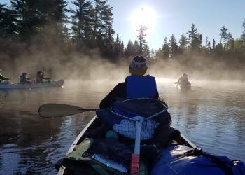
The Boundary Waters Canoe Area Wilderness extends nearly 150 miles along the International Boundary, adjacent to Canada’s Quetico and La Verendrye Provincial Parks, is bordered on the west by Voyageurs National Park, and by Grand Portage National Monument to the east. It is composed of lakes, islands, rocky outcrops and forest.
Prepare for Your Wilderness Trip
Before you reserve your permit, do your research! Visitors can find solitude, adventure, risk, and excitement but the trip planning begins months before entering the Wilderness.
Successful trips don't just happen. Plan ahead for the Boundary Waters Canoe Area Wilderness!
Make sure to thoroughly read the Boundary Waters Canoe Area Wilderness page and the Boundary Waters Canoe Area Wilderness Trip Planning Guide for tips on wilderness trip preparation.
Prior to reserving your permit, please also review the following:
- Boundary Waters Canoe Area Wilderness Regulations and Rules
- More About Boundary Waters Canoe Area Wilderness
When You're Ready
- Pick your activity
- Pick your Entry Point
- Pick your date(s)
- Reserve your permit
- Watch the Leave No Trace Videos 1 and 2
- Pack
- Pick up your permit and watch the 3rd Leave No Trace video with your group
Pro Tip: have several potential trips in mind in case permits are unavailable for your desired dates and entry point.

The Angleworm Lake Trail is a 12 mile hike that loops around Angleworm Lake. Most of this primitive trail is within the Boundary Waters Canoe Area Wilderness.
Baker Lake Rustic Campground is located in a stand of red pine on the shore of Baker Lake.
This location has a dispersed campsite accessible by foot from the boat launch area or boat along with a boat-in only campsite located on the north side of the lake (east o
A long ski trail which roughly parallels the Gunflint Trail road from near Mid-Trail to approximately the western end of Loon Lake.
Bearskin lake is 500 acres with 8 miles of shoreline. It borders Boundary Waters Canoe Area Wilderness on part of its north shoreline.
Big Lake offers an area for fishing, boating and camping. There is a boat ramp and 3 back country campsites on this lake.
This trail is 53 miles long and is a part of the Boundary Waters Canoe Area Wilderness. The trail follows the Canadian/Minnesota border.
Brule Lake trail is a 7 miles of trail that takes you into the Boundary Waters Canoe Area Wilderness.
Crane Lake is a large body of water and is a popular area for fishing and boating. There are 3 backcountry campsites located on the lake.
The Caribou Rock Trail is a 1.5 - 7 mile hike. The first 3/4 of a mile takes you to an overlook of West Bearskin lake.
Eagle Mountain Trail is a 3 1/2 mile hike to the top of Eagle Mountain, which at 2301 feet is the highest point in Minnesota.

Fall Lake Campground is located on the shores of Fall Lake and provides direct access into the Boundary Waters Canoe Area Wilderness.
Ham Lake is a 119-acre lake with 3.8 miles shoreline and a maximum depth of 40 feet.
The Herriman Lake Trail is 13 miles with loops. More than half of the trail is in the Boundary Waters Canoe Area Wilderness.
Homer Lake is a 433-acre lake with 12 miles of shoreline and a maximum depth of 22 feet. Access is by foot or boat, the boat access is on the east end of the lake.
Kawishiwi Lake is a lovely campground in a birch stand on the edge of the Boundary Waters Canoe Area Wilderness.
The Kekekabic Trail is a 46 mile trail with trailheads in the east and in the west (Kekekabic Trail West). The east trailhead is shared with the Centennial Trail.
The Kekekabic Trail is a 46 mile trail with trailheads on the east (Kekekabic Trail East) and west.
Lake Vermilion is 40,000 acres, 76 feet at its deepest point, and has 365 islands. It has the most shoreline of any lake in Minnesota and is known for its walle
This is a large system of summer hiking and winter XC ski trails (42 km).
Trails are maintained in the summer for day use hiking.
North Fowl lake is a large, 1,040 acre lake along the United States/Canadian border. This lake is shallow, with a maximum depth of only 10 feet.
The Norway Trail is 8 miles one way and passes through mature stands of red and white pine, over ledge rock and through some small wet areas.
Ojibway Lake offers a small picnic area, a back down ramp, and 2 island back country campsites.
Picket Lake is a remote, quiet 316 acre lake with 5.7 miles of shoreline. Launch at the beaver pond next to the parking lot.
Pine Lake, in Cook County, is a 98 acre lake with 3 miles of shoreline and a maximum depth of 34 feet.
The Powwow Trail was constructed in 1978-79 and is located in a remote part of the Boundary Waters Canoe Area Wilderness on the Superior National Forest.
Sawbill Lake Campground has immediate access to the Boundary Waters Canoe Area Wilderness, a beautiful, peaceful and wild natural feature of Minnesota's Superior National F
This large, 4,650 acre lake is also a entry point into the Boundary Waters Canoe Area Wilderness.
South Farm Lake Trail offers opportunities for intermediate level skiers.
From the Gunflint Trail visitors will hike from Rockwood Lodge, through the forest in between Birch and Moss Lakes.
Trout Lake is a deep, 258-acre lake a short drive from the Lake Superior shoreline. This is a busy lake, so expect company when visiting.