
Safety and Outdoor Ethics
There is some information that is vital to know before visiting a National Forest or Grassland. Check-in here first when planning your visit.
Know Now
Avoid Drone Use Near Bison
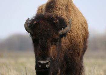
Bison are near-sighted and especially sensitive to noise above them or around them. Allow bison and cattle to graze in an area of peace and quiet on the prairie.
Cattle Help Maintain Grassland
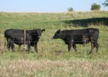
The Midewin National Tallgrass Prairie offers agricultural permits for grazing. Cattle's curiosity or maternal instincts may cause them to approach visitors. Please keep your distance from the cows & keep pasture gates closed.
Rules, Closures, and Forest Orders
As a visitor to the National Forest, you are asked to follow certain rules designed to protect the Forest, natural resources and to provide public safety for visitors.
Hunting Safety
- Check weather reports before your visit.
- Tell someone where you will be hunting and when you will return.
- Be familiar with the area.
- Dress properly and be prepared for the worst possible conditions.
- Check hunting equipment before and after each outing and maintain it properly. Familiarize yourself with its operation before using it in the field.
- Carry a spare set of dry clothing. Use layering techniques to prevent moisture while retaining body warmth. Always bring rain gear.
- Carry a first aid kit.
- Clearly identify your target before shooting.
- Put hunting plans in writing (dates, times, location and expected time of return).
- Be alert when hunting near developed areas and trails.
- Wear hunter orange or another highly visible color.
- Make yourself more visible: Wear colors that stand out, like red or orange, and avoid white, blacks, browns, earth-toned greens and animal-colored clothing.
- Don’t forget to protect “Fido”; for extra safety, consider bright colors for dogs.
- Make noise. Whistle, sing or carry on a conversation as you walk to alert hunters to your presence.
- Hunters should be listening for any sounds of animal movement.
- Be courteous. Once a hunter is aware of your presence, don’t make unnecessary noise to disturb wildlife. Avoid confrontations.
- Make yourself known. If you do hear shooting, raise your voice and let hunters know that you are in the vicinity.
- Know when hunting seasons are. Continue to hike, however learn about where and when hunting is taking place.
Seasonal Information
Summer Safety

Wear sunscreen and a hat.
It takes about 90 minutes, round-trip, to hike from the Iron Bridge Trailhead South to the viewing scopes where you might see bison. The trail is in direct sunlight. The trip in and back is too extensive for many short-legged dogs. Even with long-legged dogs, be sure to allow enough time for plenty of breaks. Bring plenty of water for both you and your dog.
Winter
Before you go: Check the weather forecast and road conditions, dress in warm, waterproof layer, and research the area and route. Pack the correct equipment and high-energy meals and snacks. Tell someone where you’re going and check in periodically.
Once you're there: Share the trail - avoid walking in ski tracks. Avoid dangerous or steep terrain. Pay attention to the changing weather conditions. Follow your map and know where you are at all times.
Visitor Maps and Trail Guides
East Side
Multi-Use
Named for the WWII-era portable bridge installed by volunteers here in 2007, this trail connects the southeast corner of the Twin Oaks Trail & the Forest Preserve District of Will County’s Wauponsee Glacial Trail. Klingler Cemetery connects the Wauponsee Glacial Trail to the Bailey Bridge & Turtle Pond. This active cemetery is owned by the Klingler-Love Cemetery Association and is registered with the state of Illinois. In the woods on the north side of the trail, between Klingler Cemetery & the gate to the east that leads to the Wauponsee Glacial Trail, you can see where the Klingler farmstead was located in the mid-1800s.

Multi-Use
This trail connects Henslow Trail & Twin Oaks Trail, looping through the Group 63 bunker field. Bunker 63-1 is open to experience inside.
Pedestrian Only
Rows of hedgeapple trees (also called Osage orange trees) connect Twin Oaks Trail to Group 63 Trail. The trail begins at the northwest corner of the Twin Oaks Trail, parallels Hoff Road and turns south to follow a former farm-to-market road lined with hedgeapple trees. Farmers planted Osage orange trees as cattle fences, & now they are where loggerhead shrikes have been spotted in early summer.
Located on the south side of the intersection of Hoff Road & Chicago Road near Elwood. Access to Bailey Bridge; Hedgeapple & Twin Oaks trails; Turtle Pond.

A great place to set out to look for bison. Wear sturdy, close-toed shoes & bring binoculars & water. The bison pasture is south, & the Group 63 bunker field is east. The trailhead provides access to all trails on the east side. The nearby “Iron Bridge,” which is a decommissioned railroad bridge, connects to the west side. Two historic farmstead sites (1840-1940) lie southeast of the parking area. Access to Group 63, Henslow & Route 53 trails.
Multi-Use
Meanders along State Route 53 (Illinois Route 66 Scenic Byway) & the bison pasture & connects to the Midewin Welcome Center. There is an overlook with benches & spotting scopes.

Pedestrian Only
Located along the south leg of Twin Oaks Trail, this trail starts alongside the Chicago Road seedbeds where upland prairie plant species grow. These native plants are a colorful spectacle through much of the summer & early fall. There is an “Acorn Prairie” planted by students in the Mighty Acorns program.
Multi-Use
Passes through remnants of the ammunition plant & rolling fields of hay, soybeans & wheat.
Located on Hoff Road near Gougar Road, the USDA FS manages this trailhead with the Forest Preserve District of Will County. Access to Bailey Bridge Trail, (Multi-Use); & Wauponsee Glacial Trail, (Multi-Use). Managed by the Forest Preserve District of Will County.
West Side
An outwash plain created by a geologic event during a massive flood that left the landscape mostly flat.
Pedestrian Only
Out-&-back trail starts at the River Road Trailhead, then goes north on Boathouse Road and exits the roadway to the west via old rail bed. The trail crosses Prairie Creek on a converted railroad trestle. The trail leaves the railbed & takes off across country to the north; then passes through where stone walls of the Lamping dairy barn can be seen just north of Prairie Creek. North of where the trail forks, up the left fork (going west) the Harlow Nicholson farmstead was located on the west side. This farmstead represents local farming from the mid-nineteenth century through 1940. The trail runs north & crosses Grant Creek. North of Grant Creek the trail branches into a loop that runs through the Blodgett Marsh area. Ducks, geese, blue-winged teal, black-necked stilts songbirds, great blue herons, egrets & various other wildlife have been seen and heard here. Nearby is very rare Dolomite Prairie where cactus grows.

Multi-Use
This trail connects Iron Bridge Trailhead & trails on the east side to River Road Trailhead on the west. Henslow Trail goes south from the trailhead through a wooded area where you can see where the Rodgers farm was located. From the Iron Bridge, the trail turns south & crosses through the Rockdale glacial moraine with views of the 811 bunker field & the Illinois River valley. The trail crosses Explosives Road & meanders southward. Just north of Explosives Road stands a 19-ton pre-historic glacial erratic. It was pushed by glacial activity possibly from as far away as Wisconsin. Henslow trail crosses Prairie Creek on a converted railroad trestle. You might see a kingfisher, great blue heron or great egret. Where the trail intersects with Boathouse Road, turn south to get to River Road trailhead & seedbeds. Cross the Iron Bridge traveling west & you will be on the first parcel of Midewin NTP land settled by Euro-Americans. Joseph Shoemaker farmed here since 1831. While there are no farm foundations, a house, barn & schoolhouse stood near the trail during the 1800s.

Pedestrian Only
Go through the fence on the north side of the parking lot & turn right onto Boathouse Road. A short distance north on the left, the trail begins on the west. Hike through the shade provided by an ancient savanna of oak trees which mostly pre-date European settlement. The trail continues through riparian forest. There are scenic overlooks, including at Buttonbush Pond, which is an oxbow lake. There are frogs, muskrats & red-winged blackbirds flitting from one cattail to another. Continue north through the woods to return to Boathouse Road. In the vicinity of the trail, archaeologists have identified Native American sites that are about 8,000 years old. At the north end of the trail, near where it rejoins Boathouse Road, stands a bur oak.

Used as a reference point by government land surveyors in 1821. On the east side of Boathouse Road is the South Patrol Road Restoration Area.
Picnic nestled amid royal catchfly, cardinal flower, wild bergamot, black-eyed Susans, compass plants & more in the largest of three seed reproduction gardens (seedbeds are also at Turtle Pond & Welcome Center).
North of River Road on Boathouse Road there are hundreds of native plants in thousands of acres. In fall, the area is full of purple asters & goldenrod. Access to Blodgett Marsh, Henslow & Prairie Creek Woods trails.

This area has wet prairie, marsh & sedge meadow & mesic prairie communities. It is the most mature prairie restoration area at Midewin NTP. There are hundreds of different species of prairie plants, including grasses, forbs & sedges. There might be purple spiderwort & white foxglove beardtongue; and wetland plants such as cardinal flower, blue flag iris, swamp milkweed & a variety of sedges & rushes. In fall there is goldenrod, bottle gentian & asters. In winter, people have seen long-eared owls, red-tailed hawks & other raptors.