
Visitor Maps and Guides
We have a variety of maps and visitor guides to help you plan your next adventure!
Wilderness & Forest Visitor Maps
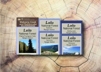
The Lolo National Forest is covered by five ranger district maps, and a map of the Welcome Creek and Rattlesnake Wildernesses, as well as the Bob Marshall Wilderness Complex and Selway-Bitterroot Wilderness Maps.
Buy online: USGS Map Store (Hardcopy maps) | Avenza Maps for Mobile (Digital maps)
Travel Management Maps
The Lolo National Forest has free travel management maps, called "motor vehicle use maps" (MVUMs), and Over Snow Vehicle Use Maps. These maps show legal designations of where you can travel with various motorized vehicles. Paper copies are available at our offices, or you can download GeoPDFs for use on your mobile devices at Avenza Maps.
Forest Service Digital Maps

Forest Service Digital Maps cover all lands administered by the Forest Service. They are available in a variety of scales. Maps are free as a digital download.
Download Off-line Maps [ArcGIS Online interactive tool]
Get the Avenza Maps App for Mobile
Many of our maps are available for a cost or free on the Avenza Map Store. With the app you can use the satellite capabilities of your mobile device and navigate on a compatible map even without cell service.
- iOS App at the Apple App Store
- Android App at the Google Play store