
Additional Tools and Information
These additional references and links may be useful in helping managers decide the best mitigation method for a particular situation.
"Felling Hazard Trees with Explosives" (0867–2325–MTDC) describes the use of explosives to fell trees that are too dangerous for sawyers to fell. This tech tip is available at http://www.fs.fed.us/t-d/php/library_card.php?p_num=0867%202325.
Forest Service logging engineers often refer to the handbook "Harvesting Systems and Equipment in British Columbia" to determine the best equipment for a job. This handbook is available at http://www.for.gov.bc.ca/hfd/pubs/docs/sil/sil468.htm. Contact your local logging systems specialist or timber and fuels management staff to determine the equipment that best fits your danger tree situation.
The Intermountain Region Chain Saw and Crosscut Program Web site provides a variety of hazard tree resources at http://fsweb.boise-nf.r4.fs.fed.us/safety/hazard%20trees.shtml.
Using a Recreation Facility Analysis for Danger Tree Mitigation
A forest's recreation facility analysis (RFA) provides land managers with helpful information to prioritize danger tree mitigation in recreation areas. An RFA defines the proposed actions for management of forest recreation sites in order to meet the desired future condition that aligns with the forest plan.
Written on a 5-year cycle, an RFA can be adapted annually to changes in available resources and funding. Detailed information about an RFA is available at http://www.fs.fed.us/recreation/programs/rfa/.
Using Geographical Information System Data for Planning Danger Tree Mitigation
Geographical information system (GIS) data can be used by resource managers to build an initial reconnaissance map of high-priority areas for locating danger trees and selecting appropriate mitigation methods (figure 19). The slope and road layers can help determine the types of tools, machines, or methods that are practical for danger tree mitigation. The same scale should be used for all maps and overlays requested. If no particular scale is available, start with the U.S. Geological Survey (USGS) 1:24,000 scale map.
Map layers should include the following:
- A recent orthophoto or satellite base layer
- Location—a township/range/section overlay.
- Slope—a 40-foot contour overlay.
- Machine capabilities—a slope grouping overlay with clear representing 0- to 40-percent slopes, yellow representing 41- to 55-percent slopes, orange representing 55- to 70-percent slopes, and red representing slopes steeper than 70 percent.
- Location—a township/range/section overlay.
- An improvements overlay based on the motor vehicle use map, and including closed roads, motorized trails, nonmotorized trails, closed trails, recreation facilities, powerlines, gas lines, water lines, sewer lines, and radio or communication sites.
- A decadent stands overlay, including old-growth stands (brightly colored for emphasis).
- A potential problem vegetation overlay compiled to show the past 15 years of damage caused by insects, disease, wind, snow, and fire (brightly colored for emphasis). Combining overlays 3 and 4 also is an option.
- A Forest Service property boundary map overlay.
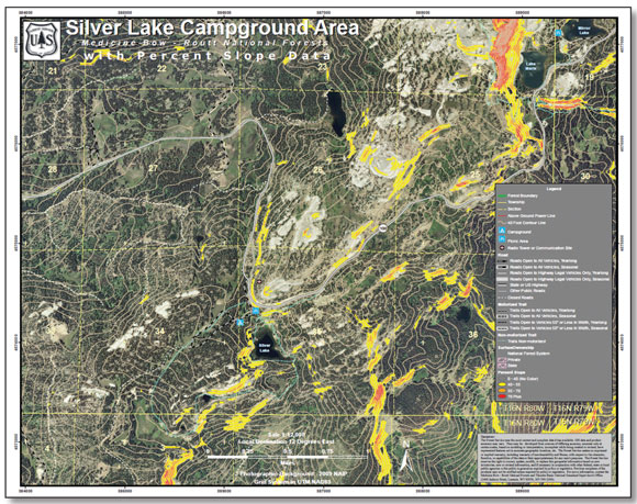
Figure 19—A GIS reconnaissance map used to identify high-priority areas for danger tree mitigation.
Courtesy of the U.S.Department of the Interior