  Privacy
| Legal Privacy
| Legal |
Table of Contents Back | Next | Home | Cover Page |
Technology & Development Center |
Investigative Methods for Controlling Groundwater Flow to Underground Mine Workings
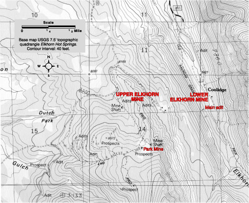 |
| Figure 1The Elkhorn Mine is in the Elkhorn Creek drainage south of Wise River, MT. The surrounding area is generally small, swampy valleys separated by steep valley walls. |
Two sites in southwestern Montana were selected for investigation using basic information and personnel whose expertise is commonly available to most national forest ranger districts. The three areas of investigation for the case studies were hydrology and hydrogeology, soil and vegetation, and geology. The sites were chosen because both had existing water quality data, they differed in their geologic setting, and they represented a range in the size of the mine and the quantity of adit discharge. The emphasis in both case studies was to use existing information and moderate-level field reconnaissance to understand the nature and extent of the adit-discharge problem. The objective of the studies was to apply basic information and evaluate the potential for source controls to reduce the adit discharge.
The Elkhorn mining district is on patented and unpatented mining claims and on land administered by the Beaverhead-Deer-lodge National Forest in T. 4 S., R. 12 W., sec. 14 (tracts AADD), and sec. 11 (tracts DDDB) near the ghost town of Coolidge, MT (figure 1). The lower (or 1,000-foot-level) adit discharges a bright-orange, iron-stained discharge that flows into Elkhorn Creek. An upper camp (or 300-foot level) at Elkhorn has a small discharge that infiltrates into the ground. This upper camp is located on the former Idanha unpatented mining claim and is referred to as the Idanha tunnel. It produced much of the ore processed at the mill. The Park Mine lies on the same side of the drainage divide as the Elkhorn Mine and may be hydraulically connected to the Elkhorn workings.
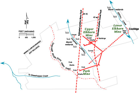 |
| Figure 2—The Elkhorn Mine is one of several mines in the area. The lower Elkhorn workings extend toward the upper Elkhorn Mine and the Park Mine. The map shown is a composite sketch based on unpublished maps in the Montana Bureau of Mines and Geology mineral property files. |
The mining district was first worked from 1872 to 1874. The first 50 feet of shaft produced 15 tons of high-grade ore that contained 500 to 800 ounces of silver per ton and 15-percent copper. Many of the early workings were prospects, shallow shafts, and short adits. After a period of inactivity from 1893 to 1906, the mine was operated by the Boston-Montana Development Co., which consolidated the claims, built a narrow-gauge railway, extended the high-tension electric line to the mine, built a 750-ton-per-day mill, and significantly developed the underground workings that included the upper and lower adit. Production from the Elkhorn mining district was estimated at 851,725 pounds of lead, 4,100 pounds of zinc, 370,799 pounds of copper, 180,843 ounces of silver, and 1,013 ounces of gold.
Ruppel and others (1993) reported that the ore is hosted in Late Cretaceous or Tertiary granitic rocks associated with the Pioneer Batholith. One set of veins strikes N. 50° E. and dips 65° to 85° SE. The other minor set of veins strikes generally east-west and dips steeply to the north (Evans 1946). Vein minerals included quartz, pyrite, tetrahedrite, galena, sphalerite, chalcopyrite, and molybdenite.
The two main veins, the Park and Idanha, are coincident with a general north-south trend of mineralized faults in the area. Two large faults, the Mono and Comet, were mapped along with the workings (figure 2). Both the upper Elkhorn and Park Mines are within the graben (depression between two parallel faults) formed by the faults. Drifts branching off the main tunnel of the lower Elkhorn breached the Comet fault at least twice. The Comet fault trends north-south along the eastern border of the mineralized zone. It passes near the portal of the 300-foot level and dips 45° NW. The Mono fault is 1,200 feet east of the Comet fault. The Mono fault dips east 45° and makes a sort of trough or graben with the Comet fault. There is minor movement or displacement on the Mono fault. In addition to the two major faults, several other faults are described in the geology of the mines. There is a 300-foot-wide zone of fracturing. According to Evans (1946), the geology of the rock is simple (granitic or quartz monzonite), but the area is structurally complex. The mineralized zone was reported to be 3,000 feet wide by 7,000 feet long. Throughout this zone is a network of “compact interrelated system of fissures” (Evans 1946). These fissures may be a source of water.