
Official websites use .gov
A .gov
website belongs to an official government organization in the
United States.
Secure .gov websites use HTTPS
A lock
(
) or https:// means you've safely
connected to the .gov website. Share sensitive information only
on official, secure websites.


Recreation
So Much To Do & See
Current recreation fees and schedule
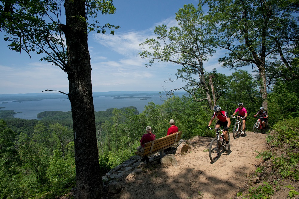
The Ouachita National Forest is located primarily in the Ouachita Mountains of Arkansas and Oklahoma. Outstanding mountain views coupled with picturesque streams, rivers, and lakes provide a unique and highly valued setting for outdoor recreation. The forest offers high quality nature related-sightseeing, scenic driving, hunting, fishing, and dispersed camping. Learn about the areas rich history at wayside exhibits along a scenic drive or experience unique botanical, mineral, and prehistoric resources featured in information and educational programs. An extensive trail system provides for all types of uses including hiking, mountain biking, horseback riding, and off-highway vehicles (OHV) riding. A variety of services can be found at developed campgrounds ranging from rustic tent pads to full-service RV hookups. Enjoy exceptional water-based recreation opportunities including fishing, non-motorized boating, and passive enjoyment of streams, rivers and lakes.
Dispersed Camping in the Forest:
Many people enjoy the solitude and primitive experience of camping away from developed campgrounds and other campers. Dispersed camping is the term used for camping anywhere in the National Forest OUTSIDE of a designated campground. Dispersed camping means no services; such as trash removal, and little or no facilities; such as tables and fire pits, are provided. There are extra responsibilities and skills that are necessary for dispersed camping. It is your responsibility to know these before you try this new experience. Be sure to read the guidelines before heading out.
Visitors are primarily responsible for their own safety. Keep in mind, trails and roads may be open for use, but please recreate responsibly and follow public health guidelines regarding social distancing while you recreate in National Forests. Law enforcement and search and rescue operations may be limited due to COVID-19 issues. High risk activities such as rock climbing or motorized activities that increase your chance of injury or distress should be avoided. For the most current and accurate information about COVID-19, contact your local health officials or visit the CDC website at www.cdc.gov. Information from the U.S. Department of Agriculture is available at: www.usda.gov/coronavirus.
Current Recreation Conditions
| Area Name | Status | Area Conditions |
|---|---|---|
| Albert Pike Day Use | Open | Day use/swimming only. Pavillion remains open. |
| Bard Springs Recreation Area | Temporarily Closed | Campground closed due to storm damage. Day-use area open, including restroom. Walk-in only. |
| Bear Creek Trail & Horse Camp | Open | Campground is open. Restrooms are also open. |
| Bear Mountain Shooting Range | Open | Closed on Mondays 6:00 - 9:00 am for grounds maintenance. No restrooms. |
| Big Brushy Creek Day Use | Open | Day Use Only. Restroom open. |
| Billy Creek Recreation Area | Open | No drinking water available. No trash services- pack it in, pack it out. |
| Camp Clearfork | Open | Residential group-use camp available for general public use, family reunions, civic and church groups, scouts, universities, and other large meetings. Open May to November seasonally. |
| Cedar Lake Recreation Area | Open | Open year round, except North Shores day use and picnic shelters which are open seasonally April- November. |
| Charlton Recreation Area | Open | New swim deck construction completed, and swim area is open! Loop A bathhouse is closed due to storm damage, but camping is still available in Loop A. Loops B and C open for use. |
| Collier Springs Day Use | Open | Open all year - Picnic/Day Use Only |
| Crystal Campground | Open | No water or electric available. Restroom is open. |
| Dragover Day Use | Open | Day use only. River access. Restroom closed. |
| Dutch Creek CCC Day Use | Open | CCC Camp. Day-use only. |
| Fourche Mountain Recreation Area | Open | Open all year. Restroom closed. |
| Fulton Branch Day Use | Open | Open all year. Day-use only. No charge. |
| Horsethief Springs Day Use | Open | Open |
| Iron Springs Day Use | Open | Open all year. Day-use only. Restroom open. |
| Jack Creek Recreation Area | Open | Open |
| Kerr Memorial Arboretum | Open | The trails and parking area are open - however, the restrooms are closed and no water available. The closest restroom is at the Winding Stair Campground. |
| Knoppers Ford Day Use | Open | Day-use only. |
| Lake Sylvia Recreation Area | None | Lake Sylvia and Camp Ouachita are managed by Arkansas State Parks. |
| Little Missouri Falls Trailhead | Open | Open all year. Day-use only. Restrooms open. |
| Little Pines Recreation Area | Open | Open. No reservations. Boat ramp open all year. |
| Old Military Road Day Use | Open | Open - restrooms closed |
| Peeler Gap Shooting Range | Open | No restroom available |
| Pigeon Roost Shooting Range | Open | No restrooms. open sunup to sundown. For more information contact the Caddo-Womble Ranger District at 870 867-2101. |
| Pipe Springs Day Use | Open | Restrooms closed |
| Red Slough Wildlife Management Area | Open | |
| Reed Mountain Shooting Range | Open | No restrooms |
| River Bluff Day Use | Open | Open all year. Day-use only. |
| Rocky Shoals Day Use | Open | River access. Day-use only. Restroom open. |
| Shady Lake | Open | Open. Campsites first-come/first-served only. |
| Shirley Creek Day Use | Open | River access. Day Use only. |
| South Fourche Recreation Area | Open | Open all year. No water/electric available. Restrooms are open. |
| Talimena National Scenic Byway | Open | The scenic byway is open year-round. The East End Visitor Information Center is closed. Restrooms are open. For information, contact the Mena office at 479-394-2382 |
| Winding Stair Campground | Open | Open. |
| Wolf Pen Gap | Open | **The trail system will close during periods of heavy rain.** |
Spotlights
Charlton Recreation Area
Charlton Recreation Area is located 20 miles west of Hot Springs along Highway 270.
Picnic, swim, hike, and fish along picturesque Walnut Creek, a cold, spring-fed mountain stream in the heart of the Ouachita National Forest. This historic recreation area features a captivating native stone dam that forms the swimming area and rustic bathhouse built by the Civilian Conservation Corps federal work program in 1935.
Overview:
The campground is made up of three loops with 46 campsites, ranging in amenities of no services to campsites with electric, water and sewer provided. Bathhouse with warm showers and flush toilets are provided. Day use hosts spring fed swimming site with some of the area's coldest water found in the area, even during the hottest of summer temperatures. A 1-mile nature trail can be found near the campground and connections to the 40-mile Lake Ouachita Vista Trail lead from the campground as well. Charlton Campground is located 20 miles west of Hot Springs National Park, Arkansas.
Information about Charlton Recreation Area.
Information about Charlton Recreation Area - Spanish
Other recreation sites within the Caddo/Womble Ranger District
Shady Lake
Scenic 25-acre lake in remote mountain setting.The Civilian Conservation Corps developed the Shady Lake Recreation Area in 1937. The Shady Lake Trail traverses Saline Creek, passes the historic Shady Lake Dam, and continues along the eastern edge of the campground. The trail is ideal for day hiking. Mountain bikers may also use the trail.
Overview:
The campground is made up of four camping loops, with 66 campsites, ranging in amenities of no services to campsites with electric and water services provided. Bathhouses with warm showers and flush toilets. Day use hosts a swimming site, picnic pavilions, restrooms, picnic tables with BBQ grills and a 3-mile hiking trail that follows the shoreline of Shady Lake. Campsites can accommodate RV's up to 32-feet in length. Shady Lake is located approximately 40-miles west of Glenwood, Arkansas.


