
Official websites use .gov
A .gov
website belongs to an official government organization in the
United States.
Secure .gov websites use HTTPS
A lock
(
) or https:// means you've safely
connected to the .gov website. Share sensitive information only
on official, secure websites.


Recreation
Current Recreation Conditions
| Area Name | Status | Area Conditions |
|---|---|---|
| Allen Springs Campground | Open | |
| Allingham Campground | Open | |
| Arlies Rock/North Gateway Information Viewpoint | Open | |
| Aspen Day Use Area | Open | |
| Beach Picnic Area | Open | |
| Bear Valley Trailhead | None | |
| Benham Falls East Day Use / Trailhead | Open | |
| Benham Falls West Day Use / Trailhead | Open | |
| Bessie Butte Trail | None | |
| Besson Picnic Area | Open | |
| Big Cove Boat-In Campground | Open | |
| Big Eddy Trailhead | Open | |
| Big River Boating Site | Open | |
| Big River Campground/Big River Group | Open | |
| Black Butte Trailhead | None | |
| Black Crater Trailhead | None | |
| Blue Bay Boating Site | None | |
| Blue Bay Campground | Open | |
| Boundary Springs Campground | Open | |
| Broken Top Trail | None | |
| Broken Top Trailhead | None | |
| Bull Bend Boating Site | None | |
| Bull Bend Campground | Open | |
| Buttes Loop Trailhead | None | |
| Camp II OHV Staging Area | None | |
| Camp Sherman Campground | Open | |
| Candle Creek Campground | Open | |
| Chief Paulina Horse Camp | Open | |
| China Hat Campground | None | |
| Cinder Hill Campground | Open | |
| Cold Springs Campground | Open | |
| Contorta Flat Campground | Open | |
| Contorta Point Group Campground | Open | |
| Corral Swamp Trailhead | None | |
| Cow Meadow Campground | Open | |
| Crane Prairie Boating Site | None | |
| Crane Prairie Campground | Open | |
| Crater Butte Trailhead | None | |
| Crater Ditch Trailhead | None | |
| Crescent Creek Campground | Open | |
| Crescent Lake Boat Launch | None | |
| Crescent Lake Campground | Open | |
| Crescent Lake Guard Station | Open | |
| Crescent Lake Sno-Park | Open | |
| Crescent Lake Yurts | Open | |
| Crescent Ranger District Office | None | |
| Cultus Corral Horse Camp | Open | |
| Cultus Lake Boating Site | Open | |
| Cultus Lake Campground | Open | |
| Cultus Lake Day Use Area | Open | |
| Deer Lake Trailhead | None | |
| Devils Lake Campground | Closed | |
| Devils Lake/South Sister Trailhead | None | |
| Dillon Falls Day Use Area | Open | |
| Driftwood Campground | Open | |
| Dutchman Sno-Park/Trailhead | Open | |
| East Davis Lake Campground | Open | |
| East Fort Rock OHV Trail System | None | |
| East Lake Campground | Open | 2024 Season - Caampground opening is delayed to June 21, to complete in-depth hazard tree removal and clean-up started last fall. |
| Edison Butte OHV Trail System | None | |
| Edison Butte Sno-Park/Staging Area/Trailhead | Open | 2023-2024 Winter Season: Deschutes National Forest recreation staff assessed the condition of the Edison Snow Shelter near Edison SnoPark and determined that the integrity of the structure has declined to the point it needs to be closed for public safety this winter. The Edison Shelter is located thirteen miles west of Bend and approximately one mile from the Edison SnoPark along the Tesla Snowshoe Trail and Lightbulb Loop Nordic Ski Trail. Open snow shelters in the area include AC/DC, Kwolh and Sheridan Shelters. For questions, contact the Bend-Fort Rock Ranger District at (541) 383-5300. |
| Elk Lake Boating Site | Open | |
| Elk Lake Campground | Open | |
| Elk Lake Guard Station | None | |
| Elk Lake Trailhead | None | |
| Fall River Campground | Open | |
| Fall River Guard Station | Open | Reservation Only |
| Fall River Trailhead | None | |
| Gorge Campground | Open | |
| Graham Corral Horse Camp | Open | 2024 - We have experienced a loss of water at this site. The Forest Service continues to explore alternative solutions for delivering water, but please plan to provide water for your stock animals. |
| Green Lakes/Soda Creek Trailhead | None | |
| Gull Point Boating Site | None | |
| Gull Point Campground | Open | |
| Horse Butte Trailhead | None | |
| Hosmer Lake Boating Site | Open | |
| Indian Ford Campground | Open | |
| Irish-Taylor Trailhead | None | Please use caution when recreating in areas that were impacted by the 2022 Cedar Creek Fire. A burned landscape presents a number of safety hazards that either did not exist prior to the fire or have been exacerbated by the effects of the fire. In some cases, these hazardous conditions may persist for several years after a fire. Be very aware of your surroundings, follow warning signs, area closures and directions from agency personnel, and pay particular attention to these potential safety hazards. Be especially wary of hazard trees after rain events or during wind.
When recreating in a burned area:
|
| Jack Creek Campground | Open | |
| Jefferson Lake Trail | None | |
| Jefferson Lake Trailhead | None | |
| Junction Sno-Park | Open | |
| Kapka Sno-Park | None | |
| Lava Butte Interpretive Site | Open | Pedestrian and bike access is available year round. E-bikes permitted on road up Lava Butte. |
| Lava Camp Lake Campground | Closed | |
| Lava Cast Forest Day Use Interpretive Site | Open | |
| Lava Island Day Use Area | Open | |
| Lava Lake Boating Site | Open | |
| Lava Lake Campground | Open | |
| Lava Lands Visitor Center | Open | |
| Lava River Cave Interpretive Site | Open | |
| Lemish Lake Trailhead | None | Please use caution when recreating in areas that were impacted by the 2022 Cedar Creek Fire. A burned landscape presents a number of safety hazards that either did not exist prior to the fire or have been exacerbated by the effects of the fire. In some cases, these hazardous conditions may persist for several years after a fire. Be very aware of your surroundings, follow warning signs, area closures and directions from agency personnel, and pay particular attention to these potential safety hazards. Be especially wary of hazard trees after rain events or during wind.
When recreating in a burned area:
|
| Link Creek Campground | Open | |
| Little Cove Boat-In Campground | Open | |
| Little Crater Boating Site | None | |
| Little Crater Campground | Open | 2024 Season - Caampground opening is delayed to June 21, to complete in-depth hazard tree removal and clean-up started last fall. |
| Little Crater Day Use Site | None | |
| Little Cultus Boating Site | None | |
| Little Cultus Campground | Open | |
| Little Cultus Lake | None | |
| Little Fawn Boating Site | Open | |
| Little Fawn Campground | Open | |
| Little Lava Lake Boating Site | Open | |
| Little Lava Lake Campground | Open | |
| Lower Bridge Campground | Open | |
| Lower Canyon Creek Campground | Open | |
| Lucky Lake Trailhead | Open | |
| Mallard Marsh Campground | Open | |
| Many Lakes Trailhead | None | Please use caution when recreating in areas that were impacted by the 2022 Cedar Creek Fire. A burned landscape presents a number of safety hazards that either did not exist prior to the fire or have been exacerbated by the effects of the fire. In some cases, these hazardous conditions may persist for several years after a fire. Be very aware of your surroundings, follow warning signs, area closures and directions from agency personnel, and pay particular attention to these potential safety hazards. Be especially wary of hazard trees after rain events or during wind.
When recreating in a burned area:
|
| McKay Crossing Campground | Temporarily Closed | June 25, 2024: McKay Crossing Campground has been evacuated & closed due to the Darlene 3 Fire. |
| Meadow Day Use Area | Open | |
| Meek Lake Trail | None | |
| Meissner Sno-Park/Trailhead | Open | |
| Minto Lake Trail | Unreachable | BEWARE! Since 2003, Brush Creek, Minto Lake, Sugar Pine Ridge Trail and northern sections of Summit Trail have been in a "no current maintenance" condition. With heavy blowdown, dense brush, lack of identifiable trail surface and erosion due to B & B Fire damage, these trails are considered impassable and are not recommended. |
| Monty Campground | Open | |
| Newberry Group Campground | Open | |
| North Davis Boating Site | Closed | CLOSED: This boat ramp is closed for the 2024 season due to significant hazard tree mitigation needs. The Forest Service has identified trees showing signs of future failure. In order to provide for public safety, this facility will remain closed until the hazards have been mitigated. |
| North Davis Creek Campground | Closed | CLOSED: This campground is closed for the 2024 season due to significant hazard tree mitigation needs. The Forest Service has identified trees showing signs of future failure. In order to provide for public safety, this facility will remain closed until the hazards have been mitigated. |
| North Twin Boating Site | None | |
| North Twin Lake Campground | Open | |
| North Wickiup Boating Site | Open | |
| Odd Fellows Cabins | Closed | |
| Odell Lake | None | |
| Ogden Group Campground | Temporarily Closed | June 25, 2024: Ogden Group Camp has been evacuated & closed due to the Darlene 3 Fire. ATTENTION: The water system at this location has failed and there will be no water service at this site for the 2024 season. We apologize for the inconvenience. |
| Osprey Point Trailhead | Open | |
| Pacific Crest National Scenic Trail - Cowhorn | None | |
| Pacific Crest National Scenic Trail - Diamond Peak | None | |
| Pacific Crest National Scenic Trail - Three Sister | None | |
| Paulina Falls Day Use Area | None | |
| Paulina Falls Trail | None | |
| Paulina Lake Boating Site | Open | |
| Paulina Lake Campground | Open | |
| Paulina Lake Day Use Area | Open | |
| Paulina Peak Trailhead | None | |
| Perry South Campground | Open | |
| Peter Skene Ogden Trailhead | None | |
| Phil's Trailhead | Open | Current Trail Closures (July 2023) We are restoring the forest adjacent to the City of Bend to improve forest health, create a diversity of plant and wildlife habitat and to protect our communities and quality of life. Historically in Central Oregon small wildfires or insect infestations occurred creating a forested of different aged trees, underbrush, and openings, which allowed a diversity of wildlife and plants to flourish and kept forests resilient to large scale disturbances. The goal of these projects is to restore a more resilent and healthy forest. |
| Pine Mountain Campground | None | |
| Pine Rest Campground | Open | |
| Pioneer Ford Campground | Open | |
| Point Campground | Open | |
| Prairie Campground | Temporarily Closed | June 25, 2024: Prairie Campground has been evacuated & closed due to the Darlene 3 Fire. ATTENTION: The water system at this location has failed and there will be no water service at this site for the 2024 season. We apologize for the inconvenience. |
| Princess Creek Boat Launch | None | |
| Princess Creek Campground | Open | |
| Pringle Falls Campground | Open | |
| Quinn Meadow Horse Camp | Open | |
| Quinn River Boating Site | Open | |
| Quinn River Campground | Open | |
| Ray Atkeson Trailhead | None | |
| Reservoir Campground | Closed | CLOSED: This campground is closed for the 2024 season due to significant hazard tree mitigation needs. The Forest Service has identified trees showing signs of future failure. In order to provide for public safety, this facility will remain closed until the hazards have been mitigated. |
| Rim Butte OHV Trail System | None | |
| Riverside Campground | Open | |
| Road 25 OHV Staging Area | None | |
| Road 2510 OHV Staging Area | None | |
| Rock Creek Boating Site | Open | |
| Rock Creek Campground | Open | |
| Rosary Lakes Trailhead | None | |
| Scout Lake Campground | Open | |
| Scout Lake Day Use Area | Open | |
| Senoj Lake Trail #14.1 | None | |
| Sheep Bridge Boating Site | Open | |
| Sheep Bridge Campground | Open | |
| Sheep Springs Horse Camp | Open | |
| Simax Beach Picnic Area | None | |
| Simax Group Campground | Open | |
| Sisters Cow Camp Horse Camp | None | |
| Sisters Mirror Trailhead | None | |
| Six Lakes Trailhead | Open | |
| Skyliners Sno-Park/Trailhead | Open | |
| Slough Day Use Area | Open | |
| Smiling River Campground | Open | |
| Soda Creek Campground | Open | |
| South Campground | Open | |
| South Lava OHV Staging Area | None | |
| South Shore Campground | Open | |
| South Twin Day Use Area | Open | |
| South Twin Lake Campground | Open | |
| Sparks Lake Boating Site | Open | |
| Sparks Lake Day Use Area | Open | |
| Sparks Lake Trailhead | None | |
| Spring Boat Launch | Closed | |
| Spring Campground | Open | |
| Sun-Lava Paved Path | None | |
| Sunset Cove Boat Launch | Open | |
| Sunset Cove Campground | Open | |
| Sunset View Day Use Area | Open | |
| Swamp Wells Horse Camp | None | |
| Swampy Lakes Sno-Park/Trailhead | Open | |
| Tam McArthur Rim Trailhead | Closed | |
| Tam McArthur Trail | Closed | |
| Tandy Bay Picnic Area | None | |
| Tenino Boating Site | Open | |
| Tetherow Boat Launch | Open | |
| Three Creek Lake Campground | Open | |
| Three Creek Meadow Horse Camp | Open | |
| Todd Creek Horse Camp | Closed | |
| Todd Creek Trailhead | None | |
| Todd Lake Campground | None | Wilderness permits are not required to access/use Todd Lake. However, recreators who use the nearby Todd Lake Trail are required to acquire a Central Cascades Wilderness Permit in advance for both day use and for overnight use. See "Permit Info" below for more details. |
| Todd Lake Day Use Area/Trailhead | Closed | Wilderness permits are not required to access/use Todd Lake. However, permits are required to hike the nearby Todd Lake Trail #34 or if entering the Three Sisters Wilderness. |
| Trapper Creek Boat Launch | Open | |
| Trapper Creek Campground | Open | |
| Tumalo Falls Day Use Area | Open | November 13, 2023 - Forest Service Road 4603 is closed for the season to motor vehicles. The road can still be used for non-motorized access to Tumalo Falls. The round-trip mileage from the gate to Tumalo Falls is approximately five miles. |
| Vista Butte Sno-Park | Open | |
| Wake Butte Trailhead | None | |
| Wanoga Snow Play Area Sno-Park | Open | |
| West Cultus Boat-In Campground | Open | |
| West South Twin Boating Site | Open | |
| West South Twin Campground | Open | |
| Whispering Pine Horse Camp | Open | |
| Whitefish Horse Camp | Open | |
| Whychus Creek Scenic Overlook Trailhead | Open | The top rail of the Whychus Creek Overlook wall will be removed, and two viewing portals with security cables will be created to improve accessibility. The modifications will provide better views of the creek and mountains for visitors with disabilities. The modification project will begin May 6 and is expected to conclude May 9. Further construction may continue past May 9, but trail and area closures aren’t anticipated. The Whychus Creek Overlook will be closed for public safety on May 6. The Whychus Creek Overlook and south side of the Whychus Creek Overlook Trail (#4069) will be closed from May 7 – 9 while work is ongoing. The north side of the Whychus Creek Overlook Trail (#4069), Whychus Draw Trail (#4071), and access to Whychus Creek will remain open May 7 – 9. Trail closure signs will be posted at the trailhead and along the trail to identify the closures. |
| Wickiup Plains Trailhead | None | |
| Windy Group Campground | Open | |
| Winopee Trailhead | Open | |
| Wyeth Boating Site | None | |
| Wyeth Campground | Open |
Spotlights
Newberry National Volcanic Monument - Deschutes NF
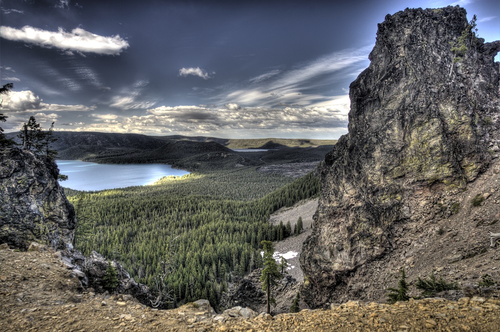 In November of 1990, Newberry National Volcanic Monument was created within the boundaries of Deschutes National Forest. Managed by the U.S. Forest Service, this monument provides a unique opportunity to view the Lava Lands of central Oregon. Newberry National Volcanic National Monument includes 54,000+ acres of lakes, lava flows, and spectacular geologic features in central Oregon. The highest point within the Monument is the summit Paulina Peak (7,985 ft.), showcasing views of the Cascades, Newberry Caldera and across the High Desert.
 Although commonly referred to as Newberry Crater, the "crater" is in fact a caldera formed when the overlying rocks collapse when a magma chamber is emptied. The caldera stretches across 17 square miles in the heart of the volcano. The 1,200 square mile volcano (about the size of Rhode Island) remains very active to this day. Newberry is both seismically and geothermally active. Geologists believe the caldera sits over a shallow magma body only 2 to 5 kilometers deep. Visitors see numerous cinder cones and vents (over 400 throughout the area), miles of basalt flows, as well as rhyolite flows of obsidian.
- For up-to-date facts on Newberry Volcano, click here.
- Read the latest version of Volcanic Vistas.
- Enjoy this video highlighting the accessibility of Lava Lands Visitor Center!
Cascade Lakes Welcome Station
Located just past mile post seven on the Cascade Lakes Scenic Byway, the Cascade Lakes Welcome Station serves as a gateway to some of the most popular trails, lakes and recreation areas on the Deschutes National Forest. The Welcome Station also offers parking and access to Phil’s and Wanoga mountain biking trails systems.
The Cascade Lakes Welcome Station provides visitors an opportunity to buy recreation passes, local maps, guidebooks and other educational materials. In addition to offering one-day recreation passes and the annual Northwest Forest Pass (good for all National Forests in Oregon and Washington), the Welcome Station also offers a number of interagency pass options.
Staffed with both Forest Service rangers and employees from Discover Your Forest, the Deschutes National Forest’s non-profit partner, the Welcome Station gives visitors the opportunity to ask questions, while learning about trail conditions, recreation opportunities and the unique Central Oregon landscape.

