
Official websites use .gov
A .gov
website belongs to an official government organization in the
United States.
Secure .gov websites use HTTPS
A lock
(
) or https:// means you've safely
connected to the .gov website. Share sensitive information only
on official, secure websites.


Waldo Lake Area
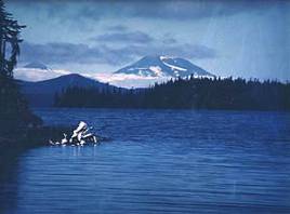
Thick forests, hiking, mountain biking, camping, swimming and boating. Waldo Lake is a recreation gem of the Cascades (besides the hordes of mosquitoes in early summer). Waldo Lake is one of the largest natural lakes in Oregon. Lying high on the western slopes of the Oregon Cascades, Waldo Lake is one of the largest natural lakes in Oregon and one of the purest lakes in the world. It has no permanent inlet to bring nutrients into the lake for plant growth. The lack of plant life contributes to its purity. You can see to depths of 120 feet on a calm day. It offers a uniquely peaceful setting on the water and along remote shorelines, surrounded by forests of Douglas fir and Western Hemlock. Recreation in the area is abundant with the lake an ideal location for water activities like sailing, canoeing and swimming. See more photos.
CAMPING
Waldo Lake’s three developed campgrounds usually open in late June or early July, depending on snowpack. North Waldo, Islet, and Shadow Bay have over 200 developed sites with toilets, potable water and boat ramps at Waldo Lake. Many campsites can be reserved up to six months in advance of arrival through recreation.gov. Campgrounds are often full mid-August into September.
Waldo also has nearly 50 primitive dispersed campsites around the lake. Dispersed campsites are free, but there are rules for staying in a dispersed site, including how to dispose properly of waste (there are no restroom facilities at these sites).
BOATING
Waldo Lake is one of the clearest lakes in Oregon and to help maintain the purity, only electric boats motors traveling less than 10 mph. Non motorized boats such as canoes, kayaks and paddle boards are popular along with the occasional sailboat. Boaters may debark at Waldo’s two islands for a picnic or scampering around, but may not camp there overnight.
Boating Regulations & Boating Safety: Oregon State Marine Board manages boating regulations. Visit their website for boating regulations and safety information. They also have links to information about water levels.
HIKING/BIKING
Waldo Lake borders the Waldo Lake Wilderness area. There are numerous trails that lead to nearby wilderness lakes.
Mountain bikers may use any trail marked for the sport. The 20-mile Waldo Lake Trail (also known as the Jim Weaver Loop trail) around the lake is a popular ride. But at 5,400 feet in elevation the trail is covered with snow late into the season. Early fall when the trail dries out and the mosquitoes die down it’s a great ride.
FACTS & FIGURES
- Lake Area: 6,298 acres (9.8 square miles)
- Lake Surface Elevation: 5,414 feet
- Maximum Depth: 420 feet
- Average depth: 128 feet
- Length of shoreline: 21.7 miles
- Basin Formation: Tectonic fault block subsidence modified by glaciers
- Soils: Thin layer (average between 3 and 6 feet) of moderately weathered volcanic ash and boulders from glacial outwash over basaltic bedrock
History of the Waldo Lake Area
At a Glance
| Reservations: | Waldo Lake’s three developed campgrounds usually open in late June or early July, depending on snowpack. North Waldo, Islet, and Shadow Bay have over 200 developed sites with toilets, potable water and boat ramps at Waldo Lake. Many campsites can be reserved up to six months in advance of arrival through recreation.gov. Campgrounds are often full mid-August into September. |
|---|---|
| Usage: | Medium-Heavy |
| Restrictions: |
|
| Closest Towns: | Closest food, gas and lodging are available in Crescent Lake Junction, Oregon |
| Passes: | Some trails, day use sites, and all boat ramps require require a Recreation Pass |
| Information Center: | Middle Fork Ranger District 46375 Highway 58 Westfir, OR 97492 541-782-2283 |
General Information
General Notes:Directions:
Waldo Lake is a large natural lake, approximately 31 miles east of Oakridge and 70 miles from the Eugene, Springfield area. Waldo is located at an elevation of 5,414 feet in the Oregon Cascades. To reach Waldo Lake from I-5, travel east on Highway 58 about 60 miles to the junction of Forest road 5897. Proceed north, eight miles to the south portion of the lake, or 14 miles to the northern reaches of the lake.
Activities
Campground Camping
Recreation areas with activity Campground Camping:Lake and Pond Fishing
Recreation areas with activity Lake and Pond Fishing:Day Hiking
Recreation areas with activity Day Hiking:- Harralson Horse Camp
- North Waldo Campground
- North Waldo Boat Launch & Day-Use
- Shadow Bay Campground (Waldo Lake)
- Shadow Bay Day Use Area (Waldo Lake)
Backpacking
Recreation areas with activity Backpacking:Picnicking
Recreation areas with activity Picnicking:- Harralson Horse Camp
- North Waldo Campground
- North Waldo Boat Launch & Day-Use
- Shadow Bay Campground (Waldo Lake)
- Shadow Bay Day Use Area (Waldo Lake)
Boating - Motorized
Recreation areas with activity Boating - Motorized:- Islet Campground (Waldo Lake)
- Islet Boat Launch & Day Use Area (Waldo Lake)
- North Waldo Boat Launch & Day-Use
- Shadow Bay Day Use Area (Waldo Lake)
Motorized boats are allowed on Waldo Lake when propelled by an electric motor and traveling less than 10 mph. There is a 14 day boat moorage limit. People must be staying at Waldo Lake while mooring their boats. Islands are day use only, no overnight camping or campfires.
Boat Ramps at:
- North Waldo Day Use (area is unavailable) (boat ramp)
- Islet Day Use (boat ramp)
- Shadow Bay Day Use (boat ramp)
Boating - Non-Motorized
Recreation areas with activity Boating - Non-Motorized:- Islet Campground (Waldo Lake)
- Islet Boat Launch & Day Use Area (Waldo Lake)
- North Waldo Campground
- North Waldo Boat Launch & Day-Use
- Shadow Bay Campground (Waldo Lake)
- Shadow Bay Day Use Area (Waldo Lake)
Boat Ramps at:
- North Waldo Day Use (area is unavailable) (boat ramp)
- Islet Day Use (boat ramp)
- Shadow Bay Day Use (boat ramp)
Islands are day use only, no overnight camping or campfires.
Swimming
Recreation areas with activity Swimming:- Islet Campground (Waldo Lake)
- Islet Boat Launch & Day Use Area (Waldo Lake)
- North Waldo Campground
- Shadow Bay Campground (Waldo Lake)
- Shadow Bay Day Use Area (Waldo Lake)


Related Information
Highlights
- Accessible Adventures Videos
See accessible adventures at Detroit Lake & the McKenzie River Valley
Location