
Official websites use .gov
A .gov
website belongs to an official government organization in the
United States.
Secure .gov websites use HTTPS
A lock
(
) or https:// means you've safely
connected to the .gov website. Share sensitive information only
on official, secure websites.


West Eagle Meadow Campground
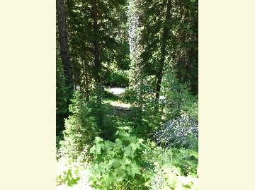
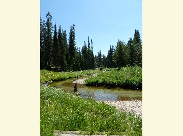
The West Eagle Meadow Campground is set amongst towering evergreen forests and across from wildflower covered meadows. The icy cold West Eagle Creek flows near the sites after it leaves the Eagle Cap Wilderness. The campground offers tent/small trailer campsites, walk-in tent sites, and a picnic area. Adjacent to the campground in the West Eagle Meadows Trailhead which has a combination horse camp and trailhead.

At a Glance
| Reservations: | This site is not reservable. |
|---|---|
| Area Amenities: | Tent camping, Camping trailer, Fee charged for some activities, Picnic tables, Toilets |
| Fees: | Although the daily vehicle parking fee for both the campground and trailhead is $5.00/day, there are actually 2 separate fee sites. The trailhead fee can be covered with a Northwest Forest Pass or any form of the America the Beautiful National Pass. Passes can be obtained before you visit at these websites and locations. You can also use the self-service fee station which is located at the site for purchasing day passes. The campground fee is $10.00/night for users staying in the designated campsites. A self-service fee station is located near the information board. Visitors parking at the site in either the campsites or trailhead parking areas and spending extended time in the backcountry will need to have multiple day passes (or an annual pass for trailhead use). |
| Permit Info: | All visitors to the Eagle Cap Wilderness must obtain a Wilderness Visitor Permit before entering the area. Only one permit is required per group and there is no fee for the permits. Registration and Permit boxes are located at each trailhead near the information board. The permits are self-issued. |
| Open Season: | July |
| Usage: | Light |
| Restrictions: | General rules of use and restrictions apply for this developed recreation site. Motorized vehicles, bicycles, carts, hand glider and other mechanical equipment is prohibited in the Wilderness area. |
| Closest Towns: | La Grande, Oregon (43 miles); Baker City, Oregon (34 miles) |
| Water: | No |
| Restroom: | Vault Toilet |
| Operated By: | Forest Service |
| Information Center: | La Grande Ranger District |
General Information
Directions:From La Grande, Oregon, travel south on State Highway 203 for about 14 miles to Union, Oregon; In Union turn left on East Beakman Street and continue on Highway 203 for 14 more miles to Catherine Creek Summit; At the summit turn left on Forest Road 77 and follow it for 15 miles to the campground entrance on your left side after the West Eagle Creek crossing.
From Baker City, Oregon head north on Interstate 84 for 5 miles to exit 298 (State Highway 203); Turn right off Interstate 84 to State 203 Highway and travel 18 miles to Medical Springs, Oregon; In Medical Springs turn right on Big Creek Road and go 1.5 miles to Forest Road 67; Turn left on Forest Road 67 and go about 14 miles to Forest Road 77; Turn left on Forest Road 77 and go about 5 miles to the campground entrance which is on your right before the West Eagle Creek crossing
Advisory: Forest Road 77 is gravelled, and the last 4 miles are extremely rough and not recommended for passenger cars or trailers.
Activities
Campground Camping
| No. of Sites | |
| Reservation Info | |
| No. of Accessible sites |
RV Camping
| Reservation Info | Not reservable |
| Pavement Type for Parking | No |
| Hookup - Water | No |
| Hookup - Sewer | No |
| Dump Stations | No |
| Hookups - Electric | No |
River and Stream Fishing
Day Hiking
Horse Riding
Picnicking
Amenities
| Camping trailer: | 5 tent/small trailer campsites |
|---|---|
| Picnic tables: | At each campsite |
| Tent camping: | 5 tent/trailer and 7 tent walk-in sites |
| Toilets: | Accesible vault toilet |
| Fee charged for some activities: | Overnight fee required |