
Official websites use .gov
A .gov
website belongs to an official government organization in the
United States.
Secure .gov websites use HTTPS
A lock
(
) or https:// means you've safely
connected to the .gov website. Share sensitive information only
on official, secure websites.


Mt. Thielsen Wilderness: Umpqua
Mt. Thielsen Wilderness encompasses 54,914 acres and runs along the crest of the Cascades 80 miles east of Roseburg and just north of Crater Lake National Park. Elevations range from 5,000' to the 9,182' summit of Mount Thielsen. Born of the same volcanic activity that created Crater Lake, this is the land of fire and ice.
Much of the Mount Thielsen Wilderness is made up of high alpine forests and open meadows. The terrain is moderate but becomes very steep toward the crest of the Cascade Mountains. Timberline stands at about 7,200 feet, just above a forest of mountain hemlock and fir mixed with whitebark pine. Lodgepole pine dominates the vegetation at lower elevations. The many streams in the area carry a substantial amount of snowmelt in spring.
The Pacific Crest National Scenic Trail winds through the Mount Thielsen Wilderness for 26 miles along the summit of the Cascade Range. For a more serene wilderness adventure, hike into Lake Lucille or Maidu Lake on the North Umpqua Trail #1414. The trail passes over deep pumice that was deposited when Mt. Mazama erupted to form Crater Lake. The famed North Umpqua Wild and Scenic River begins at Maidu on its long trek to the Pacific Ocean.
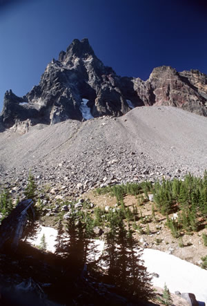
For the more experienced, the climb to the top of 9,182 foot Mt. Thielsen is a nice challenge. The Mount Thielsen Trail enters for approximately five miles from the west to rise above the tree line and, after 200 feet of hand-over-hand scrambling, finally reaches to within 80 feet of the summit and a breathtaking view. The summit itself requires a short technical climb. Sitting at the top of the sharp volcanic pinnacle, it is easy to see why Thielsen has been called "the lightning rod of the Cascades.
At a Glance
| Open Season: | Year Round |
|---|---|
| Restrictions: | Wilderness restrictions apply |
| Closest Towns: | Chiloquin, OR, Chemult, OR, Prospect, OR |
| Passes: | Some trailheads require a valid recreation pass. Check the Recreation Passes and Permits page for details. |
| Operated By: | Forest Service |
| Information Center: |
|
General Information
General Notes:Topo Maps
Burn Butte, Miller Lake, Mount Thielsen, Pumic Desert East, Tolo Mountain. Download free U.S. Forest Service Topo maps.
Buy maps online
Go to the USGS Store.
Wilderness.net
Go to Wilderness.net for online maps and other important Wilderness information.
Directions:
Trailheads/trails that access Mt. Thielsen Wilderness at Umpqua National Forest
- Howlock Mountain Trailhead – provides access to Howlock Mountain Trail #1448
- Kelsay Valley Horse Camp and Trailhead - provides access to Porcupine Connect Trail 1412A which links to North Umpqua Trail #1414.11 Maidu Segment, and Windigo Pass Trail #1412.
- Mt. Thielsen Trailhead / Sno-Park – provides access to Mt. Thielsen Trail #1456.
- North Crater Trailhead/Sno-Park - provides access to Pacific Crest National Scenic Trail #2000.
- Tipsoo Peak Trailhead - provides access to Tipsoo Peak Trail #1472.
- Windigo Pass Trailhead – provides access to Pacific Crest National Scenic Trail #2000 and Windigo Pass Trail #1412.
Other trails within Mt. Thielsen Wilderness at Umpqua National Forest
- Lucile Lake Trail #1459 (area is unavailable)
- Maidu Lake Loop Trail (via North Umpqua Trail)
- Six Horse Trail #1411 (via Pacific Crest Trail)
- Tenas Peak Trail #1445
- Thielsen Creek Trail #1449
- Tolo Creek Trail #1466
See also:
- Fremont-Winema National Forest Mount Thielsen Wilderness information.
- Deschutes-Ochoco National Forest Mount Thielsen Wilderness information.