
Official websites use .gov
A .gov
website belongs to an official government organization in the
United States.
Secure .gov websites use HTTPS
A lock
(
) or https:// means you've safely
connected to the .gov website. Share sensitive information only
on official, secure websites.


Bartlett Reservoir
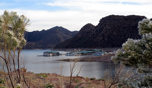
The Bartlett Reservoir area is noted for the spectacular vistas of the Desert Mountains and the Sonoran plant life. A fair portion of the west side of the reservoir is devoted to camping and picnicking. Bartlett has been a favorite with anglers since Bartlett Dam was constructed in 1939. Several state-record fish have been caught there. The 1977 Small-mouth Bass state record tipped the scales at seven pounds. The carp state record still stands at 37 lbs. 5 oz. Flathead Catfish lurk in the depths. “Fish City” near Bartlett Flat is a fish-habitat improvement project.
At a Glance
| Current Conditions: | CLOSED due to the Boulder View Fire. Bartlett Dam Road is closed at Cave Creek Road. Bartlett Lake Recreation Area has not been evacuated. PUBLIC HEALTH ADVISORY: Harmful algae bloom in Bartlett Reservoir Lake |
|---|---|
| Permit Info: | Group events like fishing tournaments require a permit. Contact the local Ranger District. |
| Open Season: | Year-round, as water levels permit |
| Restrictions: |
|
| Closest Towns: | Cave Creek and Fountain Hills |
| Water: | Available at Bartlett Lake Marina off of Horseshoe Dam Rd. & various recreation sites around lake |
| Restroom: | Available at Bartlett Lake Marina off of Horseshoe Dam Rd. & various recreation sites around lake |
| Passes: | America the Beautiful Passes are only accepted at the Picnicking Sites. For boating, a Tonto Daily Pass and Watercraft Sticker or Tonto Discovery Pass are required. ampground fees at various sites around Bartlett Reservoir might be separate from the Tonto Daily and Discovery pass. Please call Cave Creek Ranger District for specific details or visit individual websites |
| Information Center: | Cave Creek Ranger District (480)-595-3300 |
General Information
Directions:The reservoir is 20 miles east of Carefree. From Carefree, take the Cave Creek Road/Forest Road (FR) 24 to the Bartlett Road/FR 19 junction. Turn right on this paved highway; it is 13 miles to the reservoir.
Activities
Lake and Pond Fishing
Fish Species: Large and Smallmouth Bass; Crappie; Sunfish; Channel and Flathead Catfish
| Fish Species | Crappie, Large and Small-mouth Bass, Channel and Flathead Catfish, Carp, Bluegill, and Green Sunfish. |
Picnicking
Picnicking ramadas are available at Rattlesnake Cove and Yellow Cliffs.
Boating - Motorized
Boat Launching Sites: Jojoba, Bartlett Flat, Bartlett Marina, Yellow Cliffs
| Water/Flow Level | Counter clock wise |
Boating - Non-Motorized
Boat Launching Sites: Jojoba, Bartlett Flat, Bartlett Marina, Yellow Cliffs
| Water/Flow Level | Counter clock wise |
Waterskiing
- All Tonto National Forest reservoirs (with the exception of Horseshoe Reservoir) are open to water-skiing.
- Saguaro and Canyon Lakes are the most popular and both are very busy during the warmer months.
- As a result of the heavy use, Bartlett, Saguaro, and Canyon lakes are limited in the number of boats allowed on them. On summer weekends, consider arriving early in the day to secure your spot.
- Theodore Roosevelt is the largest of the Tonto's reservoirs; therefore, the capacity is higher and it is reached only on holiday weekends. Consider driving a little farther and discover the many miles of shoreline at Theodore Roosevelt Lake.
- Many coves are 'No-Wake' areas. Please obey these areas marked by buoys.
- Arizona boating laws are in effect.

Location