
Official websites use .gov
A .gov
website belongs to an official government organization in the
United States.
Secure .gov websites use HTTPS
A lock
(
) or https:// means you've safely
connected to the .gov website. Share sensitive information only
on official, secure websites.


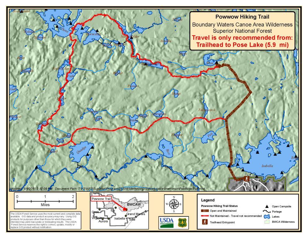
Powwow Trail
The Powwow Trail was constructed in 1978-9 and is located in a remote part of the Boundary Waters Canoe Area Wilderness (BWCAW) on the Superior National Forest.
The trail is shaped like a lollipop beginning with a three mile out-and-back stem, leading to a 25-mile loop. The trail is generally considered challenging due to the trail tread being obscured at times but offers a wilderness day hiking or overnight backpacking experience, a dynamic ecosystem with a variety of vegetative conditions, scenic overlooks, wetlands, and water crossings.
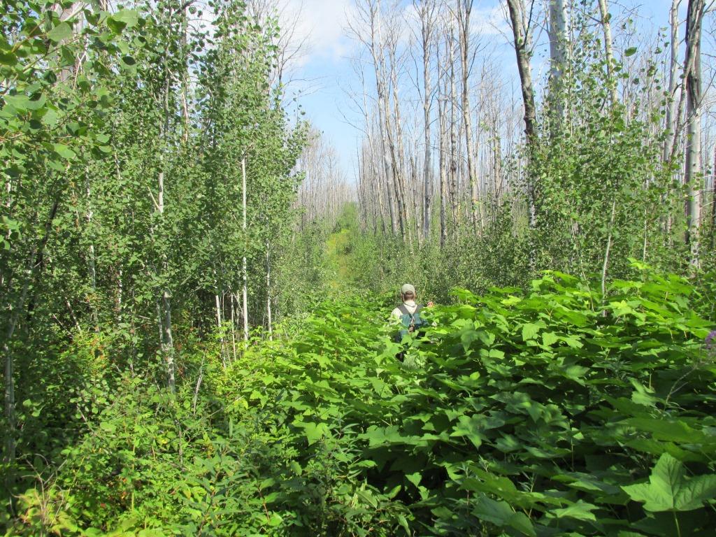
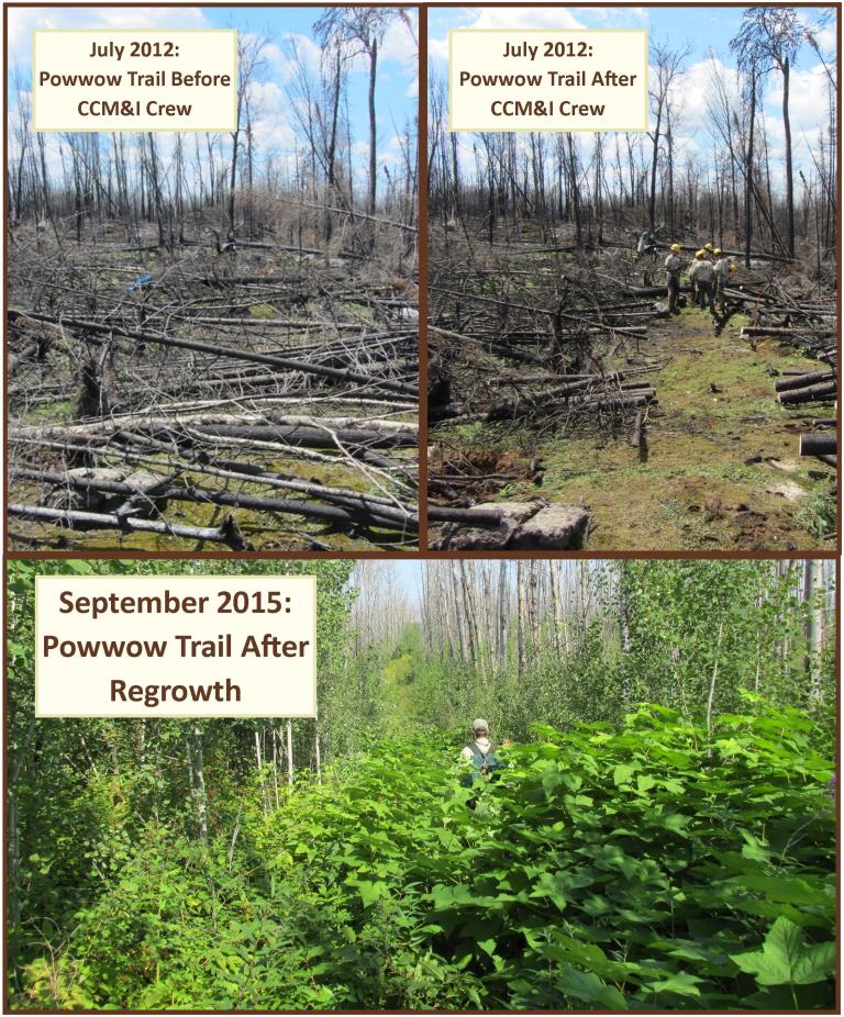
The trail was heavily impacted from the 2011 Pagami Creek Wildfire, killing most of the overstory trees. The resulting open conditions have led to heavy regrowth, with many of the standing dead trees now fallen. Be advised that there is now little to no shade, less live trees for hanging food packs, and poor footing due to growth and deadfall.
Since the fire, the Forest Service, numerous dedicated volunteers, and the Conservation Corp of Minnesota and Iowa have made a concerted effort to maintain the trail. In 2012, 21 miles of the trail were cleared of deadfalls caused by the fire. The remaining six miles on the north side of the loop between Pose Lake and Lake Three were cleared in May of 2015. Additionally, the trail was re-cleared between the trailhead and Pose Lake in 2015, and again in the spring andfall of 2016. Despite this massive effort, regrowth has made a large portion of the original 27 miles challenging to hike. Plan ahead and prepare for your hiking or backpacking experience.
Visit the Boundary Waters Canoe Area Wilderness section of our website for information and regulations regarding traveling in the wilderness.
At a Glance
| Current Conditions: | For the latest trail conditions, please contact the Tofte Ranger District or visit Trail Conditions |
|---|---|
| Fees: | For over night travel May 1st to September 30th -
|
| Permit Info: |
|
| Usage: | Light |
| Restrictions: | Camp 150 feet from the trail and bodies of water. |
| Closest Towns: | Isabella |
| Water: | No potable water available – lake water must be treated. |
| Passes: | Interagency senior and access pass information can be found on the Passes and Permits page of the website. |
| Information Center: | Tofte Ranger District Email | Call | Address | Webpage |
General Information
Directions:Follow the directional signs to Isabella Lake.
From Isabella
- Travel on County 1, turn onto FR 172 (Wanless Road).
- From 172, go north on FR 369.
- Veer left on FR 373, then right on FR 377.
- Park in the Isabella Lake Entry Point parking lot.
The trailhead is not the same as the portage to Isabella Lake. The Powwow Trail trailhead is from the southwestern end of the parking lot.
General Notes:
 Map Information
Hikers should download a map showing the trail route with the two sections, and a zip file containing GPX and GDB files usable on many GPS units.
This map is not intended to be used as a trail map, be sure to have larger more detailed topographic maps when you hike. Do not rely on GPS as a primary source of navigation information, always carry a map and compass.
Be prepared for a post fire environment
You will be able to experience first-hand a forest in the process of recovering after a natural wildfire caused by lightning.
- There will be little shade.
- There will be few trees for hanging food packs, bring alternative ways to 'bear proof' your campsite.
- It may seem counterintuitive, but there will not be a lot of wood for campfires, and we ask that you limit your use of what wood there is.
- Nutrients in rotting wood are important for forest regeneration, so you should plan to use a cookstove as much as possible.
Camping 150 feet from the trail or a body of water is allowed. Standing dead snags are becoming unstable with the passage of time as roots rot. Before making camp, scan for these dead snags, and do not camp where one could fall on you. There is one designated campsite on the trail at Pose Lake.
Parking:
Parking lot is the Isabella Lake enrty point for the BWCAW.
Activities
Day Hiking
Backpacking
| Permit required?: | Y |
|---|---|
| Difficulty Level: | More Difficult |


Related Information
Location


