
Official websites use .gov
A .gov
website belongs to an official government organization in the
United States.
Secure .gov websites use HTTPS
A lock
(
) or https:// means you've safely
connected to the .gov website. Share sensitive information only
on official, secure websites.


Boundary Waters Canoe Area Wilderness
Established in 1964 as Federally Designated Wilderness (pdf), the Boundary Waters Canoe Area Wilderness is over one million acres of rugged and remote boreal forest in the northern third of the Superior National Forest in northeastern Minnesota.
The BWCAW extends nearly 150 miles along the International Boundary, adjacent to Canada’s Quetico and La Verendrye Provincial Parks, is bordered on the west by Voyageurs National Park, and by Grand Portage National Monument to the east. The BWCAW contains over 1,200 miles of canoe routes, 12 hiking trails and 2,000 designated campsites. The BWCAW is composed of lakes, islands, rocky outcrops and forest.
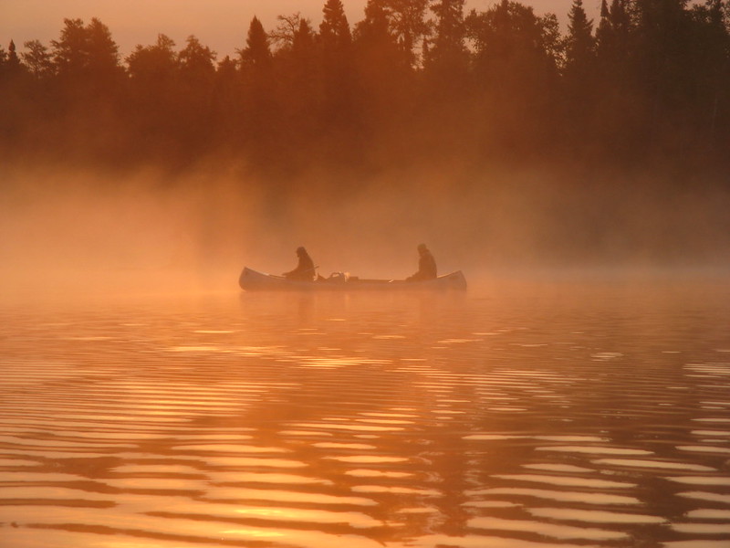
The BWCAW is the only large temperate lake-land wilderness in the National Wilderness Preservation System and is renowned for its water-based recreational opportunities. The sculpting of the landscape by powerful glaciers over an immense period of time has left behind a variety of landforms and rocks as well as thousands of lakes and streams, interspersed with islands. This network of connecting waterbodies provides unique opportunities for long distance travel by watercraft—a rare experience within the continental United States.
Prepare for your Wilderness Trip
Successful trips don't just happen. Plan ahead for the BWCAW! Visitors can find solitude, adventure, risk, and excitement but the trip planning begins months before entering the Wilderness.
The BWCA Wilderness is one of the most visited wilderness areas in the country. High visitation translates to the potential for impacts to natural resources. We need your help treading lightly on the Wilderness; to keep it full of solitude and pristine for future visitors like you.
Prior to reserving your permit, please review the following to ensure a wilderness trip is right for you:
Be aware that wilderness has inherent dangers, and is a primitive setting where you meet nature on its own terms. Trails are not well marked, if they are marked at all. If you are a newcomer to camping, or even an experienced backpacker, but not canoe camper, consider camping outside of the BWCAW on one of the 254 backcountry sites on the Forest, or one of our free rustic campgrounds. There you can experience many of the same things as you do in the Wilderness, but without the need for permits and with easier access to emergency services.
More About Boundary Waters Canoe Area Wilderness
At a Glance
| Current Conditions: | June 18, 2024 Storm Closures
Multiple entry points are closed. Permits have been canceled through June 22 for Stuart River #19, Angleworm #20 and #21, South Hegman #77. Permits have been canceled through June 25 for Trout Lake #1, Slim Lake #7, Mudro Lake #23, Bog Lake #67, Island River #34, Isabella Lake #35, and Pow Wow Trail #86. Please check Alerts and Closures for updates.
Previous Fires
|
|---|---|
| Reservations: | May 1 to September 30
|
| Rentals & Guides: | There are multiple outfitters and guides operating on BWCAW under a special use permit. |
| Fees: | Permits
|
| Permit Info: | A permit is always required to enter the BWCAW.
|
| Open Season: | January - December |
| Usage: | Heavy |
| Restrictions: | BWCAW Leave No Trace Video Series Permit holders are responsible for sharing the BWCAW Leave No Trace Video Series with their group prior to departure:
|
| Closest Towns: |
|
| Water: | No potable water available, boil or filter lake water |
| Restroom: | Wilderness latrines available at campsites |
| Operated By: | USDA Forest Service |
| Information Center: | Office Addresses Gunflint Ranger District Email | Call Kawishiwi Ranger District Email | Call LaCroix Ranger District Email | Call Tofte Ranger District Email | Call |
General Information
Directions:Recreation.gov Interactive Map
Recreation.gov interactive entry point map. Scroll down for the map. (html)
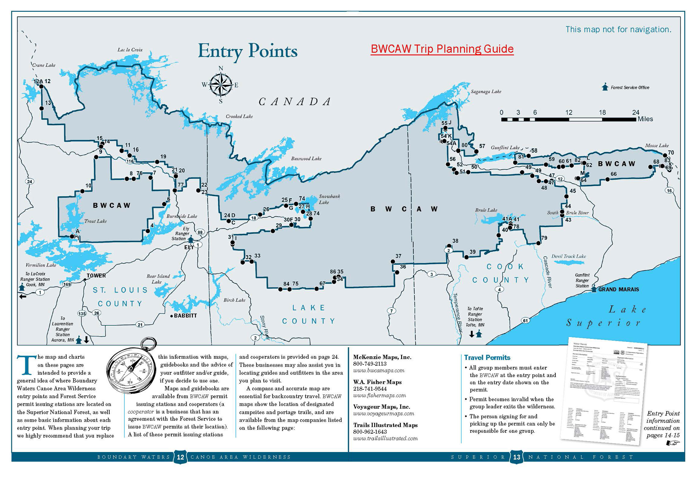
Trip Planning Guide Map
Expand the Entry Point Map (jpg)
BWCAW Trip Planning Guide (pages 12 and 13)(pdf)
General Notes:
Before you reserve your permit, do your research! Be prepared and have several potential trips in mind in case permits are unavailable for your desired dates and entry point. Review the BWCAW Trip Planning Guide for tips on wilderness preparation.
Choose your activity (see full list below):
- Wilderness Camping
- Fishing
- Day Hiking and Day Trips
- Backpacking
- Non-motorized Boating – Canoeing, Kayaking
- Motorized Boating
- US-Canada Wilderness Travel
Reserve your permit on Recreation.gov
- Permits go quickly, planning in advance is recommended if you would like to reserve a specific entry point. You will also need to identify your issue station when you make your reservation.
- TIP: Before reserving your permit, review the permit issue station locations and hours of operations by clicking on the arrow next to the Issuer listed under the Cooperators tab on Recreation.gov. Be sure to select an issue station near your entry point, the BWCA Wilderness is over one million acres in size.
Prepare for your trip
- Watch the first two Forest Service Leave No Trace videos and review Leave No Trace principles before picking up your permit.
Pack! Ensure you have the appropriate gear, food and bear-resistant storage for food and toiletries, maps (don’t rely on cell phones or GPS as cell service is spotty) and first aid kits.- There are no signs in the wilderness; ensure you have the correct maps, a planned route and know how to use a compass.
- If you are looking for additional support with trip planning or gear, there are many outfitters and guides available to help.
Picking up your permit
- Ensure your trip leader or alternate is ready to pick up your permit on the day of your trip or one day prior at the issue station selected in Recreation.gov. Please call a Forest Service district office if you need to change your issue station due to an unforeseen circumstance.
- Always communicate your travel plans with friends and family and notify them when you come out of the Wilderness.
International Travel
The US-Canada Border is open, however Canada is not allowing Remote Area Border Crossing at this time. Please visit the links below for the most up to date information:
Wilderness Volunteers
Contact Northwoods Volunteer Connection or your local Forest Service office
Parking:
Parking may be available at entry points, or adjacent to entry points. Please call your issue station for entry point specific parking information.
Activities
Dispersed Camping
There are over 2,000 designated wilderness campsites in the BWCAW. Each campsite has a wilderness latrine and fire grate. All campsites are first come, first served. Page 13 of the BWCAW Trip Planning Guide has a list of map resources for visitors.
Wilderness camping is a unique experience! Be prepared to stargaze, brave the elements and listen to the birds around you.
BWCAW Tip
Do not throw garbage in fire grates or latrines for others to find and our Wilderness Rangers to pick up. Pack out what you bring in. Sound carries well over water, so please be kind to your BWCAW neighbors by keeping noise down.
Lake and Pond Fishing
There are more than 1,100 lakes and several hundred streams in the BWCAW, providing excellent fishing opportunities for species like northern pike, walleye, bass and lake trout. Visitors must have a valid Minnesota DNR permit to fish in the BWCAW. Page 13 of the BWCAW Trip Planning Guide has a list of map resources for visitors.
BWCAW Tip
Dispose of fish remains at least 200 feet from campsites, trails, portages and shoreline and please don’t dump bait, it is considered littering.
Day Hiking
Day hiking in the BWCAW provides visitors a snapshot of the Wilderness landscape - rocky outcrops, streams and lakes. Hikes range from moderate to strenuous. BWCAW backpacking trails can also be used for shorter day hikes. Self-issued permits are required for day-use and can be found at entry points or any Forest Service office. Several of these trails begin in the Forest and end in the Wilderness, requiring a day-use permit. Page 13 of the BWCAW Trip Planning Guide has a list of map resources for visitors.
Areas for Day Hiking at Boundary Waters Canoe Area Wilderness
- Angleworm Hiking Trail
- Big Moose Trail
- Border Route Trail
- Brule Lake Trail
- Caribou Rock Trail
- Eagle Mountain Trail
- Herriman Lake Trail
- Kekekabic Trail East
- Kekekabic Trail West
- North Arm Trails
- Norway Trail
- Powwow Trail
- Sioux-Hustler Trail
- South Lake Trail
Backpacking
The BWCAW is renowned for its paddling and portaging, but it also offers over 160 miles of backpacking trails. Trails range from 2.5 miles and moderate to 53 miles and very strenuous. Some trails are entirely in the BWCAW, while others begin in the Forest and end in the Wilderness. A permit is required for any entry into the BWCAW. Page 13 of the BWCAW Trip Planning Guide has a list of map resources for visitors.
BWCAW Tip
Map and compass recommended. Boil or filter water for drinking. Campsites along trails offer wilderness latrines and fire grates. Backpackers should camp 150 feet from the trail and bodies of water.
Areas for Backpacking at Boundary Waters Canoe Area Wilderness
Boating - Motorized
The Boundary Waters Canoe Area Wilderness Act of 1978 allows for limited motorized boating in select lakes or areas of certain lakes that straddle the Forest and Wilderness. A permit is required for any motorized day-use or overnight trips. Motorized entry points also serve as overnight paddle entry points.
Visit page 13 of the BWCAW Trip Planning Guide for more entry point information.
Day-use motor entry points
- Clearwater Lake
- East Bearskin
- Saganaga Lake
- Seagull Lake
- Fall Lake ONLY
- Fall Lake and beyond
- Moose Newfound Sucker
- Moose-Basswood via Prairie Portage
- Snowbank Lake
- South Farm Lake
- Little Vermillion Lake and beyond
- Trout Lake
Overnight motor entry points
- Clearwater Lake
- East Bearskin
- Saganaga Lake
- Seagull Lake
- Fall Lake
Boating - Non-Motorized
The BWCAW offers more than 1,200 miles of canoe routes and 190,000 acres of surface water. Some visitors kayak in the Wilderness, however many opt for a canoe because its ability to carry gear and supplies. To find a map of portaging routes, visit page 13 of the BWCAW Trip Planning Guide for a list of resources. Visit Recreation.gov for a list of overnight paddling entry points. A map of entry points available on Recreation.gov and on this page (see directions section).
BWCAW Tip
Canoeing in the Wilderness can be a serene experience; however during wind events or stormy conditions, it can be very challenging; always wear a life jacket when on the water.
General Info:
Permits & RegulationsThe Boundary Waters Canoe Area Wilderness (BWCAW) permit reservations for the 2024 quota season, May 1 – September 30, will be available beginning at 9:00 a.m. CST on Wednesday, January 31, 2024. Visitors are encouraged to book their reservations online at www.recreation.gov/. Reservations may also be made by calling 1-877-444-6777.
XC Skiing/Snowshoeing
North Arm Ski Trails
Most of the trails venture into the Boundary Waters Canoe Area Wilderness - if you enter the BWCAW, you will need to fill out a use permit available, usually available at a self-serve kiosk where the trails begin.
South Farm Lake Ski Trails
The entire trail is in the Boundary Waters Canoe Area Wilderness, so skiers must pick up a self issuing wilderness entry permit at the trailhead or other location.
Areas for XC Skiing/Snowshoeing at Boundary Waters Canoe Area Wilderness


Related Information
Location


