
Official websites use .gov
A .gov
website belongs to an official government organization in the
United States.
Secure .gov websites use HTTPS
A lock
(
) or https:// means you've safely
connected to the .gov website. Share sensitive information only
on official, secure websites.


Absaroka-Beartooth Wilderness: Shoshone
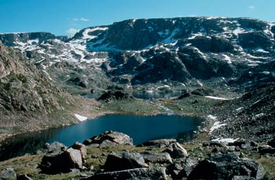
The United States Congress designated the Absaroka-Beartooth Wilderness in 1978 and it now has a total of 943,648 acres. Spanning the Montana-Wyoming border on the Shoshone, Gallatin, and Custer National Forests, the Absaroka Beartooth Wilderness is the juncture of two mountain ranges (Beartooth and Absaroka) with differing geologic types.
The Absaroka Range (prounounced ab-ZORE-kuh, the Crow Indian word for crow) is of volcanic origin, while the Beartooth Range, named for a spike of rock resembling a bear's tooth, is granitic in formation.
The extremely rugged and picturesque topography contains hundreds of lakes, high-rolling plateaus, and deep, glacier-carved valleys. Granite Peak, Montana's highest point at 12,799 feet, is located near the Wyoming-Montana border. This area also is known for several grasshopper glaciers, glaciers containing millions of grasshoppers frozen in ice.
Please view the special regulations associated with Wilderness and always use Leave No Trace techniques to help keep this area wild, clean, and pristine.
- Wilderness.net: Absorka-Beartooth Wilderness.net web page
At a Glance
| Usage: | Medium |
|---|---|
| Restrictions: | Wilderness regulations apply |
| Closest Towns: | Cody, WY; Livingston, MT; Gardiner, MT; Red Lodge, MT |
| Water: | Treat all non-potable water before consuming |
| Operated By: | Forest Service |
| Information Center: | Shoshone National Forest, (307) 527 6241
|
General Information
General Notes:Topo maps
Forest Service Topography Maps: These maps overlay Forest Service assets, such as roads, trails, and campgrounds, on USGS's topographic maps. They are available for download by quadrangle.
Buy maps online
National Forest Store: Offers a full, nationwide selection of National Forest, Ranger District, Wilderness, and Specialty Maps for purchase online or by phone, fax, and mail.
Wilderness.net
Go to Wilderness.net for additional maps and information about Wilderness.


