
Official websites use .gov
A .gov
website belongs to an official government organization in the
United States.
Secure .gov websites use HTTPS
A lock
(
) or https:// means you've safely
connected to the .gov website. Share sensitive information only
on official, secure websites.


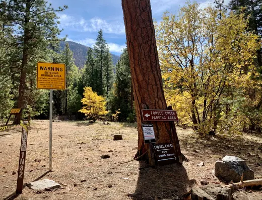
Forsee Creek Trail 1E06
Three-quarters to one mile up the trail is the cutoff for John's Meadow (heading to the west). John's Meadow (and camp) is located at 7,200' and 2.7 miles from the trailhead. Plenty of water is available here year-round.
Four miles from the trailhead (6,400') is Jackstraw Camp. Jackstraw Camp (9,200') is located .2 miles to the right (west) of the trail and is supplied by a small and intermittent water source. One and nine-tenths miles beyond Jackstraw is Trail Fork Springs Camp (10,400'). Water is located about 100 yards southwest of the camp at the Spring.
To the east along the Peak Divide Trail lie two additional camps. The first, Anderson Flat (no water-10,500'), is .4 miles up the trail. The second is Shields Flat (no water-10,400') 1.8 miles east of Anderson Flat, 2.3 miles east of Trail Fork, and only 1.2 miles west of High Meadow Spring (10,300') which is the preferred water source. This trail is mostly shaded up to Jackstraw Springs Camp, and offers outstanding sunset views west from Trail Fork Springs Camp.
At a Glance
| Current Conditions: |
|
|---|---|
| Permit Info: | Wilderness Permit Required |
| Restrictions: |
 Pack out what you pack in and Leave no Trace! Pack out what you pack in and Leave no Trace! |
| Closest Towns: | Angelus Oaks |
| Information Center: | Mill Creek Visitor Center 34701 Mill Creek Road Mentone, CA 92359 1-909-382-2882 Thursday thru Monday. (Closed Tuesdays and Wednesdays) |
General Information
Directions: Turn right (southeast) on Jenks Lake Road West off of Highway 38. One-quarter mile from Highway 38 is a signed dirt road on your right. This is a rough, rocky road not intended for low-slung autos, but is usually passable.Activities
Day Hiking
Backpacking


Location