
Official websites use .gov
A .gov
website belongs to an official government organization in the
United States.
Secure .gov websites use HTTPS
A lock
(
) or https:// means you've safely
connected to the .gov website. Share sensitive information only
on official, secure websites.


East Bellows Trailhead # 790
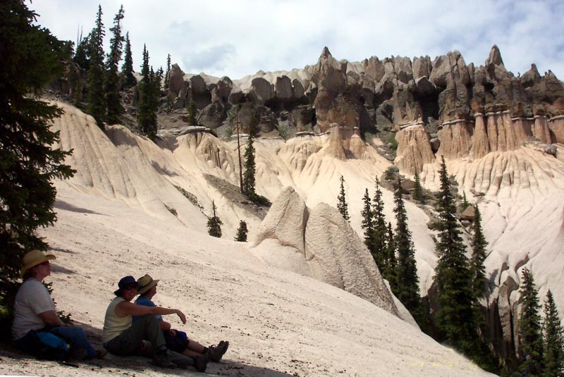
This trail provides good hiking and horseback access to Wheeler Geologic Area, Halfmoon Pass and the La Garita Wilderness. Beautiful views and unique geologic features are the main attractions of this trail. Decent camping areas are not hard to find. Opportunities for fishing exist in East Bellows Creek. This trail allows for a good overnight backpack visit to Wheeler Geologic Area. Camping is allowed only in designated sites. No campfires are allowed within the Wheeler Geologic Area.
After arriving at Hanson’s Mill, those planning to hike to Wheeler Geologic Area should follow the trail delineated with the trailhead sign and registration box. This trail is closed to all motorized use and closed to mountain bike use after crossing East Bellows Creek as it then passes through the La Garita Wilderness.
Within about three miles from Hansons Mill the trail will cross East Bellows Creek. The old sheep bridge is no longer usable, so hikers may get their feet wet. Crossings in the early summer can be dangerous. After the creek crossing, the trail will head up the west fork of East Bellows Creek, Canon Nieve.
The trail joins the 4WD road about 1.5 miles before the geologic formations. At this junction go left (west) and follow the road to its end at a pole fence in a small meadow below Wheeler Geologic Area. The unique, picturesque features of the geologic area are about 0.25 to 0.5 mile north from the end of the road. The foot trail to Wheeler will quickly meet the West Bellows Creek trail.
The trail into Wheeler from the end of the 4WD road is well marked. It is an easy to follow trail but difficult in elevation gain that will take you on a loop trail around the formations.
This trailhead consists of a parking lot, restroom, signing, picnic tables. Overnight camping is allowed at this trailhead. This is an ideal campsite if you have horses. There is lots of room for trailers and nearby grazing. No corrals but horses could be picketed out or put into portable panels or electric fences in nearby meadows.
At a Glance
| Operational Hours: | This trailhead is open year around but is usually snowed in between December and May each winter. |
|---|---|
| Area Amenities: | Interpretive Site, Picnic tables, Toilets, Parking |
| Fees: | No Fee |
| Open Season: | May |
| Usage: | Medium-Heavy |
| Best Season: | June to September |
| Busiest Season: | July |
| Restrictions: | No Motorized vehicles or motorcycles allowed on the trail into the Wilderness. |
| Closest Towns: | Creede, CO |
| Water: | No |
| Restroom: | Pit Toilet (1) |
| Operated By: | Forest Service |
General Information
Directions:DIRECTIONS FROM CREEDE, CO: Travel south on Colorado Highway 149 for 7.3 miles to FDR#600 (Pool Table Road). Go approximately 9.5 miles northwest on Pool Table Road to the Hanson’s Mill Trailhead. The speed Limit on all Forest Service Roads is 25 MPH unless otherwise posted.
Activities
Dispersed Camping
| Difficulty Level: | Easy to Intermediate |
|---|
River and Stream Fishing
| Difficulty Level: | Easy to Intermediate |
|---|
Day Hiking
Backpacking
| Difficulty Level: | Easy to Intermediate |
|---|
Horse Riding
| Difficulty Level: | Easy to Intermediate |
|---|
Amenities
| Interpretive Site: | at the trailhead |
|---|---|
| Picnic tables: | at the trailhead |
| Parking: | at the trailhead |
| Toilets: | at the trailhead |
Quick Links

Related Links
Location