
Official websites use .gov
A .gov
website belongs to an official government organization in the
United States.
Secure .gov websites use HTTPS
A lock
(
) or https:// means you've safely
connected to the .gov website. Share sensitive information only
on official, secure websites.


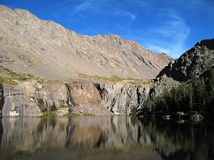
Sangre de Cristo Wilderness: Rio Grande
The 220,803 acre Sangre de Cristo Wilderness was designated by congress in 1993. All of this wilderness is located in Colorado and is managed by the Forest Service and the National Park Service. The Sangre de Cristo Wilderness is bordered by the Great Sand Dunes Wilderness to the west.
Sangre de Cristo is Spanish for "Blood of Christ," but no one is quite sure why the region was given this name. Was it because of the bloody hues washing the slopes at sunset, or the cry of the dying priest, "sangre de Cristo," as his martyred blood flowed onto the ground near here? Regardless, there is no doubt of the colorful Spanish influence in these mountains and in the San Luis Valley below. Two four-wheel drive roads over Medano Pass and Hayden Pass, as well as access to Lily Lake, were slim exclusions from wilderness designation and split the area into four distinct sections.
Unlike most of Colorado's mountains, the high and magnificently rugged Sangres were uplifted suddenly in massive blocks, creating a range of dramatic vertical proportions. Four fourteeners are clumped together in the midsection of the wilderness, including Crestone Needle (14,197 feet). Many climbers, consider the Needle to be Colorado's most challenging 14,000-foot peak. Three more fourteeners stand together just south of the boundary. Melting snow feeds many creeks and small lakes, and nourishes a forest of oak, aspen, and spruce. Black bears and mountain lions live here, along with elk, deer, and bighorn sheep.
The long and narrow Sangre de Cristo Wilderness is the state's third largest. Most of the 180 miles of trails end at alpine lakes set against virtually unclimbable walls.
Please always use Leave No Trace techniques to help keep these areas wild, clean, and pristine.
At a Glance
| Restrictions: | Wilderness restrictions apply. |
|---|---|
| Closest Towns: | Saguache, Colorado |
| Water: | Treat all non-potable water before consuming. |
| Operated By: | Forest Service; Park Service |
| Information Center: |
|
General Information
General Notes:Topo maps
Forest Service Topography Maps: These maps overlay Forest Service assets, such as roads, trails, and campgrounds, on USGS's topographic maps. They are available for download by quadrangle.
Buy maps online
National Forest Store: Offers a full, nationwide selection of National Forest, Ranger District, Wilderness, and Specialty Maps for purchase online or by phone, fax, and mail.
Colorado’s Fourteeners
Find more information about climbing Colorado’s peaks at the Rocky Mountain Region 14ers page.
Wilderness.net
Go to Wilderness.net for additional maps and information about Wilderness.
Directions:
See also:
- Pike and San Isabel National Forests Sangre De Cristo Wilderness information.
Activities
Day Hiking
Backpacking
Horse Riding

Current Conditions
- UTV Travel Etiquette Video
This excellent video explores numerous ways to enhance your OHV experience while making you a better land steward and respectful OHV user. - Colorado Avalanche Information Center
- Dispersed Camping Etiquette Video
This great video guides campers through the basics of being a good camper in areas away from the developed recreation sites. Learn how to be a respectable, conscientious camper. - Fire Conditions
- Multiple-use National Forest Video
- Conejos Peak District Roads

- Divide District Roads
- Saguache District Roads
-
Cumbres & LaManga Winter Recreation

