
Official websites use .gov
A .gov
website belongs to an official government organization in the
United States.
Secure .gov websites use HTTPS
A lock
(
) or https:// means you've safely
connected to the .gov website. Share sensitive information only
on official, secure websites.


Wrights Canyon Trail/Trailhead
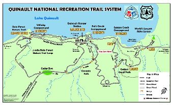
Quinault National Recreation Trail System vicinity map.
Provides access to: Gatton Creek Falls via Wrights Canyon Trail, a 3/10 mile compacted gravel accessible trail that leads to Gatton Creek Falls viewing area. The trail ends at its junction with Gatton Creek Trail #888 near the falls which allows continuous access from the Lake Quinault Lodge to the Rain Forest Village.
Small parking area with one accessible parking spot and information bulletin board.
To view all segments of the Quinault National Recreation Trail System explore the Quinault National Recreation Trail System interactive map.
At a Glance
| Fees: | No fee |
|---|---|
| Open Season: | Year-round |
| Usage: | Light-Medium |
| Closest Towns: | Aberdeen, WA |
| Water: | No |
| Restroom: | No |
| Operated By: | Forest Service |
| Information Center: | Pacific Ranger District, Quinault office |
General Information
Directions:From Aberdeen, WA drive Highway 101 north 41 miles to Quinault Lake South Shore Road (66 miles south of Forks.) Turn onto South Shore Road and drive about 2.6 miles and cross Gatton Creek Bridge. Then turn right on Forest Service Road 2272-160/Wright’s Canyon Road and drive ½ mile to the trailhead.
Accessibility:
Wrights Canyon Trail is compacted gravel. One accessible parking spot is available at the trailhead.