
Official websites use .gov
A .gov
website belongs to an official government organization in the
United States.
Secure .gov websites use HTTPS
A lock
(
) or https:// means you've safely
connected to the .gov website. Share sensitive information only
on official, secure websites.


Nantahala National Forest
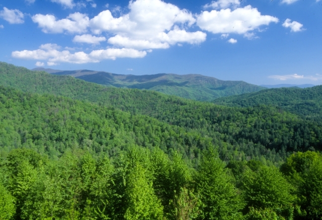
Welcome to the Nantahala National Forest! The Nantahala National Forest lies in the mountain and valleys of southwestern North Carolina. The largest of North Carolina's four National Forests, the Nantahala encompasses 531,148 acres with elevations ranging from 5,800 feet at Lone Bald in Jackson County to 1,200 feet in Cherokee County along Hiwassee River. The Forest is divided into three Districts, Cheoah in Robbinsville, NC, Tusquitee in Murphy, NC, and the Nantahala in Franklin, NC. All district names come from the Cherokee language. "Nantahala" is a Cherokee word meaning "land of the noon day sun," a fitting name for the Nantahala Gorge, where the sun only reaches to the valley floor at midday.The Nantahala National Forest was established in 1920 under authority of the 1911 Weeks Act. This act provided authority to acquire lands for national forests to protect watersheds, to provide timber, and to regulate the flow of navigable streams. In the Nantahala National Forest, visitors enjoy a wide variety of recreational activities from whitewater rafting to camping. With over 600 miles of trails, opportunities exist for hikers, mountain bikers, horse-back riders and off-highway vehicle riders.
Camping and Day-use Information
Enjoy camping or a picnic at one of the many day-use areas. A list of camping and day-use areas in the Nantahala National Forest can be found here.
Recreation Maps
Nantahala & Pisgah National Forest Maps
Be Safe
The national forests in North Carolina offer a wide variety of outdoor recreation opportunities. From the mountains to the sea, there are many exciting adventures awaiting your visit to these national forests. Please keep in mind that all outdoor recreational activities on the Croatan, Pisgah, Nantahala and Uwharrie national forests, including activities at recreation sites, have inherent risks due to the natural setting in which they occur. Always remember, your safety is your responsibility.
Activities
Mountain Biking
Areas for Mountain Biking at Nantahala National Forest
- Cheoah Ranger District
- Tsali Recreation Area
- Mouse Branch Loop #152A
- Thompson Connector #152B, Tsali
- Thompson Loop #152
- Tsali Left Loop #38A
- Tsali Right Loop #38
- Nantahala Ranger District
- Blackrock TR447
- Deep Gap TR 449
- Devils Elbow TR448
- Great Wall TR489
- Mac's Gap TR482
- Nantahala River Bike Trail TR368
- North Road TR 453
- Panthertown Valley Backcountry Area
- Panthertown Valley TR474
- Powerline Road TR451
- Rattlesnake Knob TR452
- Riding Ford TR 450
- Tusquitee Ranger District
- Hanging Dog Recreation Area
- Ramsey Bluff Mtn Biking System
- Jackrabbit Mountain Recreation Area
Road Cycling
Areas for Road Cycling at Nantahala National Forest
Campground Camping
Areas for Campground Camping at Nantahala National Forest
- Cheoah Ranger District
- Cheoah Point Recreation Area
- Horse Cove Campground
- Tsali Recreation Area
- Nantahala Ranger District
- Cullasaja Gorge
- Mountain Waters Scenic Byway
- Standing Indian Campground
- Van Hook Glade Campground
- Tusquitee Ranger District
- Jackrabbit Mountain Recreation Area
RV Camping
Areas for RV Camping at Nantahala National Forest
- Nantahala Ranger District
- Cullasaja Gorge
- Mountain Waters Scenic Byway
- Standing Indian Campground
- Van Hook Glade Campground
Group Camping
Areas for Group Camping at Nantahala National Forest
- Cheoah Ranger District
- Rattler Ford Group Campground
- Nantahala Ranger District
- Appletree Group Campground
- Kimsey Creek Group Campground
- Mountain Waters Scenic Byway
- Standing Indian Campground
Dispersed Camping
Areas for Dispersed Camping at Nantahala National Forest
- Cheoah Ranger District
- Joyce Kilmer Road NCSR #1134
- Long Hungry FDR #2586
- Panther Creek FDR #2604B
- Pine Ridge Road NCSR #1147
- Santeetlah Creek FDR #81
- Santeetlah Lake
- Snowbird Backcountry Area
- Snowbird Creek
- Wolf Laurel Hunters Camp FDR#81F
- Nantahala Ranger District
- Ammons Branch Campground
- Blue Valley Dispersed Camping
- Chattooga Wild and Scenic River
- Ellicott Rock Wilderness
- Hurricane Creek Horse & Primitive Campground
- Panthertown Valley Backcountry Area
- Wine Spring Horse Camp
- Tusquitee Ranger District
- Fires Creek Recreation Area
- Fires Creek Hunters Camp
Cabin Rentals
Areas for Cabin Rentals at Nantahala National Forest
Rock Climbing
Areas for Rock Climbing at Nantahala National Forest
Lake and Pond Fishing
Areas for Lake and Pond Fishing at Nantahala National Forest
- Cheoah Ranger District
- Cable Cove Recreation Area
- Cheoah Point Recreation Area
- Massey Branch Area
- Massey Branch Fishing Pier
- Tsali Recreation Area
- Nantahala Ranger District
- Balsam Lake Lodge
- Balsam Lake and Picnic Area
- Blue Valley Dispersed Camping
- Cliffside Lake and Day Use Area
- Cullasaja Gorge
- Fingerlake Day Use Area
- Van Hook Glade Campground
- Tusquitee Ranger District
- Bristol Fields Horse Camp
- Cherokee Lake Recreation Area
- Hanging Dog Recreation Area
- Jackrabbit Mountain Recreation Area
River and Stream Fishing
Areas for River and Stream Fishing at Nantahala National Forest
- Cheoah Ranger District
- Calderwood Reservoir
- Cheoah Reservoir
- Cheoah River Area
- Franks Creek
- Little Buffalo Creek
- Long Creek
- Mountain Creek
- Panther Creek
- Panthertown Creek
- Santeetlah Creek
- Sawyer Creek
- Snowbird Backcountry Area
- Big Snowbird Creek
- Snowbird Creek
- South Fork Squally Creek
- Squally Creek
- Stecoah Creek
- Tulula Creek
- West Buffalo Creek
- Yellow Creek
- Nantahala Ranger District
- Appletree Group Campground
- Balsam Lake and Picnic Area
- Chattooga Wild and Scenic River
- Cullasaja Gorge
- Hurricane Creek Horse & Primitive Campground
- Kimsey Creek Group Campground
- Mountain Waters Scenic Byway
- Nantahala River Ferebee Memorial Picnic Area and L
- Nantahala River Gorge
- Standing Indian Campground
- Van Hook Glade Campground
- Tusquitee Ranger District
- Buck Creek
- Davis Creek
- Dockery Creek
- Fires Creek Recreation Area
- Hyatt Creek
- Junaluska Creek
- Shuler Creek
- Tellico River
- Tusquitee Creek
Day Hiking
Areas for Day Hiking at Nantahala National Forest
- Cheoah Ranger District
- Appalachian Trail #1-02
- Big Fat Gap Trailhead
- Cable Cove Recreation Area
- Cable Cove Nature Trail #58
- Cable Gap Trail #403
- Cheoah River Area
- Belding Trail #52
- Yellow Creek Mountain Trail #48
- Cherohala Skyway Area
- Hooper Bald Trail #60
- Huckleberry Knob Trail #419
- Spirit Ridge Trail #420
- Strawberry Knob Trail #217H
- Fontana Area
- Bee Cove #421
- Brooks Cove Trail #422
- Fontana Loop Trail #157
- Lewellyn Cove Nature Trail #50
- Lookout Rock Trail #40
- Joyce Kilmer-Slickrock Wilderness Area
- Big Fat Trail #41
- Deep Creek Trail #46
- Hangover Alt. Trail #56A
- Hangover Lead Trail #56
- Haoe Lead Trail #53
- Ike Branch Trail #45
- Jenkins Meadow Trail #53A
- Joyce Kilmer Memorial Forest
- Joyce Kilmer Memorial Loop Trail #43
- Naked Ground Alt. Trail #55A
- Naked Ground Trail #55
- Nichols Cove Trail #44
- Slickrock Creek Trail #42
- Stratton Bald Trail #54
- Windy Gap Trail #400
- Yellow Hammer Gap Trail #49
- Locust Cove Trail #404
- Maple Springs Trail #71
- Massey Branch Area
- Cheoah Trail #407
- Massey Branch Fitness Trail #39
- Snowbird Backcountry Area
- Big Snowbird Trail #64
- Burntrock Ridge Trail #65A
- King Meadows Trail #63
- Middle Falls Alt. Trail #64B
- Middle Falls Trail #64A
- Mitchell Lick Trail #154
- Sassafras Creek Trail #65
- Snowbird Mountain Trail #415
- Tsali Recreation Area
- Mouse Branch Loop #152A
- Thompson Connector #152B, Tsali
- Thompson Loop #152
- Tsali Left Loop #38A
- Tsali Right Loop #38
- Wauchecha Bald #47
- Swan Cabin #2816
- Swan Meadows #81G
- Wolf Laurel Trail #57
- Nantahala Ranger District
- Albert Mountain Fire Tower
- Ammons Branch Campground
- Appalachian TR1
- Appletree TR19b
- Appletree Group Campground
- Balsam Lake Lodge
- Balsam Lake and Picnic Area
- Bear Pen Gap TR22
- Bearpen Gap TR442
- Beech Gap TR35
- Betty Creek Gap TR 367
- Big Creek Loop TR 492
- Big Green TR487
- Big Indian Loop TR34
- Big Laurel Falls TR29
- Blackrock TR447
- Blackwell Gap Loop TR366
- Blue Valley Dispersed Camping
- Blue Valley Route TR493
- Brush Creek Route TR 494
- Camp Branch TR 16a
- Camp Shortcut TR 36b
- Chattooga Loop TR 433
- Chattooga River TR432
- Chattooga Wild and Scenic River
- Chinquapin TR 3
- Clear Creek Loop TR 495
- Cliffside Lake and Day Use Area
- Cliffside Loop TR24
- Clifftop Nature TR 24f
- Clifftop Vista TR 24a
- Cullasaja Gorge
- Cullowhee TR370
- Deep Gap TR 449
- Devils Elbow TR448
- Diamond Valley TR19d
- Dry Falls TR 9
- Ellicott Rock Wilderness
- Ellicotts Rock TR431
- Foothills Trail TR436
- Glade Trail TR 430
- Glen Falls TR 8
- Granny Burrell Falls TR486
- Grap Cove TR 372
- Great Wall TR489
- Green Valley TR484
- Greenland Creek TR488
- Hickory Branch TR19a
- Homesite Road TR443
- Hurrah Ridge TR 4
- Hurricane Creek Horse & Primitive Campground
- Hurricane Creek Loop TR36
- Jones Knob TR67b
- Junaluska Gap TR19
- Kimsey Creek Group Campground
- Kimsey Creek TR 23
- Laurel Branch TR19f
- Little Green TR485
- Little Indian TR21
- Little Yellow Mountain Gap TR651
- Locust Tree TR16
- London Bald TR19c
- Long Branch TR86
- Lower Trail Ridge TR28
- Mac's Gap TR482
- Mooney Falls TR31
- Mooney Gap TR12
- Moss Gap Route TR 496
- Mountain Waters Scenic Byway
- Nantahala River Bike Trail TR368
- Nantahala River Gorge
- Nantahala Trail TR19e
- Nature Walk TR19g
- North Road TR 453
- Overlook TR491
- Panthertown Valley Backcountry Area
- Panthertown Valley TR474
- Park Creek Ridge Connector TR32a
- Park Creek TR33
- Park Ridge TR32
- Pickens Nose TR13
- Potts Memorial TR 24b
- Powerline Road TR451
- Rattlesnake Knob TR452
- Riding Ford TR 450
- Rocky Bald Loop TR 379B
- Rocky Bald TR18
- Rough Fork TR371
- Round Mountain Gap TR 497
- Rufus Morgan Falls TR27
- Scaly Mountain TR67a
- Shot Pouch TR17
- Siler Bald Shelter TR 373
- Siler Bald Vista TR373a
- Silver Run Falls TR435
- Skitty Creek TR 24e
- Slickrock TR 11
- Standing Indian Campground
- Standing Indian Picnic Area
- Stewart Cove TR 5a
- Stewart Cove/Yellow Mountain TR498
- Stewart TR15
- Thomas Branch TR375
- Timber Ridge Trail TR20
- Tuckaseegee Gorge TR438
- Turkey Knob TR 469
- Van Hook Glade Campground
- Van Hook TR 24c
- Walton Interpretive TR376
- Waslick Poplar TR30
- Wayah Bald TR 374
- Wayah Bald Tower
- Wesser Creek TR26
- Whiteside Mountain
- Whiteside Mountain TR70
- Whitewater Falls
- Whitewater Falls TR 7
- Whitewater River TR437
- Wildcat TR14
- Wilderness Falls TR490
- Wilson Lick TR369
- Wine Spring Horse Camp
- Wine Springs Loop TR 379A
- Wolf Creek Gorge TR439
- Yellow Mountain TR5
- Tusquitee Ranger District
- Bald Springs #78
- Beech Creek #378
- Big Scaley #638
- Billy Top #637, Near Andrews
- Bly Gap #84
- Bristol Fields Horse Camp
- Britton Creek #280
- Cherokee Lake #83, Cherokee Lake Recreation Area
- Choga #634, Near Andrews
- Deep Gap Branch #377
- Far Bald Springs #389
- Fires Creek Recreation Area
- Big Stamp #520, Fires Creek
- Bristol #76, Fires Creek
- Carroll Knob #633, Fires Creek
- Fires Creek Access #635, Fires Creek
- Huskins Branch #385, Fires Creek
- Leatherwood Loop #73, Fires Creek
- Little Fires Creek #386, Fires Creek
- Mingus #630, Fires Creek
- Omphus Ridge #75, Fires Creek
- Phillips Ridge #388, Fires Creek
- Rockhouse Creek #387, Fires Creek
- Shinbone #80, Fires Creek
- Shortoff #631, Fires Creek
- Hanging Dog Recreation Area
- Farmer Top Overlook #622, Hanging Dog Rec Area
- Nottely River Connector #623, Hanging Dog Rec Area
- Ramsey Bend Connector #619, Hanging Dog Rec Area
- Ramsey Bend North #620, Hanging Dog Rec Area
- Ramsey Bend South #621, Hanging Dog Rec Area
- Ramsey Bluff #81, Hanging Dog Rec Area
- Jackrabbit Mountain Recreation Area
- Burnt Tree Peninsula #753, Jackrabbit Mtn Rec Area
- Burrell Cove #756, Jackrabbit Mtn Rec Area
- Central Loop #750, Jackrabbit Mtn Rec Area
- High Point #755, Jackrabbit Mtn Rec Area
- Saba Beach #757, Jackrabbit Mtn Rec Area
- Saba Beach Spur #757A, Jackrabbit Mtn Rec Area
- Sneaking Creek #752, Jackrabbit Mtn Rec Area
- Upper Ridge #751, Jackrabbit Mtn Rec Area
- Yotee's Run #754, Jackrabbit Mtn Rec Area
- North Shoal Creek Falls #383
- Sasafrass #632
- Shoal Creek Falls #85
- Sledrunner #82
- Trail Branch #382
Backpacking
Areas for Backpacking at Nantahala National Forest
- Cheoah Ranger District
- Appalachian Trail #1-02
- Benton Mackaye #2-02
- Joyce Kilmer-Slickrock Wilderness Area
- Snowbird Backcountry Area
- Big Snowbird Trail #64
- Burntrock Ridge Trail #65A
- King Meadows Trail #63
- Middle Falls Alt. Trail #64B
- Mitchell Lick Trail #154
- Snowbird Mountain Trail #415
- Nantahala Ranger District
- Appalachian TR1
- Bartram Trail TR67
- Section 1 Beegum Gap to to Hickory Gap
- Section 2 Jones Gap to Buckeye Creek
- Section 3 Buckeye Creek to Wallace Branch
- Section 4 Wallace Branch to Wayah Bald
- Section 5 Wayah Bald to Nantahala Lake
- Section 6 Nantahala Lake to Nantahala River Gorge
- Section 7 Beechertown to Cheoah Bald
- Chattooga Wild and Scenic River
- Ellicott Rock Wilderness
- Hurricane Creek Horse & Primitive Campground
- Mountain Waters Scenic Byway
- Panthertown Valley Backcountry Area
- Park Creek TR33
- Standing Indian Campground
- Wayah Bald Tower
- Whitewater Falls
- Tusquitee Ranger District
- Chunky Gal Trail #77
- Fires Creek Recreation Area
- Fires Creek Rim Trail #72, Fires Creek
Horse Camping
Areas for Horse Camping at Nantahala National Forest
- Nantahala Ranger District
- Hurricane Creek Horse & Primitive Campground
- Panthertown Valley Backcountry Area
- Wine Spring Horse Camp
- Tusquitee Ranger District
- Bristol Fields Horse Camp
Horse Riding
Areas for Horse Riding at Nantahala National Forest
- Cheoah Ranger District
- Tsali Recreation Area
- Mouse Branch Loop #152A
- Thompson Loop #152
- Tsali Left Loop #38A
- Tsali Right Loop #38
- Nantahala Ranger District
- Big Indian Loop TR34
- Blackrock TR447
- Blackwell Gap Loop TR366
- Camp Shortcut TR 36b
- Deep Gap TR 449
- Devils Elbow TR448
- Great Wall TR489
- Hurricane Creek Horse & Primitive Campground
- Hurricane Creek Loop TR36
- Mountain Waters Scenic Byway
- North Road TR 453
- Panthertown Valley Backcountry Area
- Panthertown Valley TR474
- Powerline Road TR451
- Rattlesnake Knob TR452
- Riding Ford TR 450
- Rocky Bald Loop TR 379B
- Thomas Branch TR375
- Turkey Knob TR 469
- Wine Spring Horse Camp
- Wine Springs Loop TR 379A
- Tusquitee Ranger District
- Bristol Fields Horse Camp
- Fires Creek Recreation Area
Big Game Hunting
Areas for Big Game Hunting at Nantahala National Forest
- Tsali Recreation Area
- Nantahala Ranger District
- Hurricane Creek Horse & Primitive Campground
- Standing Indian Campground
Small Game Hunting
Areas for Small Game Hunting at Nantahala National Forest
Viewing Wildlife
Areas for Viewing Wildlife at Nantahala National Forest
- Nantahala Ranger District
- Blue Valley Dispersed Camping
- Hurricane Creek Horse & Primitive Campground
- Kimsey Creek Group Campground
- Panthertown Valley Backcountry Area
- Standing Indian Campground
- Whiteside Mountain
Viewing Plants
Areas for Viewing Plants at Nantahala National Forest
Viewing Scenery
Areas for Viewing Scenery at Nantahala National Forest
- Nantahala Ranger District
- Ammons Branch Campground
- Balsam Lake Lodge
- Chattooga Wild and Scenic River
- Cullasaja Gorge
- Dry Falls
- Kimsey Creek Group Campground
- Mountain Waters Scenic Byway
- Nantahala River Gorge
- Panthertown Valley Backcountry Area
- Standing Indian Campground
- Wayah Bald Tower
- Whiteside Mountain
- Whitewater Falls
OHV Trail Riding
Areas for OHV Trail Riding at Nantahala National Forest
Target Shooting
Areas for Target Shooting at Nantahala National Forest
Interpretive Areas
Areas for Interpretive Areas at Nantahala National Forest
Picnicking
Areas for Picnicking at Nantahala National Forest
- Cheoah Ranger District
- Cable Cove Recreation Area
- Cheoah Point Recreation Area
- Cheoah Point Beach
- Joyce Kilmer Memorial Forest
- Nantahala Ranger District
- Balsam Lake and Picnic Area
- Cliffside Lake and Day Use Area
- Cullasaja Gorge
- Dry Falls
- Fingerlake Day Use Area
- Mountain Waters Scenic Byway
- Nantahala River Ferebee Memorial Picnic Area and L
- Nantahala River Gorge
- Standing Indian Campground
- Standing Indian Picnic Area
- Wayah Bald Tower
- Whitewater Falls
- Tusquitee Ranger District
- Cherokee Lake Recreation Area
- Fires Creek Recreation Area
- Hanging Dog Recreation Area
- Jackrabbit Mountain Recreation Area
Group Picnicking
Areas for Group Picnicking at Nantahala National Forest
Scenic Driving
Areas for Scenic Driving at Nantahala National Forest
Boating - Motorized
Areas for Boating - Motorized at Nantahala National Forest
- Cheoah Ranger District
- Avey Branch Boat Launch
- Cable Cove Recreation Area
- Cheoah Point Recreation Area
- Lemmons Branch Boat Launch
- Massey Branch Area
- Tsali Recreation Area
- Tusquitee Ranger District
- Jackrabbit Mountain Recreation Area
Boating - Non-Motorized
Areas for Boating - Non-Motorized at Nantahala National Forest
- Cheoah Ranger District
- Avey Branch Boat Launch
- Cable Cove Recreation Area
- Cheoah Point Recreation Area
- Cheoah River Area
- Lemmons Branch Boat Launch
- Massey Branch Area
- Tsali Recreation Area
- Nantahala Ranger District
- Appletree Group Campground
- Balsam Lake Lodge
- Balsam Lake and Picnic Area
- Chattooga Wild and Scenic River
- Fingerlake Day Use Area
- Nantahala River Ferebee Memorial Picnic Area and L
- Nantahala River Gorge
- Tusquitee Ranger District
- Jackrabbit Mountain Recreation Area
Swimming
Areas for Swimming at Nantahala National Forest
- Cheoah Ranger District
- Cheoah Point Recreation Area
- Cheoah Point Beach
- Cheoah River Area
- Nantahala Ranger District
- Blue Valley Dispersed Camping
- Cliffside Lake and Day Use Area
- Fingerlake Day Use Area
- Van Hook Glade Campground
- Wilson Lake
- Tusquitee Ranger District
- Jackrabbit Mountain Recreation Area
Quick Links
- NFsNC District Offices

- Recreation Reservations
-
FY2019 Recreation Fee Program Accomplishment Highlights

-
FY2020 Recreation Fee Program Accomplishment Highlights
-
FY2018 Recreation Fee Program Accomplishment Highlights
-
FY2017 Recreation Fee Program Accomplishment Highlights
-
FY16 Recreation Fee Program Accomplishment Highlights
-
FY15 Recreation Fee Program Accomplishment Highlights
-
FY14 Recreation Fee Program Accomplishment Highlights
- Recreation Outfitters & Guides
Location