
Official websites use .gov
A .gov
website belongs to an official government organization in the
United States.
Secure .gov websites use HTTPS
A lock
(
) or https:// means you've safely
connected to the .gov website. Share sensitive information only
on official, secure websites.


Council Bluff Recreation Area
The Council Bluff Recreation Area, located next to the largest lake on the Mark Twain National Forest, is perfect for anyone looking to enjoy the outdoors. The area provides ample opportunities for camping, picnicking, hiking, fishing, swimming and more.
The site is large and spread out, the campground and beach are about a 1 mile hike apart, the hike/bike is downhill from the campground to the beach, but uphill coming back.
Located in southern Missouri, the Council Bluff Lake was created by a dam built across Big River. It is 440 acres in size and 87 feet deep in some places.
The Wild Boar Campground and sheltered picnic area are available for individual families or large groups.
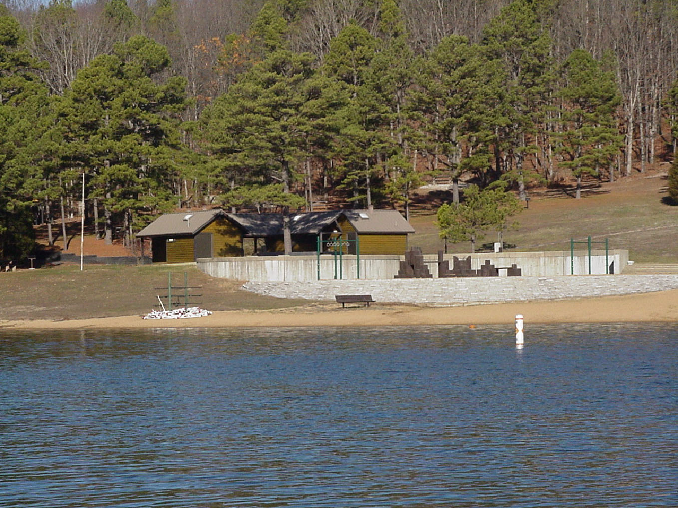
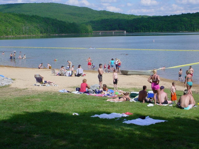
The Chapel Hill Beach is at the eastern end of the campground and provides 1.25 acres of sandy beach. The beach is accessible via a short walkway from the parking area.
Boating and paddling is a popular pastime on the lake, but all boats on the lake must operate at a no-wake speed. Visitors can access the water via the two boat ramps located at the lake.
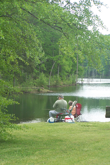
Fishing is also available. Anglers can expect a catch of a variety of freshwater fish, including bass, bluegills, catfish and crappies.
The 12-mile Council Bluff Trail encircles the lake, with spurs to the campground. Hikers can enjoy scenic views of the lake and a look at the Mark Twain wilderness. The Ozark Trail connects to the Council Bluff Trail at Trace Creek mile 15.
Waterfowl hunting is allowed on Council Bluff Lake and the nearby Enough Fields provide upland game opportunities. A variety of wildlife makes its home in the heavily wooded area.
A Printable Brochure and map is available.
At a Glance
| Operational Hours: | Campground Quiet Hours - 10 pm - 6 pm |
|---|---|
| Reservations: | Picnic Pavilion Reservations
|
| Area Amenities: | Accessible, Boat ramp, Tent camping, Camping trailer, Fee charged for some activities, Picnic tables, Toilets, Drinking water, Parking |
| Fees: | Day Use
|
| Open Season: | April 11 - October 31 |
| Usage: | Light-Medium |
| Busiest Season: | Memorial Day to Labor Day |
| Restrictions: |
|
| Closest Towns: | Belgrade, Caledonia |
| Water: | Drinking water |
| Restroom: | Vault in campground; Flush at beach |
| Passes: | Pass information can be found on the Passes and Permits page of the website. |
| Operated By: | USDA Forest Service and Concessionaire |
| Information Center: | Potosi-Fredericktown Ranger District Email | Phone and Address
|
General Information
Directions:Please note: Read the "directions" section below and before driving to the location enter "Council Bluff Campground" into your device as the destination; but do not just search for "Council Bluff". Searching for "Council Bluff" will bring up the lake and may cause your GPS to bring you in from the north, where the road is rough and you will need to turn around and re-route to the west side of the lake.
(Utilize this GPS coordinate to arrive at proper destination: 37.72261, -90.937792).
From Potosi,
- Go south 10 miles on Highway 21
- Turn right onto C Highway and go approximately 6 miles.
- Turn left on Highway DD for about 8 miles to the entrance, on the left, for Council Bluff Recreation Area.
Accessibility:
There are handicap parking spaces at the beach parking lot. The restrooms are handicap accessible at all locations.
The majority of the campsites are accessible, however, some sites have stairs down to them.
Activities
Sand Play
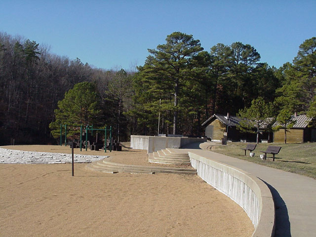
Recreation areas with activity Sand Play:There is a 1.25 acre sand beach in front of the concession stand, that can be busy on a hot weekend.
Kids can enjoy a small playground with a slide and climbing structures on the beach.
There is a paved sidewalk that winds around in front of the beach on a raised up embankment, and there are two sets of wide-stairs down to the beach area.
Amenities at the beach include a concession stand operated by the concessionaire, coin-operated private hot showers, flush toilets, water fountains and outdoor showers. There is one large and one small accessible picnic pavilions with tables and grills.
No lifeguard on duty.
Mountain Biking
Recreation areas with activity Mountain Biking:Council Bluff Lake Trail - 12-miles
The 12-mile long Council Bluff Trail encircles the lake, with spurs to the campground. There are some wet areas on the trail. There are a few places where trams have been installed in particularly wet areas.
Horses are prohibited from this section of the trail.
The trail can be accessed from the Wild Boar Hollow Boat Ramp Parking Lot and Enough Boat Launch, and there is a trailhead in the campground, look for it by the dumpster and horseshoe pit area.
Trace Creek Section of the Ozark Trail - 24-miles
Trace Creek Section of the Ozark Trail is located just west of the recreation area.
This section of the Ozark Trail is approximately 24 miles long and is open to foot, mountain bike, and equestrian traffic. From Hazel Creek in the north, it runs south crossing hollows, ridgetops, small streams, and several highways, ending at Hwy. A.
Campground Camping
Recreation areas with activity Campground Camping:Walk-in Sites – There are two sets of walk-in sites located back in the woods a little bit. One set is located on the north side of the campground, the other is on the south side. They offer a little more privacy than the sites on the campground loop road. There is a small parking area for these sites where you can park and hike in with your gear at each set of sites. Each site has a fire pit and a picnic table.
Campground Loop - There is one loop around the campground, with the group campsites located in the middle of the loop. The sites are screened with trees and brush to give a sense of privacy. Each site has a table, fire ring, lantern post and a parking spur.
Coin-operated hot showers available at Chapel Hill Beach. Some loops are one way traffic while others are two-way. Please be aware of traffic direction.
| No. of Sites |
|
| No. of Accessible sites | All of the sites, except the walk-in sites, are accessible. |
RV Camping
Recreation areas with activity RV Camping:Campground Loop - There is one loop around the campground, with the group campsites located in the middle of the loop. The sites are screened with trees and brush to give a sense of privacy. Each site has a table, fire ring, lantern post and a parking spur.
Coin-operated hot showers available at Chapel Hill Beach. Some loops are one way traffic while others are two-way. Please be aware of traffic direction.
No electric or water hookup, showers or dump station facilities.
| No. of Sites |
|
| Vehicle Clearence | No restrictions |
| Size Restrictions | Up to 40 feet at most sites. Check recreation.gov for specific length restrictions for sites. |
| Pavement Type of Parking | spurs are paved |
| No. of Accessible sites | All sites for RV camping are accessible. |
Group Camping
Recreation areas with activity Group Camping:4 group camp sites which can accommodate up to 50 people each. These sites can be busy on summer weekends.
There is one loop around the campground, with the group campsites located in the middle of the main loop.
- Loops A and D you pull directly off of the main loop road to park.
- Loops B and C have their own directional loops with parking.
The sites are screened with trees and brush to give a sense of privacy. Each site has a table, fire ring, lantern post and parking spurs.
Coin-operated hot showers available at Chapel Hill Beach.
Some loops are one way traffic while others are two-way. Please be aware of traffic direction.
| No. of Sites | Group sites: 4 |
| No. of Accessible sites | all group sites are accessible. |
Lake and Pond Fishing
Recreation areas with activity Lake and Pond Fishing:There are 2 boat launches on Council Bluff Lake: Wild Boar Hollow and Enough.
Over by the Enough boat launch there is an abundance of lily pads. Because this lake was built due to dam construction there are trees in the lake by this boat launch and around the perimeter of the lake. Once you are in the middle of the lake and by the beach there are few submerged trees from the flooding to create the lake.
If you are using a motorized watercraft it may be preferable to launch from Wild Boar Hollow.
Fishing is permitted year round. Fishing regulations are established by Missouri Department of Conservation.
| Fishing Mode | boat, shoreline |
| Fish Species | stocked with largemouth bass, red-ear, sunfish, bluegill, crappie and catfish |
| Fishing Platform | None |
| Water Temperature | cold |
| Fishing Method | Rod & Reel |
| Water/Flow Level | 87 feet at maximum depth, 440-acres |
| Status: | Open |
|---|
Day Hiking
Recreation areas with activity Day Hiking:Council Bluff Lake Trail - 12-miles
The 12-mile long Council Bluff Trail encircles the lake, with spurs to the campground. There are some wet areas on the trail. There are a few places where trams have been installed in particularly wet areas.
Horses are prohibited from this section of the trail.
The trail can be accessed from the Wild Boar Hollow Boat Ramp Parking Lot and Enough Boat Launch, and there is a trailhead in the campground, look for it by the dumpster and horseshoe pit area.
Trace Creek Section of the Ozark Trail - 24-miles
Trace Creek Section of the Ozark Trail is located just west of the recreation area.
This section of the Ozark Trail is approximately 24 miles long and is open to foot, mountain bike, and equestrian traffic. From Hazel Creek in the north, it runs south crossing hollows, ridgetops, small streams, and several highways, ending at Hwy. A.
Game Bird/Waterfowl
Recreation areas with activity Game Bird/Waterfowl:Waterfowl hunting is permitted on Council Bluff Lake and the Enough Fields provide upland game opportunities.
Hunting regulations are established by Missouri Department of Conservation.
Picnicking
Recreation areas with activity Picnicking:Near the beach is a large grassy area with shaded picnic tables. Each table has a trash can and a pedestal grill.
Several of the sites in the grassy area have accessible surfaces or deck. Several of the tables are located up on the wooded hill surrounding the grassy area.
| No. of Sites | 17 single-family picnic sites |
Group Picnicking
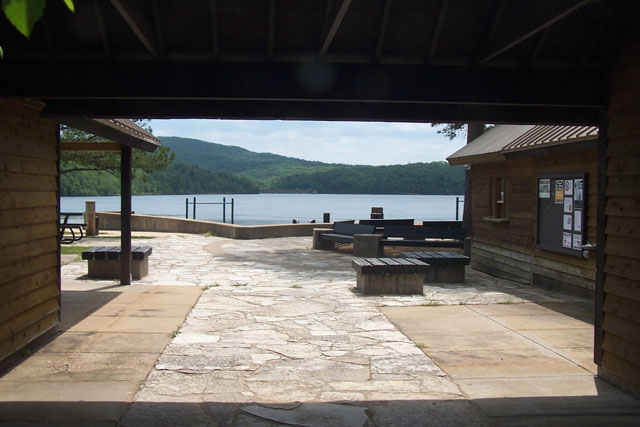
Recreation areas with activity Group Picnicking:Large Pavilion – This pavilion is down a paved road from the beach/grassy area. After you pass the concession stand you continue down the paved road and around the grassy area and will find this pavilion located on the bank of the lake, right next to the water. The pavilion has 8 tables and a group grill. It can accommodate a group of up to 74. There is an outdoor shower, water spigot, and restroom next to this pavilion.
Small Pavilion - This pavilion is down a paved road from the beach/grassy area. You can find it just as you enter the site, on the left. This site is in a wooded area above the paved road. This pavilion has 4 tables, a trashcan, and a group grill. It can accommodate a group of up to 25.
| No. of Sites | 2 pavilions |
Boating - Motorized
Recreation areas with activity Boating - Motorized:Boat Motors limited to 10 horsepower, or no wake.
Enough Boat Launch is a single-lane gravel launch. Over by the Enough boat launch there is an abundance of lily pads. Because this lake was built due to dam construction there are trees in the lake by this boat launch and around the perimeter of the lake. Once you are in the middle of the lake and by the beach there are few submerged trees from the flooding to create the lake.
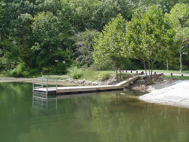
Wild Boar Hollow Boat Launch is a single-lane concrete launch with a boat dock. If you are using a motorized watercraft it may be preferable to launch from Wild Boar Hollow.
| Type of Craft | Jet skis are prohibited. |
| Size Restrictions | Recommended sizes is under 40 feet. |
| Motor Type | Electric or gas motors are allowed. |
| Water/Flow Level | 87 feet at maximum depth, 440-acres |
Boating - Non-Motorized
Recreation areas with activity Boating - Non-Motorized:Visitors frequently come to canoe, kayak or paddle board on Council Bluff Lake.
Enough Boat Launch is a single-lane gravel launch. Over by the Enough boat launch there is an abundance of lily pads. Because this lake was built due to dam construction there are trees in the lake by this boat launch and around the perimeter of the lake. Once you are in the middle of the lake and by the beach there are few submerged trees from the flooding to create the lake.
Wild Boar Hollow Boat Launch is a single-lane concrete launch with a boat dock. If you are using a motorized watercraft it may be preferable to launch from Wild Boar Hollow.
| Size Restrictions | Recommended sizes is under 40 feet. |
| Water/Flow Level | 87 feet at maximum depth, 440-acres |
| Status: | Open |
|---|
Swimming
Recreation areas with activity Swimming:There is a 1.25 acre sand beach in front of the concession stand, that can be busy on a hot weekend.
Kids can enjoy a small playground with a slide and climbing structures on the beach.
There is a paved sidewalk that winds around in front of the beach on a raised up embankment, and there are two sets of wide-stairs down to the beach area.
Amenities at the beach include a concession stand operated by the concessionaire, coin-operated private hot showers, flush toilets, water fountains and outdoor showers. There is one large and one small accessible picnic pavilions with tables and grills.
The area is not managed for swimming: there are no lifeguards, depth or hazard markers, and the water is not tested.
The swimming area is delineated by buoys and floating plastic pipe. Outside of this area you may encounter motorized boats.
| Status: | Closed |
|---|
Amenities
| Camping trailer: | Yes |
|---|---|
| Picnic tables: | Yes |
| Tent camping: | Yes |
| Parking: | Beach: 75 vehicles; Enough Boat Launch: 12 vehicles with trailers; Wild Boar Hollow Boat Launch: 25 vehicles with trailers |
| Toilets: | Yes |
| Fee charged for some activities: | Yes |
| Accessible: | Some features and amenities are acessible |
| Boat ramp: | Yes |
| Drinking water: | Yes |
Quick Links
Related Information
Highlights
Location


