
Official websites use .gov
A .gov
website belongs to an official government organization in the
United States.
Secure .gov websites use HTTPS
A lock
(
) or https:// means you've safely
connected to the .gov website. Share sensitive information only
on official, secure websites.


Olson Observation Tower
Originally built in 1922 by the state, Backbone Mountain was the site of the first fire tower in the State of WV. It was later transferred to the Monongahela National Forest and was used until 1963 when it was replaced and named Olson Tower.
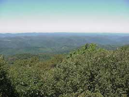
Olson Tower sits on the mountain top. Climb the 133 steps for breathtaking views. Although the cabin is closed to the public, you are welcome to climb to just below the cabin structure. Breathtaking views of the town of Parsons, Blackwater Canyon, Otter Creek Wilderness, Canaan Mountain, and the Cheat River watershed can all be seen from the tower heights.
Olson Tower is located on Backbone Mountain in Tucker County. The elevation is approximately 3736 feet above sea level. It is accessible most of the year by a dirt road. There are several trails in the area, including; Canyon Rim Trail # 117 Is 3 miles in length and begins 0.1 miles below the picnic area and Limerock Trail # 142 Is 4.1 miles in length and located along FR 18.
At a Glance
| Current Conditions: | Open when roads are snow-free. |
|---|---|
| Operational Hours: | Daylight hours, only during open season. |
| Open Season: | When roads are snow-free - December |
| Closest Towns: | Parsons, WV |
| Operated By: | Forest Service |
| Information Center: | Cheat Ranger District |
General Information
Directions:From Parsons travel approximately 7 miles north (east) on 219N. Turn right on Forest Road 18. Travel 0.4 miles and stay to the right at the Y intersection. This is FR 717. Continue on FR 717 1.6 miles to the parking lot below the tower.
Activities
Viewing Scenery
The fire tower sits on the mountain top. Climb the 133 steps for breathtaking views. Although the cabin is closed to the public, you are welcome to climb to just below the cabin structure. Breathtaking views of the town of Parsons, Blackwater Canyon, Otter Creek Wilderness, Canaan Mountain, and the Cheat River watershed can all be seen from the tower heights.