
Official websites use .gov
A .gov
website belongs to an official government organization in the
United States.
Secure .gov websites use HTTPS
A lock
(
) or https:// means you've safely
connected to the .gov website. Share sensitive information only
on official, secure websites.


Shockaloe Trail
The nationally recognized Shockaloe Trail is listed in the National Register of Trails. A trip along the trail allows the rider or hiker to view more than 60 years of forest management practices in the area. Some notable items of interest are sound timber and prescribed fire management practices, superior trees, flatland hardwoods, wildlife openings and watering holes and endangered species.
There are two base camps associated with Shockaloe Horse Trail: Base Camp I and Base Camp II. Each base camp has a pavilion and an open area for parking. Camping is only permitted at Base Camp I. Camping is not permitted at Base Camp II.
Have at least two adults in your party. Park trucks and trailers in spaces provided. Keep all facilities clean. Carry first aid supplies with each party. Be careful crossing roads. No public telephones are available. Wearing orange/bright colored clothing during deer hunting season is recommended.
In case of emergency, contact Scott County Sheriff's Office at 601-469-1511.
At a Glance
| Current Conditions: | Day use only. Self-contained RVs only. Restroom closed. |
|---|---|
| Area Amenities: | Drinking water, Parking |
| Fees: | Price per day: $7 camping (this includes use of the trail). Camping is only permitted at Base Camp I. Camping is not permitted at Base Camp II. |
| Open Season: | March 1-December 15 (Base Camp 1 and 2 only) |
| Restrictions: | No alcoholic beverages allowed. No all-terrain vehicles allowed on trail. Camping limit of 14 days. Camping is only permitted at Base Camp I. Camping is not permitted at Base Camp II. |
| Water: | Drinking |
General Information
Directions:The Shockaloe Trail is located on the Bienville National Forest between Forest, MS and Morton, MS, just north of U.S. Highway 80. Base Camp I is located .25 mile north of U.S. Hwy. 80 on Forest Service Road 513. Base Camp II is located approximately 5 miles further north on Forest Service Road 513.
Activities
Mountain Biking
Mountain bikes (non-motorized) are allowed.Campground Camping
Camping at Base Camp I only. No camping at Base Camp II.
| Fire Information | Cooking Grills |
Day Hiking
The trail consists of a winding 23 miles of travelway which takes the traveler through a variety of terrain and vegetation types found in the area, and allows the traveler to view first-hand multiple use management practices on the national forest. The trail crosses several local roads and allows the hiker the option of several routes of varying lengths from a mile and a half to the full 23 miles.
Horse Camping
Camping is permitted at Base Camp I. Camping is not permitted at Base Camp II.
General Info:
General NotesCooking grills available.
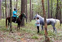
Horse Riding
The trail consists of a winding 23 miles of travelway which takes the visitor through a variety of terrain and vegetation types found in the area and allows the traveler to view first-hand multiple use management practices on the national forest. The trail crosses several local roads and allows the rider the option of several rides of varying lengths from a mile and a half to the full 23 miles.
The trail is marked throughout its length with signs and markers. The standard marker is a wooden sign with a horse and rider engraved on it. These markers are placed at intervals along the trail and are easily followed while using the trail.
| Water Availability | Wildlife Water Holes |
| Hitching Rails | Yes |
Picnicking
| Fire Information | cooking grills |