
Official websites use .gov
A .gov
website belongs to an official government organization in the
United States.
Secure .gov websites use HTTPS
A lock
(
) or https:// means you've safely
connected to the .gov website. Share sensitive information only
on official, secure websites.


Hazard County Trail
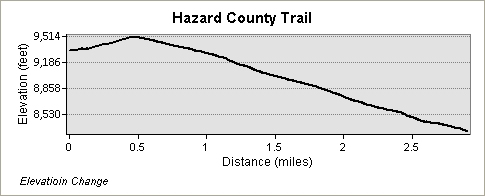
The Hazard County Trail #903 is 2.9 miles long. This trail travels between Forest Road #650 (Wilcox Flat) just off of Forest Road #063 (Warner Lake Road) and Forest Road #046 (La Sal Mountain Loop). This trail steadily descends from the Warner Campground area travelling through a mix of meadows, and aspen and Gambel oak forest before intersecting Forest Road #046 (La Sal Mountain Loop). This trail is a section of the Whole Enchilada Mountain Bike Trail. This section connects Forest Trail #033 (Warner Lake/Beaver Basin) and #315 (Burro Pass) the two highest elevation sections to the lower portions of the trail; Forest Road #634 (Kokopelli’s) and Forest Trail #973 (UPS). This popular trail sees use by multiple different types of users, primarily, hikers, mountain bikers and equestrian users. Please respect one another and observe standard trail etiquette: mountain bikers yield to both hikers and equestrian users and hikers yield to equestrian users.
Elevation Change:
South East End (Road #650): 9,340 feet
North West End (Road #046): 8,330 feet
At a Glance
| Current Conditions: | Closed due to snow |
|---|---|
| Usage: | Heavy |
| Restrictions: | Open to: Hiking, Mountain Biking and Horseback Riding. |
| Closest Towns: | Castle Valley and Moab, UT |
| Water: | Water is unavailable on this trail. Users should carry water. |
| Restroom: | Restrooms available at the trailhead and at Warner Campground. |
| Operated By: | Forest Service |
| Information Center: | Moab Ranger District (435) 259-7155 |
General Information
Directions:From Moab, head south on US-191/Main St and travel 7.8 miles. Turn left onto Co Rd #127/Old Airport Rd (brown sign indicating Ken’s Lake and La Sals is located at the turn on US-191) and travel 0.6 miles. Turn right onto Co Rd #127/Forest Road #046 (La Sal Mountain Loop) and travel 11.5 miles. Turn right onto Forest Road #063 (Warner Lake) and travel approximately 5.0 miles. A sign indicates Hazard County Trailhead, which is located on the left.
General Notes:
Latitude: 38 32' 32.8"N
Longitude: 109 18' 43.7"W
Datum: NAD83
Position Format: Degrees Minutes Seconds
Activities
Mountain Biking
Mountain Biking/non-motorizedDay Hiking
Hiking


Location