
Official websites use .gov
A .gov
website belongs to an official government organization in the
United States.
Secure .gov websites use HTTPS
A lock
(
) or https:// means you've safely
connected to the .gov website. Share sensitive information only
on official, secure websites.


Upper Wills Canyon Trail (T9278)
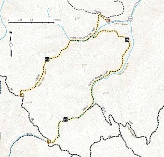
Trail map for the Willie White and Wills Canyon Area Trails on the Sacramento Ranger District.
Click on the map for a clearer and printable version of the map.
Trail #9278: The Upper Wills Canyon trail is 4.0 miles long. It begins at the end of County Road D18 (Wills Canyon Rd) and ends at the Hubbell Canyon trail (T9277). The trail is open for the following uses: Hiking, Horseback Riding, Mountain Biking, Motorcycle Trail Riding, Off Highway Vehicles (OHV) less than or equal to 50 inches wide.
At a Glance
| Usage: | Heavy |
|---|---|
| Restrictions: | No OHV's > 50" in width allowed |
| Closest Towns: | Cloudcroft |
| Operated By: | Forest Service |
General Information
General Notes:
 One of our many historic railroad grades now converted into a USFS trail. Either all or most of this trail follows the old steam engine route.
Activities
Mountain Biking
Day Hiking
Backpacking
Sacramento Ranger District trail.Horse Riding
Sacramento Ranger District trail.| Difficulty Level: | Moderate |
|---|
OHV Trail Riding
Sacramento Ranger district motorized trail. ATV's (<50" wide) and motorcycles allowed. Non-motorized use is also permitted.| Difficulty Level: | Moderate |
|---|
Location
