
Official websites use .gov
A .gov
website belongs to an official government organization in the
United States.
Secure .gov websites use HTTPS
A lock
(
) or https:// means you've safely
connected to the .gov website. Share sensitive information only
on official, secure websites.


Benson Canyon Spur Trail 2 (T5005B)
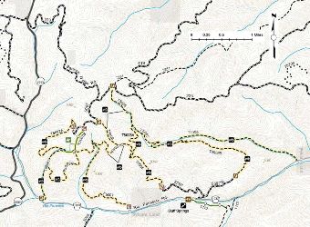
Trail map for the Benson Ridge area trails on the Sacramento Ranger District.
Click on the map for a clear and printable version.
Trail #5005B: The Benson Canyon Spur Trail 2 is 1.6 miles long. It begins at the Benson Canyon trail (T5005) and ends at Forest Road 5597B. The trail is open for the following uses: Hiking, Horseback Riding, Mountain Biking, Motorcycle Trail Riding, Off Highway Vehicles (OHV) less than or equal to 50 inches wide.
At a Glance
| Usage: | Heavy |
|---|---|
| Restrictions: | No OHV's > 50" in width allowed |
| Closest Towns: | Cloudcroft |
| Operated By: | Forest Service |
Activities
Mountain Biking
Day Hiking
Backpacking
Horse Riding
OHV Trail Riding
Off-Highway Vehicles (OHV's) <50" in width and motorcycles allowed.
Related Information
Location
