
Official websites use .gov
A .gov
website belongs to an official government organization in the
United States.
Secure .gov websites use HTTPS
A lock
(
) or https:// means you've safely
connected to the .gov website. Share sensitive information only
on official, secure websites.


North Fork Lone Pine Creek Trail
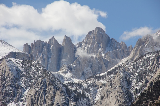
North Fork Lone Pine Creek trail includes the approach to the Mountaineers Route. This primitive trail is steep, rugged and difficult to follow as you climb up and scramble over the Ebersbacher Ledges to reach Boy Scout Lakes. Parts of the route cross granite slabs requiring route finding skills. The trail ends at Iceberg Lake at an elevation of about 12,600 feet.
There is not a hiking trail to the summit, routes above Iceberg Lake vary in technical climbing difficulty. Research recommended before attempting any climbing routes.
Common Destinations: Lower and Upper Boy Scout Lakes, Iceberg Lake. Aproach to climbing routes on Mt. Whitney include Mountaineers Route, East Face and East Buttress, as well as Fish Hook Arête and East Ridge to Mt Russell.
Download area map for trail names.
To purchase more detailed maps or guidebooks of the area, visit sierraforever.org
North Fork Lone Pine Creek Trail Recreation Guide (pdf)
List of Outfitter Guides permitted for the Mt Whitney area.
Safety Is Your Responsibility!
Wilderness travel involves an element of risk. Before visiting, develop a plan for dealing with emergencies. Travel with your group at all times. Report emergencies to Inyo County Sheriff at (760)878-0383. It may take up to several days for help to arrive.
Searches and Rescues are managed by Inyo County Sheriff and Inyo County SAR, a non-profit volunteer organization.
At a Glance
| Current Conditions: | 03/19/2024: Trail almost entirely snow covered. Whitney Portal Rd is closed near Hogback Rd, approximately 4 miles before reaching the trailhead. The road is blocked by snow 2 1/2 miles past the road closure sign. For Information about Whitney Portal Rd call Inyo County Road Department at 760-878-0212. |
|---|---|
| Reservations: |
|
| Permit Info: | Permit is required year round:
|
| Restrictions: |
|
| Closest Towns: | Lone Pine, CA (full service, hospital) |
| Information Center: |
|
General Information
General Notes:Dispose of waste properly.
The only acceptable way to dispose of human waste is to pack it out. Human waste pack-out kits are free with wilderness permits. Each year, Mt. Whitney visitors pack out almost 4 tons of human waste. More...
Store food and trash in bear-proof containers.
All food, food related trash and scented items must be stored in bear-proof containers, or counter balanced from a tree, at least 15 feet above the ground and 10 feet horizontally from the trunk. Counter balancing is difficult, and there are no suitable trees above Lower Boy Scout Lake. More...
Camp in established campsites.
Camp in established campsites or on durable surfaces, such as snow, granite or barren sand and gravel. Established campsites are are near Lower Boy Scout Lake, Upper Boy Scout Lake and Iceberg Lake.
Directions:
From Lone Pine, CA, travel 13 miles west on Whitney Portal Road. The Mt. Whitney trailhead is located on the north side of the road at Whitney Portal. From the trailhead, walk approximately 1 mile up the Mt. Whitney Trail, to North Fork of Lone Pine Creek. The North Fork trail begins at the creek crossing.
Parking is available at the trailhead. Please minimize the number of vehicles that your group uses.
There is a high level of bear activity at Whitney Portal trailhead. Plan ahead and clean out your vehicle before you arrive. The parking area has bear resistant trash cans and bear-proof lockers for storing food and scented items. Bear boxes are shaired with other visitors so organize your food in a bag or box and mark with your return date. Typical bear box size is 48" x 30" x 36".
Activities
Day Hiking
Backpacking


Related Links
Location
