
Official websites use .gov
A .gov
website belongs to an official government organization in the
United States.
Secure .gov websites use HTTPS
A lock
(
) or https:// means you've safely
connected to the .gov website. Share sensitive information only
on official, secure websites.


Oakwood Horse Trail
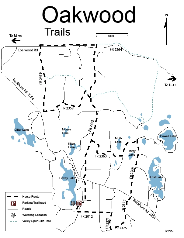
The Oakwood Trail system provides an 11-mile horseback riding route through a variety of forest types from oak to maple to pine. The terrain is mostly flat with occasional gentle hills. The route was signed and maintained by the North Coast Riding Club through cooperative arrangement. Trail markers are red, and locator maps were posted at trail intersections.
Most of the route is located on 2 – track roads open to motorized vehicles. Trail users should watch for approaching motorized vehicles. Link to Trail Map.
At a Glance
| Closest Towns: | Munising |
|---|
General Information
Directions:To reach the trailhead parking area, take the Buckhorn Road (FR 2254) to the Hovey Lake Road (FR 2473). Travel south on Hovey Lake Road for about a ½ mile. Turn right (west) on FR 2473 – C , and follow signs to the parking area. From there, trail users can access two loops, each approximately five miles long.
Activities
Horse Camping
Rustic Camping is allowed at the Trailhead. Existing facilities include:
• Vault Toilet
• Fire Ring
• Picnic Table
• High Line Posts (need to bring your own line)
Watering opportunities for horses occur at the south end of Hovey Lake .
Horse Riding
The Oakwood Trail system provides an 11-mile horseback riding route through a variety of forest types from oak to maple to pine. The terrain is mostly flat with occasional gentle hills. The route was signed and maintained by the North Coast Riding Club through cooperative arrangement. Trail markers are red, and locator maps were posted at trail intersections.
Related Information
Highlights
- Check out videos from around the Forest
- eBikes

Please note that our biking trails are designated "non-motorized." In keeping with agency direction, non-motorized trails are not open to eBikes. - How to Live with Black Bears

- Hiawatha Tour App
Use Hiawatha's OnCell app on your personal mobile device to take self-guided tours of natural and heritage sites. - Recreation, Heritage & Wilderness Management
National Forests are managed for multiple uses. Learn how these resources contribute!
Location


