
Official websites use .gov
A .gov
website belongs to an official government organization in the
United States.
Secure .gov websites use HTTPS
A lock
(
) or https:// means you've safely
connected to the .gov website. Share sensitive information only
on official, secure websites.


Trail #31 Lewis River, Curly Creek to Lower Falls
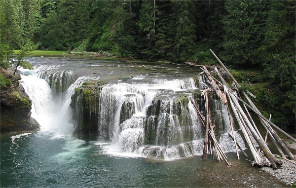
This 10.3 section of the Lewis River Trail #31 runs from Curly Creek Trailhead to Lower Falls.
Bolt Camp Shelter, 2.5 miles from the Curly Creek Trailhead, was constructed around 1921 by shake bolt cutters. It was restored by volunteers in 1991. Climbing above a basalt cliff gorge, the trail crosses Forest Road 90, 9.2 miles from the trailhead. Beyond the road crossing, the trail continues upriver 1.1 miles to Lower Lewis River Falls and Lower Falls Campground/Day Use Area. Here the Lewis River plunges over a 60-foot cliff creating a breathtaking panorama.
Special Conditions: Wet rocks and cliffs along the trail, and river may be slippery.
At a Glance
| Current Conditions: | 08/12/2023: This segment of the trail is logged out and open. Contact Mt. Adams Ranger District for current info. 509-395-3402. |
|---|---|
| Usage: | Medium |
| Restrictions: | Motorized vehicles prohibited |
| Closest Towns: | Cougar, WA |
| Water: | No |
| Restroom: | Vault Toilets at Lower Falls |
| Passes: | A valid Recreation Pass is required at Lower Falls Day Use area. |
| Operated By: | Forest Service |
| Information Center: | Mount Adams Ranger District |
General Information
Directions:Trail can be accessed from Curly Creek Trailhead (Forest Road 9039) or Lower Falls Recreation Area (Forest Road 90).