
Official websites use .gov
A .gov
website belongs to an official government organization in the
United States.
Secure .gov websites use HTTPS
A lock
(
) or https:// means you've safely
connected to the .gov website. Share sensitive information only
on official, secure websites.


Trail #71 Pine-Way
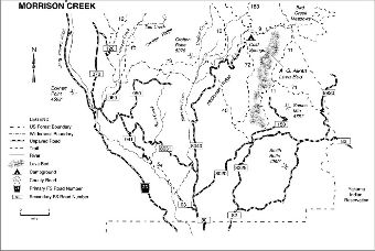
General trail guide for Morrison Creek area. Trails include: Snipes Mountain #11, Gotchen Creek #40, Buck Creek #54, Pine Way #71, Cold Springs #72, Crofton Butte #73, and Salt Creek #75.
This Trail Open to Hikers, Bikers and Equestrian Use.
Located in the eastern part of the Mt. Adams Ranger District, this trail is adjacent to the Yakama Indian Reservation. Cattle are ranged in the area and the first 0.5 mile of the trail is often used as a stock driveway. The second half of the trail, heading due west, is a cow trail through rocky terrain. It connects with Snipes Mountain Trail #11 near the A.G. Aiken lava flow. The entire length of the trail goes through the Cold Springs Fire of 2008.
At a Glance
| Current Conditions: | 11/06/2023: Trail received snow. For information contact the Mt. Adams Ranger Station 509-395-3402. |
|---|---|
| Fees: | No fee |
| Permit Info: | Wilderness Permit required if entering Mt. Adams Wilderness. Free self-issue Wilderness Permit available at trailhead. |
| Usage: | Light |
| Restrictions: |
|
| Closest Towns: | Trout Lake, WA |
| Operated By: | Forest Service |
| Information Center: | Mt. Adams Ranger District |
General Information
Directions:Pine-Way Trailhead via Forest Road 82 to Bureau of Indian Affairs Road 285