
Official websites use .gov
A .gov
website belongs to an official government organization in the
United States.
Secure .gov websites use HTTPS
A lock
(
) or https:// means you've safely
connected to the .gov website. Share sensitive information only
on official, secure websites.


Trail #39 Morrison Creek
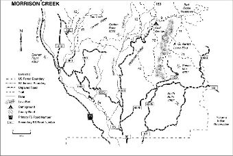
General trail guide for Morrison Creek area. Trails include: Snipes Mountain #11, Gotchen Creek #40, Buck Creek #54, Pine Way #71, Cold Springs #72, Crofton Butte #73, and Salt Creek #75.
This Trail Open to Hikers, Bikers and Equestrian Use.
This trail connects Crofton Butte Trail #73 to Gotchen Creek Trail #40 allowing for multiple loops when including Buck Creek Trail #54.
At a Glance
| Current Conditions: | 05/03/2024: Trail is accessible and logged out. Contact Mt. Adams Ranger District for further information 509-395-3402. |
|---|---|
| Usage: | Heavy |
| Restrictions: | Closed to All Motorized Use |
| Closest Towns: | Trout Lake, WA |
| Operated By: | Forest Service |
| Information Center: | Mt. Adams Ranger District |
General Information
Directions:Gotchen Creek Trailhead (Forest Road 8020)
Also accessed via Wicky Creek Trail # 38