
Official websites use .gov
A .gov
website belongs to an official government organization in the
United States.
Secure .gov websites use HTTPS
A lock
(
) or https:// means you've safely
connected to the .gov website. Share sensitive information only
on official, secure websites.


Campground: Adams Fork
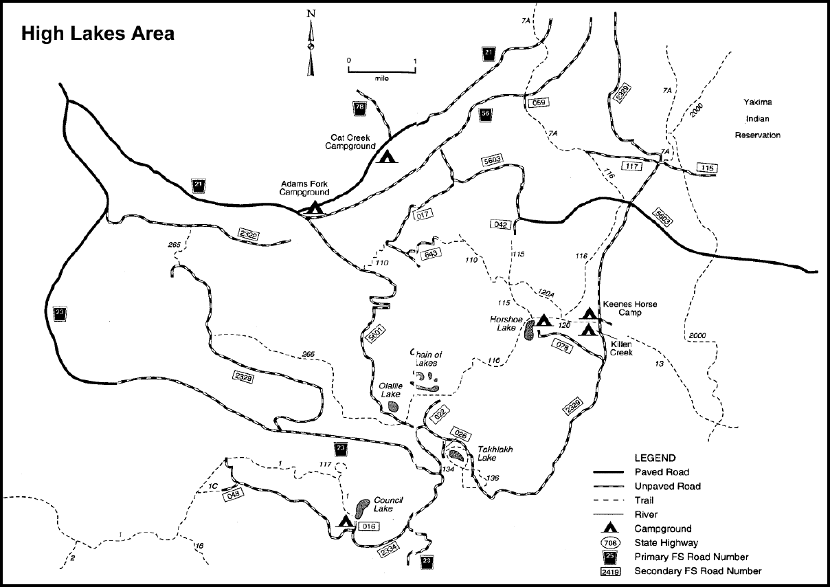
High Lakes area general map in the Cowlitz Valley Vicinity. Sites include: Adams Fork Campground, Boulder Trail #1C, Cat Creek Campground, Council Bluff Trail #117, Green Mountain Trail #110 , Hamilton Buttes Trail #118 , Hamilton Peak Trail #109, High Lakes Trail #116, Horseshoe Lake Campground, Keenes Horse Camp, Keenes Trail #120, Killen Creek Campground, Spring Creek Trail #115, East Canyon Trail #265, Takh Takh Meadow Trail #136.
This wooded area along the Adams Fork of the Cispus River makes a great campground location. The campground contains historic basket trees used by the Upper Cowlitz Tribe and has interpretive signage. The campground is located near the Off Highway Vehicle trails of Blue Lake Ridge and the Valley Trail and is frequented by motorized users.
There are 24 total campsites which includes 3 double sites.
View a Adams Fork Campground map (.pdf).
At a Glance
| Current Conditions: | 5/24/24: Campground maintained and operated by concessionaire ExplorUs. For reservations, please see the Reservations sections of this page. |
|---|---|
| Reservations: | Make reservations at Recreation.gov, or by calling 1-877-444-6777, up to 6 months in advance. *Some first come first serve sites are available. |
| Area Amenities: | Accessible, Tent camping, Camping trailer, Picnic tables, Toilets, Drinking water |
| Fees: |
|
| Open Season: | 05/17/2024 - 09/22/2024 |
| Usage: | Light-Medium |
| Restrictions: |
|
| Closest Towns: | Randle, WA; Packwood WA |
| Water: | Potable Water |
| Restroom: | Vault Toilet |
| Passes: | 50% discount for single site camping fee with any of these passes: Interagency Senior, Interagency Access, Golden Age, or Golden Access. |
| Operated By: | Concessionaire |
| Information Center: |
|
General Information
Directions:From Randle, Washington travel south on State Highway 131 (Forest Roads 23 and 25). Veer left in 1 mile at the Y of Forest Road 23 and Forest Road 25. Continue to follow Forest Service Road 23 for 18.5 miles then turn left onto Forest Road 21. Follow Forest Road 21 for 4.6 miles and turn right onto Forest Road 56. The campground is less than ¼ mile on the left.
Cowlitz Valley Ranger District
10024 US Hwy 12
PO Box 670
Randle, WA 98377
(360) 497-1100
TTY: (360) 497-1101
General Notes:
High Lakes area general map in the Cowlitz Valley Vicinity.
Activities
Campground Camping
Many of the sites are small. Close to ORV trails, the campground is popular with ORV riders. Campers should expect riders going out of campground. One multiple site is available.
| No. of Sites | 22 single site(s), 1 double site(s), 1 20-50 people group site(s) |
| No. of Accessible sites | None |
RV Camping
Situated in tall trees, many of the sites are small but still usable by RVs.
| No. of Sites | 21 |
| Reservation Info | This site can be reserved by calling Toll Free 1-877-444-6777 (International 518-885-3639 or TDD 877-833-6777) or on-line at www.recreation.gov. |
| Pavement Type for Parking | Asphalt |
| Hookup - Water | No |
| Size Restrictions | 22' |
| Hookup - Sewer | No |
| Dump Stations | No |
| Hookups - Electric | No |
| Corrals | 22' |
| Reservation info: | This site can be reserved by calling Toll Free 1-877-444-6777 (International 518-885-3639 or TDD 877-833-6777) or on-line at www.recreation.gov. |
|---|
Group Camping
| No. of Sites | 1 |
| Reservation Info | This site can be reserved by calling Toll Free 1-877-444-6777 (International 518-885-3639 or TDD 877-833-6777) or on-line at http://www.recreation.gov/campgroundDetails.do?contractCode=NRSO\&parkId=71642\&topTabIndex=CampingSpot |
River and Stream Fishing
See local fishing regulations.
| Fish Species | Brook trout |
OHV Camping
The Valley Trail network, popular with dirt bikes and ATVs, offers a 50 miles of multi-use trails close to this campground. No OHV riding within the campground.
| Size Restrictions | Maximum vehicle length 22' feet. |
| Corrals | Maximum vehicle length 22' feet. |
Picnicking
Picnicking in camp sites is available for a fee.
| No. of Sites | 21 |
Amenities
| Camping trailer: | length 18-40 feet |
|---|