
Official websites use .gov
A .gov
website belongs to an official government organization in the
United States.
Secure .gov websites use HTTPS
A lock
(
) or https:// means you've safely
connected to the .gov website. Share sensitive information only
on official, secure websites.


Trail #256 Burley Mountain
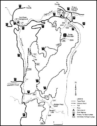
Burley Area General Map in the Cowlitz Valley Vicinity. Sites include:
Angel Falls Loop Trail #228B
Badger Ridge Trail #257
Boundary Trail #1
Burley Mountain Lookout
Burley Mountain Trail #256
Covel Creek Falls Trail #228A
Covel Creek Trail #228
French Butte Trail #254
Iron Creek Campground
Iron Creek Falls Trail #91
Iron Creek Old Growth Trail #83
Iron Creek Campground Loop Trail #187 Mosquito Meadows Trail #292
This trail is open to hiker use only.
There are a number of loop opportunities at the base of the Burley Mountain Trail that allow for hikes of differing lengths.
Start at the Cispus Learning Center, take the Covel Creek Trail #228, to the Covel Creek Falls Trail #228A, which ties in with the Angel Falls Loop Trail #228B. From here, the Burley Mountain Trail climbs steadily through an even-aged forest the result of massive forest fires in the Cispus Valley in the early 1900s. Look for the remnants of the old forest: huge, black stumps. The trail ends on Forest Road 7605, 3 miles shy of the summit of Burley Mountain. There is a fire lookout on the summit that is still being used for fire detection. The Burley Mountain Lookout Trail #256A takes hikers from the parking area in the saddle below the summit, climbs through huckleberries and wildflowers for half a mile to the fire lookout. Burley Mountain Lookout was built in 1934. It is one of three lookouts remaining on the Gifford Pinchot.
The portion of this trail that ties into Covel Creek trail #228, Covel Creek Falls trail #228A, and Angel Falls Loop trail #228B is regularly maintained while the remaining portion receives little maintenance.
At a Glance
| Current Conditions: | 6/1/23: Multiple access points possible to begin trail. Trail system should be free of snow expect some down trees or limbs as trail system has not recently been maintained. Burley Mountain Trail: 41 Reviews, Map - Washington | AllTrails |
|---|---|
| Usage: | Light |
| Restrictions: | This trail is open to hikers only and is closed to all other uses. |
| Closest Towns: | Randle, WA; Packwood, WA |
| Water: | No |
| Restroom: | No |
| Operated By: | Forest Service |
| Information Center: | Cowlitz Valley Ranger District |
General Information
Directions:Trail can be accessed from the Cispus Learning Center 2142 Cispus Road, Randle, WA 98377. (No day use fee)
From Randle, Washington travel south on State Highway 131 (Forest Roads 23 and 25). Veer left in 1 mile at the Y of Forest Road 23 and Forest Road 25. Continue to follow Forest Service Road 23 for 8.1 miles to the junction of Forest Road 28. Follow Forest Road 28 for 1.4 miles and turn right on Forest Road 76 . Follow Forest Road 76 for .7 miles. The trailhead for Covel Creek #228 is across from the entrance to the Cispus Center
Burley Mountain Trail can also be accessed from Forest Road 28: From Randle, Washington travel south on State Highway 131 (Forest Roads 23 and 25). Veer left in 1 mile at the Y of Forest Road 23 and Forest Road 25. Continue to follow Forest Service Road 23 for 8.1 miles to the junction of Forest Road 28. Follow Forest Road 28 for approximately 2.3 miles and arrive at the Burley Mountain Trail on your right. There is a small parking area on the left.