
Official websites use .gov
A .gov
website belongs to an official government organization in the
United States.
Secure .gov websites use HTTPS
A lock
(
) or https:// means you've safely
connected to the .gov website. Share sensitive information only
on official, secure websites.


Mt. Washington Wilderness: Deschutes
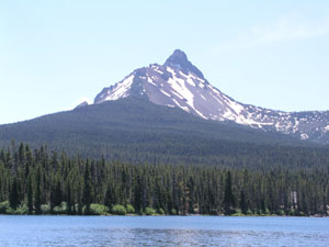
Mt. Washington rises above 75 square miles of lava-strewn plains which includes Belknap Crater, a 6,873-foot cinder and ash volcanic cone. This 54,278-acre Wilderness is a rugged retreat, primarily used by hunters, hikers, and mountain climbers. There are 28 lakes in the Wilderness.
The Pacific Crest National Scenic Trail extends for 16.6 miles through the Mount Washington Wilderness. It is the primary trail and extends from the north boundary near Big Lake to where it leaves the Wilderness at its southern boundary near the Dee Wright Observatory. Vegetation consists of lodgepole pine and associated species as well as mountain hemlock.
- Key access points: Trail and trailhead access information
-
Mt. Washington Wilderness Georeferenced Permit Map

This map highlights which trailheads require a Central Cascades Wilderness Permit for day use and those trailheads with day use opportunities requiring a free, self-issue permit at the trailhead.
At a Glance
| Current Conditions: | ALERT - Dry Creek Trail has not been maintained for years and has heavy "blow down" of trees killed by wildfire throughout the forest. The Shadow Lake fire of 2011 damaged the Dry Creek trail beyond repair. The trail is impossible to find in most places and filled with heavy blowdown. The East side of the Mt. Washington Wilderness provides a true Wilderness experience as there are no longer any maintained trails on that side of the crest.
|
|---|---|
| Fees: | Trails in the Mt. Washington Wilderness area require a Central Cascades Wilderness Permit for ALL overnight use and SOME require one for day-use.
|
| Permit Info: | There are two types of entry permits required between June 15 and October 15 for entering all designated wilderness areas.
|
| Usage: | Light |
| Restrictions: |
|
| Closest Towns: | Sisters, Oregon |
| Water: | Always carry water or a way to purify water |
| Passes: | Some trailheads require a recreation pass. Check our Recreation Passes & Permits page for details. |
| Information Center: |
|
General Information
Directions:Access to Mount Washington Wilderness
- Dry Creek Access Point
- Pacific Crest Trail - Section between Highway 242 at McKenzie Pass, and Highway 20 at Santiam Pass.
See also: Willamette National Forest information about Mount Washington Wilderness.
Topo Maps
Clear Lake, Linnton Lake, Mount Washington, North Sister. Download free U.S. Forest Service Topo maps.
Buy maps online
Go to the U.S. Geological Survey (USGS) map store: https://store.usgs.gov/maps
Wilderness.net
Go to Wilderness.net for online maps and other important Wilderness information.
General Notes:
Know Before You Go
- All overnight and some day use visitors to the Mt. Washington Wilderness must carry a Central Cascades Wilderness Permit if visiting between June 15 and October 15.
- Learn about Wilderness Regulations, including special area regulations in the Mt. Washington Wilderness.
- ''Leave No Trace'' techniques are encouraged in Wilderness areas, including properly disposing of human and pet waste and carrying out all trash.
- There are no facilities within the Mt. Washington Wilderness.
- Find out about the Weed Free Feed Requirement and other good Know Before You Go tips.

