
Official websites use .gov
A .gov
website belongs to an official government organization in the
United States.
Secure .gov websites use HTTPS
A lock
(
) or https:// means you've safely
connected to the .gov website. Share sensitive information only
on official, secure websites.


Angel Windows Trail #218
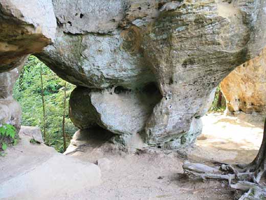 Angel Windows Trail begins at the Parched Corn Overlook off KY 715. The trail extends along a wooded ridge that leads under a high cliff to Angel Windows - two small arches clustered together at the end of the cliff. You will pass a number of overhangs and continue along the ledge. The official trail ends here, where there are some lovely views of the cliffs. Just beware of the drop-off to the right as you go past Angel Windows and use caution when exploring the area. Angel Windows Trail is located in the Red River Gorge on Cumberland District of the Daniel Boone National Forest.
The Red River Gorge Geological Area has more than 100 natural arches, the greatest concentration of arches east of the Rocky Mountains.
Use caution when hiking near cliffs. The clifflines in the Red River Gorge are beautiful, but they are also dangerous. A fall from a cliff can be dangerous or cause serious injury.
Angel Windows Trail Guide and Map (pdf)
Trailhead: Angel Windows Trailhead
Avenza Digital Maps
A Red River Gorge digital map is available from the Avenza Maps online map store. For the best user experience, use our maps within a GPS-enabled mobile app such as Avenza Maps.
At a Glance
| Passes: | No fee for trail use. All vehicles on KY 15 or in the Red River Gorge and Indian Creek area north of KY 15 must display a recreation permit for backcountry camping between the hours of 10 p.m. and 6 a.m. $5/day; $7/3 days; $50/annual pass. Recreation Passes and Permits |
|---|---|
| Information Center: | Gladie Office Contact Information |
General Information
Directions:
Traveling east on the Mountain Parkway, take exit 33 at Slade. Turn left toward KY 15. Turn right on 15 and travel east 7 miles to the junction with KY 715. Turn left on 715 and continue 3.8 miles to the Angel Windows parking area on the left.
From exit 40 off the Mountain Parkway, head west on KY 15 to the junction with KY 715. Turn right on 715 and continue 3.8 miles to the Angel Windows parking area on the left.
Parking:
Parking is available at the Angel Windows trailhead.
Activities
Day Hiking
Quick Links

Related Information
Featured Events
- The Boone Forest Rally
Date(s): Jul 26, 2024 - Jul 27, 2024
Location