
Official websites use .gov
A .gov
website belongs to an official government organization in the
United States.
Secure .gov websites use HTTPS
A lock
(
) or https:// means you've safely
connected to the .gov website. Share sensitive information only
on official, secure websites.


Multnomah Falls
The Multnomah Falls Lodge Visitor Center, restaurant, gift shop, snack bar and restrooms are open to the public.
Multnomah Falls is the most visited natural recreation site in the Pacific Northwest with more than 2 million visitors stopping by each year to take in the views. Fed by underground springs from Larch Mountain, the flow over the falls varies, but is usually highest during the winter and spring seasons. This is also one of the best places in the Columbia River Gorge National Scenic Area to study geology exposed by floods.
The Multnomah Falls Lodge, which is run by a concessionaire, is well maintained with restrooms, a Visitor Center, a snack bar, a gift shop and a restaurant that is fully ADA accessible. The visitor information area within the lodge is jointly staffed by Friends of Multnomah Falls volunteers and the U.S. Forest Service. Offerings include a simple trail map and brochures about Multnomah Falls in multiple languages. Books, detailed maps of the Columbia River Gorge & Pacific Northwest, and Northwest Forest Passes are also available for purchase.
On the lower level of Multnomah Falls Lodge is a U.S. Forest Service Visitor Center, snack bar, gift shop and restrooms. The restaurant is located on the upper level and can be accessed by stairs or elevator.


At a Glance
| Operational Hours: | Day-Use Only |
|---|---|
| Reservations: | A Timed Use Permit will be required daily from 9 a.m. until 6 p.m from May 24, 2024 through Sept. 2, 2024. Permits will be available online at www.recreation.gov for a $2 transaction fee starting May 10, 2024. |
| Open Season: | Year-round |
| Usage: | Heavy |
| Restrictions: |
|
| Closest Towns: | Troutdale, OR |
| Water: | Yes |
| Restroom: | Flush toilets |
| Operated By: | Forest Service manages recreation area and visitor center. Concessionaire operates the Lodge. |
| Information Center: |
|
General Information
Directions:From Portland, OR travel east on I-84 to Exit 31 (off ramp is on the left). Park and walk south, underneath eastbound I-84 and the railroad tracks and carefully cross the Historic Columbia River Highway to get to the Historic Lodge and Visitor Center.
From Cascade Locks, travel west on I-84 to Exit 31 (off ramp is on the left).
Timed Use Permits are required daily from 9 a.m. until 6 p.m from May 24, 2024 - Sept. 2, 2024 for anyone utilizing the I-4 parking lot.
Car Free options: The Columbia Gorge Express offers daily bus service between the Gateway Transit Center in Portland, Troutdale, Multnomah Falls, Cascade Locks and Hood River, Oregon. Summer options include the Waterfall Trolley based in Corbett, Oregon. There are other commercial shuttle and ebike options that can be found with a quick search on the Internet.
Accessibility: There is accessible parking available. A path leading to the Visitor Center from the parking lot is paved. There are some slight inclines along the path from the parking lot to the visitor center and around the falls viewing area.
Limited accessible parking is also available in front of the lodge along the Historic Columbia River Highway.
General Notes:
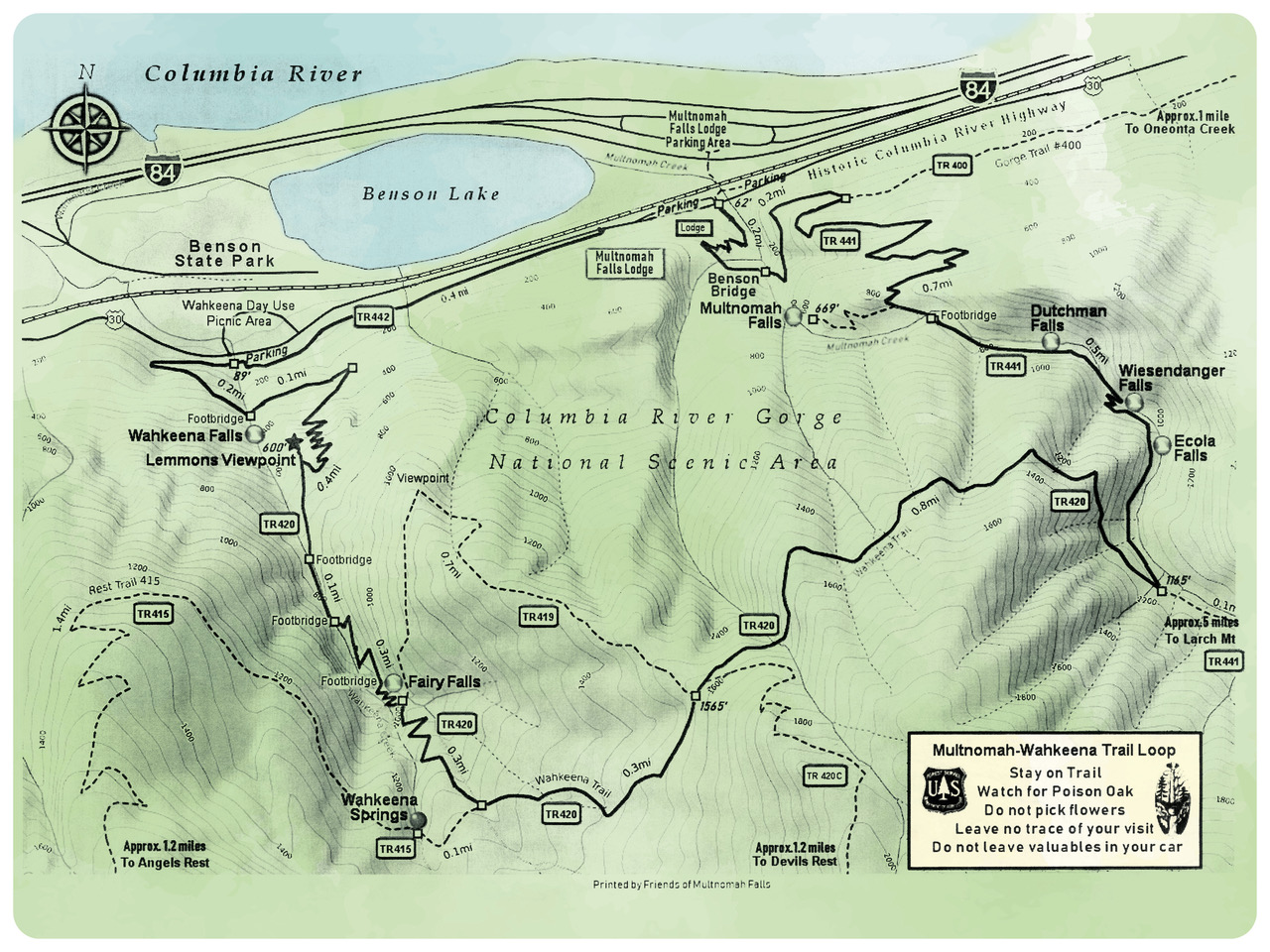
Download or Print a Multnomah-Wahkeena Loop Trail Vicinity Map:
Multnomah Falls area photos:


Accessibility:
Watch the video below to gain a sense of what the experience of visiting Multnomah Falls Lodge and Recreation Area is like (View on Youtube):
Activities
Day Hiking
One of the most popular hikes in the Columbia River Gorge. From the Multnomah Falls visitor center, a steep trail climbs to cross the historic Benson Bridge. Beyond the bridge those seeking a more rigorous experience can continue to the top of the cliff and take a short spur trail to a small viewing area at the very top of the falls. The total distance to the top of the falls and back is 2.4 miles, making this a great day hike. Hikers up for a longer climb can continue on Larch Mountain Trail for six miles to the top of Larch Mountain. Please consider whether you have the proper footwear and the 10 hiking essentials before continuing onwards after the bridge.
Backpacking
The trail that starts at the base of Multnomah Falls is actually Larch Mountain Trail, which continues to the top of Larch Mountain, creating the potentially for a backpacking trip. Please consider whether you have the proper footwear and the 10 hiking essentials before continuing onwards after the bridge.
Viewing Scenery
At 620 feet Multnomah Falls is the highest water fall in the Columbia River Gorge. This trail provides great views of the falls and the Columbia River Gorge.
Picnicking
5 accessible tables on site
| No. of Sites | 5 |
| Reservation Info | None |
Areas for Picnicking at Multnomah Falls


Related Information

Highlights
Location