
Official websites use .gov
A .gov
website belongs to an official government organization in the
United States.
Secure .gov websites use HTTPS
A lock
(
) or https:// means you've safely
connected to the .gov website. Share sensitive information only
on official, secure websites.


Salmo-Priest Wilderness
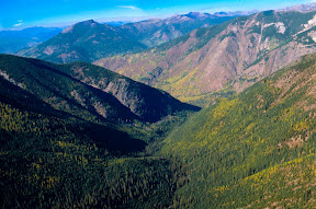
Tucked among the Selkirk Mountains in the extreme northeastern corner of Washington, the U-shaped 43,348 acre Salmo-Priest Wilderness extends its borders along those of Idaho and British Columbia. Its most prominent features are two very long ridges, generally running southwest to northeast, connected near their northern ends by a ridge crowned by 6,828-foot Salmo Mountain. The eastern ridge stands lower, more wooded, more rounded off and more accessible than the steep-sided, rocky-crested western ridge. Streams have cut deep drainages into both ridges. Water from the eastern side of the eastern ridge ends up in Idaho's Priest River. The remaining wilderness drains generally westerly via Sullivan Creek and the Salmo River into the Pend Oreille River.
Below the ridge tops of this well-watered Wilderness (at 50+ inches of precipitation annually) you'll find the largest growth of virgin forest left in eastern Washington: western red cedar, western hemlock, Douglas fir, grand fir, larch. The forest houses mule deer and white-tailed deer, elk, black bears, cougars, bobcats, badgers, pine martens, lynx, bighorn sheep, and moose. Though rarely sighted, threatened and endangered species including woodland caribou, grizzly bears and gray wolves also roam through this region. Winter snows may blanket the ground until early July at higher elevations.
The Shedroof Divide Trail, the longest path in the area at 21.8 miles, follows the extent of the eastern ridge through open timber and subalpine meadows. It traverses several miles of non-wilderness ridgeline into Idaho, where another 17,585 acres of roadless terrain has been proposed for addition to the Salmo-Priest. The 7.8-mile Crowell Ridge Trail traces the narrower western ridge, offering splendid overviews of trailless backcountry to the north. Several other feeder trails ascend drainages to interconnect the two primary ridge trails.
At a Glance
| Restrictions: | Motorized equipment and equipment used for mechanical transport is generally prohibited on all federal lands designated as wilderness. This includes the use of motor vehicles, motorboats, motorized equipment, bicycles, hang gliders, wagons, carts, portage wheels, and the landing of aircraft including helicopters, unless provided for in specific legislation. |
|---|---|
| Closest Towns: | Metaline Falls, WA |
| Information Center: | Trails are usually snowed in until June. Sullivan Lake Ranger District |
General Information
Directions:- Elevation Range: 2000' to 6828'
-
Key Access Points:
- Forest Servie Roads: #2200000, #2220000, #2212200, #2212245, 3155000
- Salmo Basin Trail #506, Salmo Divide #535, Shedroof Cutoff Trail #511, Shedroof Divide Trail #512, Red Bluff Trail #553,
Topo maps
Download free U.S. Forest Service Topo maps.
Buy maps online
Go to the National Forest Store.
Wilderness.net
Go to Wilderness.net for online maps and other important Wilderness information.
Activities
Day Hiking
Backpacking
Horse Camping
Horse Riding
Viewing Wildlife
Viewing Plants
Viewing Scenery


Location
