
Official websites use .gov
A .gov
website belongs to an official government organization in the
United States.
Secure .gov websites use HTTPS
A lock
(
) or https:// means you've safely
connected to the .gov website. Share sensitive information only
on official, secure websites.


Palatki Heritage Site
This site closes when the temperature is over 100 degrees Fahrenheit or when the roads are impassable.

Ancient Cliff Dwelling and Pictographs Sheltered by Colorful Cliffs of Red Canyon
Reservations are required! Visit Recreation.gov.
 The Palatki Heritage Site and its sister site, Honanki, were the largest cliff dwellings of the Red Rock Country between AD 1150 - 1350. They were first described by Dr. Jesse Walter Fewkes, famous turn-of-the century archaeologist from the Smithsonian Institution, who gave them the Hopi names of Honanki (Badger House) and Palatki (Red House). The Hopi, however, have no specific names for these sites.
The Palatki Heritage Site cliff dwelling and rock art site is located near the town of Sedona in north-central Arizona. Currently managed by the U.S. Forest Service under the Red Rock Pass Program, the site is open to the general public for visits seven days a week (closed Thanksgiving and Christmas). A small visitor center and bookstore, run by the Arizona Natural History Association, is located a short distance from the parking lot.
There are three trails at Palatki Heritage Site: One trail that takes you up to the Sinagua cliff dwellings (this trail includes 60 uneven fairly strenuous steps, please be aware of personal limitations), One that takes you to a view of the dwellings which is wheelchair accessible and a third that goes to the alcoves that shelter the painted symbols, or pictographs from every native culture to ever occupy the Verde Valley. These trails, each ¼ mile one way, making the round-trip distance 1 ½ mile.
Due to the limited amount of space on site, the tours are limited to 12 visitors at a time. Dwelling and Grotto tours are offered every half-hour and last about 1½ hours. Reservations are required. Read our Archaeological Site Etiquette Guide.
Pets are not allowed beyond the parking area at this heritage site.
Take a virtual tour of the Palatki and other heritage sites.
At a Glance
| Current Conditions: | This site closes when the temperature is over 100 degrees Fahrenheit. |
|---|---|
| Operational Hours: | Please visit Recreation.gov to see operation and tour times.
|
| Reservations: | Reservations are required. Visit Recreation.gov to make your reservation. |
| Fees: | To enjoy the Palatki facilities, please be sure to have: |
| Usage: | Heavy |
| Closest Towns: | Sedona, AZ |
| Water: | Drinking Water |
| Restroom: | Vault Toilets |
| Operated By: | US Forest Service |
General Information
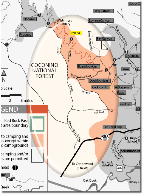
Directions:Location: 13 miles northwest of Sedona, Arizona.
GPS (Map): 34°54'53.6"N 111°54'08.4"W
Access:
- From Sedona, via SR 89A: Take SR 89A through West Sedona and continue past the last traffic light for five miles. Just past mile marker 365, turn right onto Forest Road 525. Go north for 5 miles and when FR 525 bears left, continue straight ahead onto Forest Road 795 for two miles. This road will lead directly into the Palatki parking lot.
- From Sedona, via Boynton Pass Road: An alternative way to access Palatki it to travel through west Sedona on SR 89A, turn right onto Dry Creek Rd. There are signs at every intersection that will direct you towards Palatki. At the end of Dry Creek Road, turn left onto Boynton Pass Road (FR 152C). At the next stop sign, turn left again. In a couple of miles, the pavement will end and you should continue on the rough gravel road for three miles until you reach another T intersection where you should turn right. It is 2 miles to Palatki from this intersection. These roads are generally passable to passenger cars when dry, but it is not regularly maintained by the County and has some rough and rocky stretches.
- From Cottonwood: Take 89A north from Cottonwood. About 1/2 mile north of mile marker 364, turn left onto a dirt road (FR 525 to FR 795; passable for passenger cars when dry), and drive 7 miles to Palatki Heritage Site and the parking lot.
Note: The roads to Palatki are rough gravel roads. Passenger cars can get to Palatki but drivers need to go slowly and carefully. Plan on taking at least 30 minutes from the time you leave Sedona to get to Palatki. After substantial rain and snow, Palatki Heritage Site may be closed; signs indicating the closed status will normally be posted at key access points.
General Notes:
Click map thumbnail for larger view.
Activities
Interpretive Areas

Related Information
Location

