
Official websites use .gov
A .gov
website belongs to an official government organization in the
United States.
Secure .gov websites use HTTPS
A lock
(
) or https:// means you've safely
connected to the .gov website. Share sensitive information only
on official, secure websites.


Humphreys Trail No. 151
Humphreys Trail is part of the Kachina Trail System.
This steep mountain trail leads to the highest point in Arizona. If you consider it merely as a means to that end, however, you'll miss much of the reason to come here. The trails runs approximately 5 to 5.5 miles in length one way, so make sure you start early in the day if you are planning a roundtrip day hike. Along its course, a thriving alpine forest streaked with huge rock slides and avalanche tracks hugs the mountain's slopes. Scenic Hart Prairie stretches out the base of the incline and the Grand Canyon is easily visible on the horizon.
As the elevation increases, trailside vegetation shows more evidence of the extreme harshness of this environment. Near tree line what's left of the forest consists entirely of bristlecone pines bent and twisted by wind and frost. This hardy tree manages to live one of the longest lives on earth in one of the planet's most inhospitable environments. Above tree line the only plants that can survive are small tundra shrubs and wildflowers that huddle for shelter among the rocks. Some are found nowhere else in the world. Overhead, above Arizona's highest ridge, white-throated swifts dive and flash like miniature fighter planes as they feed on nearly invisible insects borne on the wind.
Humphreys Trail is steep and long and extremely rocky in its higher reaches. Above treeline it exposes you completely to the whims of nature. Here it may snow during any month of the year. In late summer monsoon storms can set the high country snapping with lightning. Be prepared to turn around and head for lower ground if a thunderstorm is brewing!
From the Top
Once you do reach the summit ridge you'll feel like you're standing on top of the world. Off in the distance, the Grand Canyon, the Painted Desert, the mesas that are home to the Hopi Indians the Verde Valley and Oak Creek Canyon form a 360 degree panorama. And after you've seen it you'll be able to say you've been as high as you can get in Arizona.
- Slide Show "Hiking the Kachina Peaks Wilderness Trails"
Humphreys Trail Statistics:
- Difficulty: Strenuous
- Length: 4.8 miles
- Trailhead Elevation: 9340 feet
- Elevation Gain/Loss: 3420 feet
- Use: Hiking
At a Glance
| Current Conditions: | For current weather, visit National Weather Service. When there is snow on the San Francisco Peaks check the Kachina Peaks Avalanche Center Snowpack Summary for avalanche danger information. |
|---|---|
| Usage: | Medium-Heavy |
| Best Season: | Late Spring thru Fall |
| Closest Towns: | Flagstaff, AZ |
| Operated By: | Flagstaff Ranger District - 928-526-0866 |
| Information Center: | Please be aware: - No mechanized or motorized vehicles, including bicycles, in Wilderness Areas. - There is no hiking off-trail or camping above the treeline (11,400'). - You may camp below the treeline, maintaining a reasonable distance from the trail--but you cannot camp within Snowbowl boundaries. |
General Information
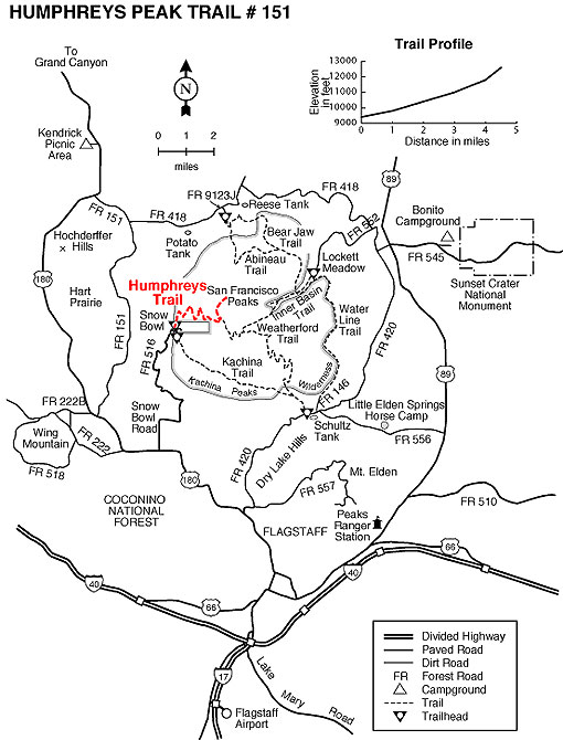
Directions:Location: 14.5 miles northwest of Flagstaff on paved roads.
GPS (Map): 35°19'52.4"N 111°42'42.2"W
USGS Map: Humphreys Peak Quad
Access: From Flagstaff drive north on US 180 for 7 miles to FR 516, the Snowbowl Road. Drive 7.4 miles on this paved road to the lower parking lot of the Snowbowl facility. The trailhead is located at the north end of the parking lot (see photo).
Select the map thumbnail for larger view.
General Notes:
Hiking Time: Approximately 3 to 4 hours (one way)
Notes: The trail begins at approximately 9,200 ft in elevation, so the air is much thinner than most are used to. As you ascend, breathing can be more challenging and you may need to stop more frequently to catch your breath. This hike is strenuous and hiking poles are very useful. Also keep in mind that even though the temperature at the trailhead is pleasant, it can be much colder above the treeline and much more windy.
Activities
Day Hiking
General Info:
General NotesParking
XC Skiing/Snowshoeing
Humphreys Trail would NOT be good for Cross Country Skiing, but if you hike this trail in the winter, snowshoes might be helpful.